
|
|---|
|
|
|---|
|
|---|
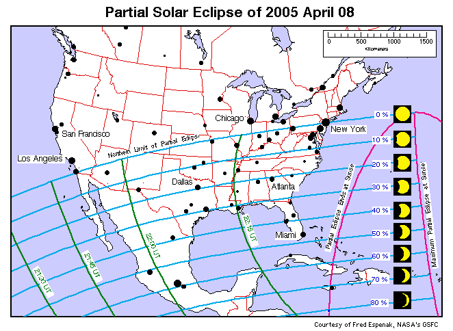
This map shows the regions of visibility of the solar eclipse of April 8, 2005 in the USA. The eclipse will be visible south of a line extending across the nation from southernmost California to central New Jersey. The eclipse magnitude (fraction of the Sun's diameter covered by the Moon) varies from 0% along the northern limit to nearly 50% in southern Florida. Eclipse magnitude curves labeled 10% through 80% can be used to estimate the degree of the eclipse from any part of the USA and Mexico. This map is also available in a High Resolution version.
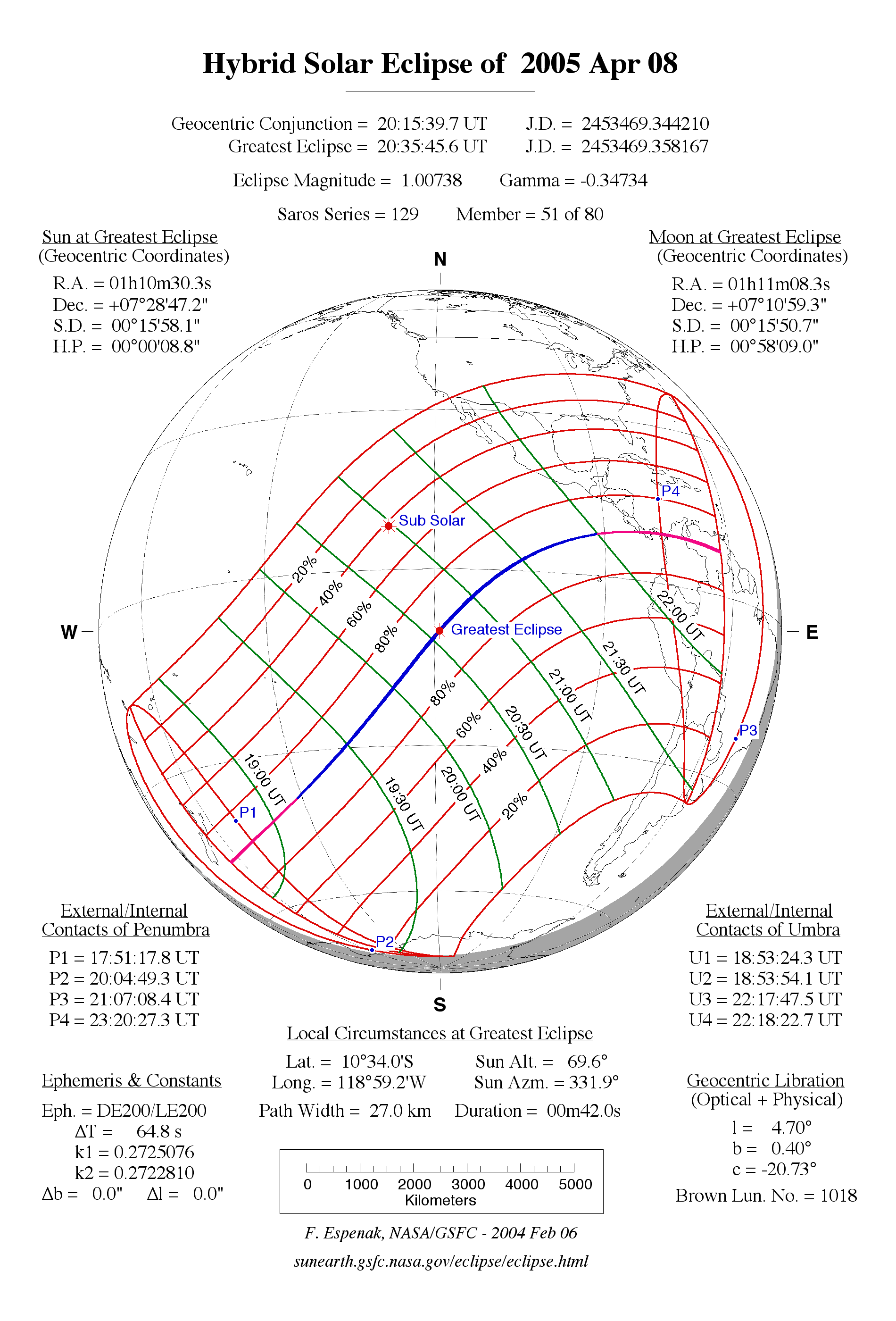
An unusual hybrid eclipse of the Sun occurs on April 8, 2005. The central path of the eclipse runs across the South Pacific where it changes from an annular eclipse to a total eclipse and then back to an annular eclipse again before reaching Central America. For more information on this rare event, see: Hybrid Solar Eclipse of 2005.
This eclipse will be seen as a partial eclipse from the southern half of the United States. More specifically, the eclipse will be visible from the USA south of a line extending across the nation from southernmost California to central New Jersey. No eclipse will be seen north of this line which is called the northern eclipse limit.
The size or magnitude of the eclipse increases as one travels to the southeast of the northern eclipse limit. For instance, the eclipse magnitude is about 5% in northern Texas but increases to 40% in the southernmost corner of the state. The maximum eclipse visible from the continental U.S. will take place in southern Florida where nearly 50% of the Sun's diameter will be covered by the Moon. The approximate time of maximum eclipse for each time zone throughout the USA is as follows:
     Pacific Daylight Time -  14:55 PDT (= 2:55 pm)
     Mountain Daylight Time - 16:05 MDT (= 4:05 pm)
     Central Daylight Time -  17:05 CDT to 17:17 CDT (= 5:05 pm to 5:17 pm)
     Eastern Daylight Time -  18:15 EDT to 18:20 EDT (= 6:15 pm to 6:20 pm)
This will be the last partial eclipse of the Sun visible from the continental U.S. until May 20, 2012.
The Eclipse magnitude is simply the percent of the Sun's diameter covered by the Moon. A detailed map at the top of this page shows the region of eclipse visibility in the USA. The map includes eclipse magnitude curves for different geographic locations. Eclipse magnitude is simply the percent of the Sun's diameter covered by the Moon at Maximum Eclipse. Times of Maximum Eclipse are plotted as green curves on the map are in Universal Time (UT) which is equal to Greenwich Mean Time. A unique eclipse animation shows the motion of the Moon's shadow across Earth's surface during the eclipse (courtesy of Dr. Andrew Sinclair).
|
|---|
What will the eclipse look like and when does it begin and end? That all depends on the geographic location of your city. You can see a graphic preview for over a hundred cities across the southern USA by visiting the following web page which features graphics prepared for the 2005 solar eclipse. Just got to the table for your country of geographic area, find your city in the table and click on it to see an eclipse diagram:
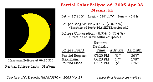
The above link takes you to a table of US cities listed in alphabetical order (by state). The table gives a brief summary of the eclipse circumstances as seen at each city and includes the times of start, maximum and end of the eclipse, the magnitude, the altitude of the Sun and the duration of the eclipse. As you click on the name of each city, you will see a figure illustrating the eclipse's appearance at maximum eclipse. A brief table lists the eclipse times as well as other details about the eclipse.
The eclipse is also visible from Central America as well as much of South America. Local circumstances for a number of cities are given in Table 2A-2D. Sun's altitude and azimuth, the eclipse magnitude3 and obscuration4 are all listed for the instant of maximum eclipse. A global map showing the world-wide visibility of the eclipse is available as both a low resolution and a high resolution file.
Extreme care must be taken when watching the solar eclipse. You should visit a web site which discusses a number of ways to Safely View the Eclipse. The eclipse itself is no more dangerous to view than the Sun is on any other day. The only difference is that human curiosity impels some people to stare directly at the Sun during an eclipse and this is can cause permanent damage to your eyesight. Never look directly at the Sun with the naked eye or through any optical device (e.g. - camera, binoculars or telescope). There are a several types of Solar Filters designed specifically for Sun viewing which are available from a number of filter manufacturers and distributors. You can also use the pinhole projection method to safely watch the eclipse.
An eclipse of the Sun presents a tempting target to photograph. Fortunately, solar eclipse photography is easy provided that you have the right equipment and use it correctly. Please remember that you should never look directly at the Sun without practicing Safe Eclipse Viewing Techniques and/or use an approved solar filter!
An eclipse of the Sun can only take place at New Moon, and only if the Moon passes between the Sun and Earth. Under these conditions, the Moon's shadow sweeps across a portion of Earth's surface and an eclipse of the Sun is seen from that region. For more information on the what, why, how, when and where of solar eclipses, see the special web site solar eclipses for beginners.
The NASA Six Millennium Catalog of Solar Eclipses lists the date and circumstances for every eclipse from 2,000 BC through AD 4,000. During this period, there are 14,263 eclipses of the Sun (including partial, annular and total). Slightly more than one third of these are partial eclipses, on third are annular eclipses and just over one quarter are total eclipses.
There are at least two solar eclipses every year although they may both be partial eclipses. On extremely rare occasions, there can be as many as five solar eclipses in one calendar year (e.g. - 1936 and 2207).
The table below lists every solar eclipse from 2005 through 2010. Click on the eclipse Date to see a map of an eclipse. Click on the Region of Eclipse Visibility to see a detailed description of an eclipse.
The Eclipse Magnitude is the fraction on the Sun's diameter obscured at maximum eclipse. For values greater than 1.0, it is a total eclipse. For values less than 1.0, it is either a partial or annular eclipse. The Central Duration is the duration of either the total or annular phase (if any).
| Solar Eclipses: 2005 - 2010 | ||||
|---|---|---|---|---|
| Date | Eclipse Type | Eclipse Magnitude | Central Duration | Geographic Region of Eclipse Visibility |
| 2005 Apr 08 | Hybrid | 1.007 | 00m42s | N. Zealand, N. & S. America
[Hybrid: s Pacific, Panama, Colombia, Venezuela] |
| 2005 Oct 03 | Annular | 0.958 | 04m32s | Europe, Africa, s Asia
[Annular: Portugal, Spain, Libia, Sudan, Kenya] |
| 2006 Mar 29 | Total | 1.052 | 04m07s | Africa, Europe, w Asia
[Total: c Africa, Turkey, Russia] |
| 2006 Sep 22 | Annular | 0.935 | 07m09s | S. America, w Africa, Antarctica
[Annular: Guyana, Suriname, F. Guiana, s Atlantic] |
| 2007 Mar 19 | Partial | 0.874 | - | Asia, Alaska |
| 2007 Sep 11 | Partial | 0.749 | - | S. America, Antarctica |
| 2008 Feb 07 | Annular | 0.965 | 02m12s | Antarctica, e Australia, N. Zealand
[Annular: Antarctica] |
| 2008 Aug 01 | Total | 1.039 | 02m27s | ne N. America, Europe, Asia
[Total: n Canada, Greenland, Siberia, Mongolia, China] |
| 2009 Jan 26 | Annular | 0.928 | 07m54s | s Africa, Antarctica, se Asia, Australia
[Annular: s Indian, Sumatra, Borneo] |
| 2009 Jul 22 | Total | 1.080 | 06m39s | e Asia, Pacific Ocean, Hawaii
[Total: India, Nepal, China, c Pacific] |
| 2010 Jan 15 | Annular | 0.919 | 11m08s | Africa, Asia
[Annular: c Africa, India, Malymar, China] |
| 2010 Jul 11 | Total | 1.058 | 05m20s | s S. America
[Total: s Pacific, Easter Is., Chile, Argentina] |
All eclipse calculations are by Fred Espenak, and he assumes full responsibility for their accuracy. Some of the information presented in this catalog is based on data originally published in Fifty Year Canon of Solar Eclipses: 1986 - 2035.
Permission is freely granted to reproduce this data when accompanied by the following acknowledgment:

WebMaster: Fred Espenak Planetary Systems Laboratory - Code 693 e-mail: espenak@gsfc.nasa.gov NASA's Goddard Space Flight Center, Greenbelt, Maryland 20771 USA
|
|---|