
|
|---|
|
|
|---|

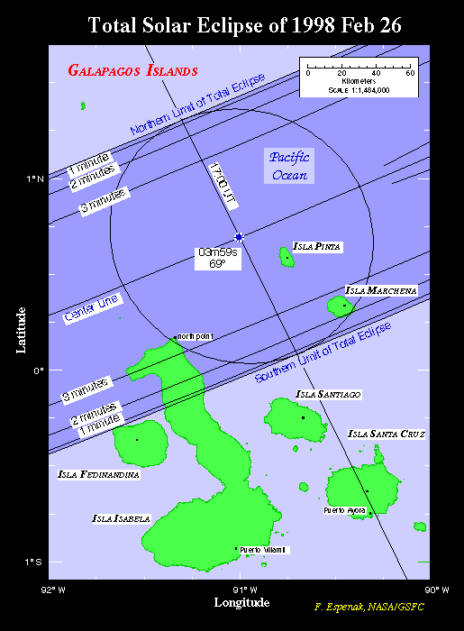
The Moon's umbral shadow first touches down on Earth just south of the equator in the Pacific Ocean about 3000 kilometers southeast of the Hawaiian Islands (15:46:45 UT). Even at this extreme position, the total eclipse lasts nearly one and a half minutes. For the first one and a quarter hours, the umbra sweeps across 5500 kilometers of open water while encountering no major bodies of land. First landfall finally occurs shortly after crossing north of the equator (16:56 UT) as the shadow rushes across several members of the Galápagos Islands. Maximum eclipse takes place shortly before noon with the Sun 69° above the horizon. Unfortunately, none of the islands are on the center line where the duration of totality is one second under four minutes (Figure 4). The northern third of Isla Isabela lies within the path and experiences a duration of 3 minutes 21 seconds along its north coast. Isla Pinta and Isla Marchena are also situated in the path, but all three islands are uninhabited wildlife sanctuaries with access strictly controlled by the Ecuadorian government.
After leaving the Galápagos, the umbral path continues on a northeastern course. The instant of greatest eclipse1 occurs at 17:28:23.2 UT about 600 kilometers west of Colombia's Pacific coast. At that moment, the length of totality reaches its maximum duration of 4 minutes 8 seconds, the Sun's altitude is 76°, the path width is 151 kilometers and the umbra's velocity is 0.592 km/s. The axis of the Moon's shadow passes closest to the center of Earth (gamma2 =0.239) at greatest eclipse.
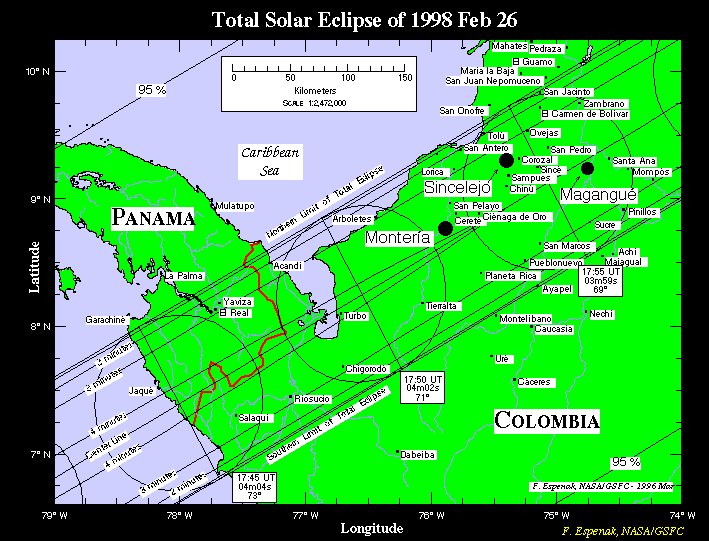
Fifteen minutes later (17:43 UT), the umbral shadow enters South America and follows the border between Panama and Colombia (Figure 5). Stretching across the Isthmus of Panama, the path crosses into northern Colombia where the center line duration drops below four minutes. In spite of a 25 second penalty for its position 20 kilometers north of the center line, the Colombian city of Valledupar still experiences a generous 3 minute 29 second total eclipse. After climbing the Andes, the path sweeps through northwestern Venezuela (Figure 6). The semi-desert vegetation of this region is a testament to its arid climate. Although Maracaibo lies 50 kilometers south of the center line, it manages to enjoy nearly three minutes of totality. The eclipse occurs here in the early afternoon with the Sun 65° above the horizon.
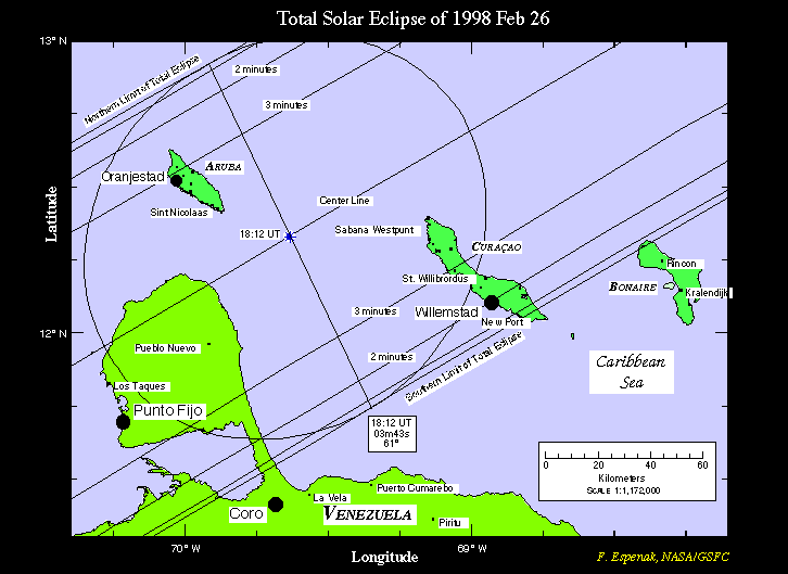
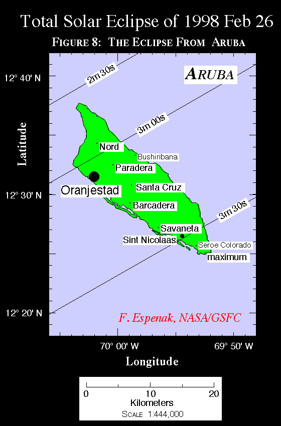
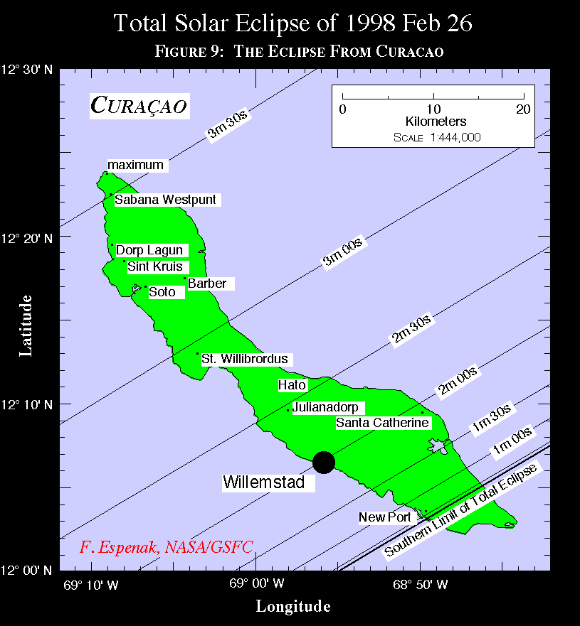
The Moon's shadow leaves Venezuela via the Peninsula de Paraguaná and sweeps across the Caribbean where it encounters five major islands of the Lesser Antilles. The center line passes directly between Aruba and Curaçao (Figure 7, Figure 8, and Figure 9), but both islands experience as much as 3 1/2 out of a possible 3 3/4 minutes of totality. Aruba's capital Oranjestad witnesses a 3 minute 6 second total phase while the duration in Willemstad, Curaçao is 1 minute 58 seconds. Both Netherlands Antilles islands make good locations for the eclipse since they share similarly promising weather prospects. Nearby Bonaire is just outside the 143 kilometer wide path although its northwestern coast will witness a grazing eclipse with perhaps a dozen seconds of totality.
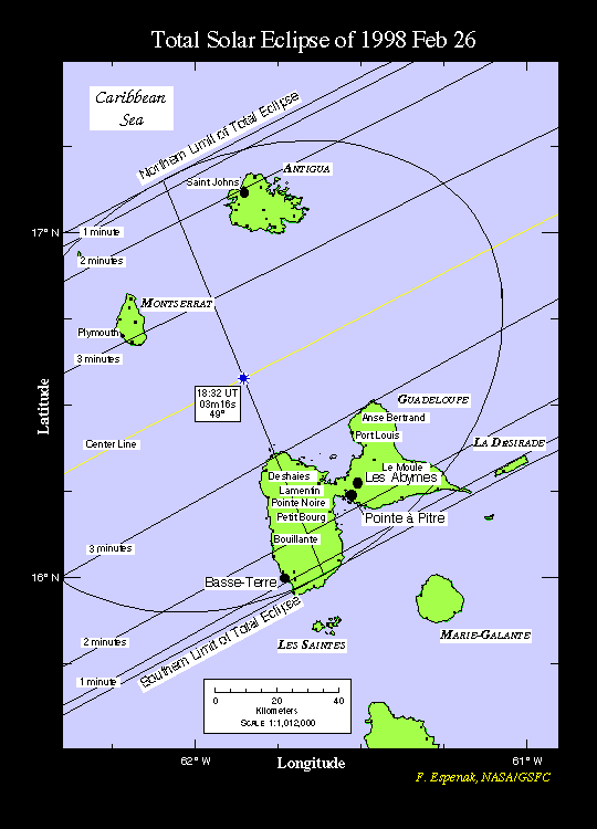
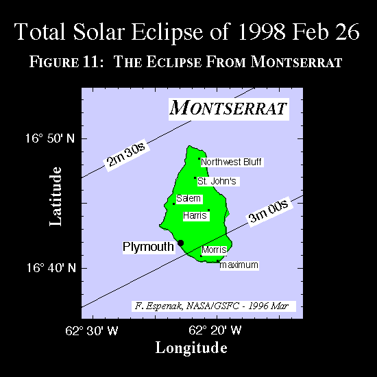
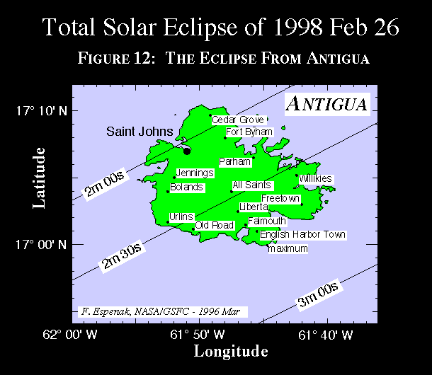
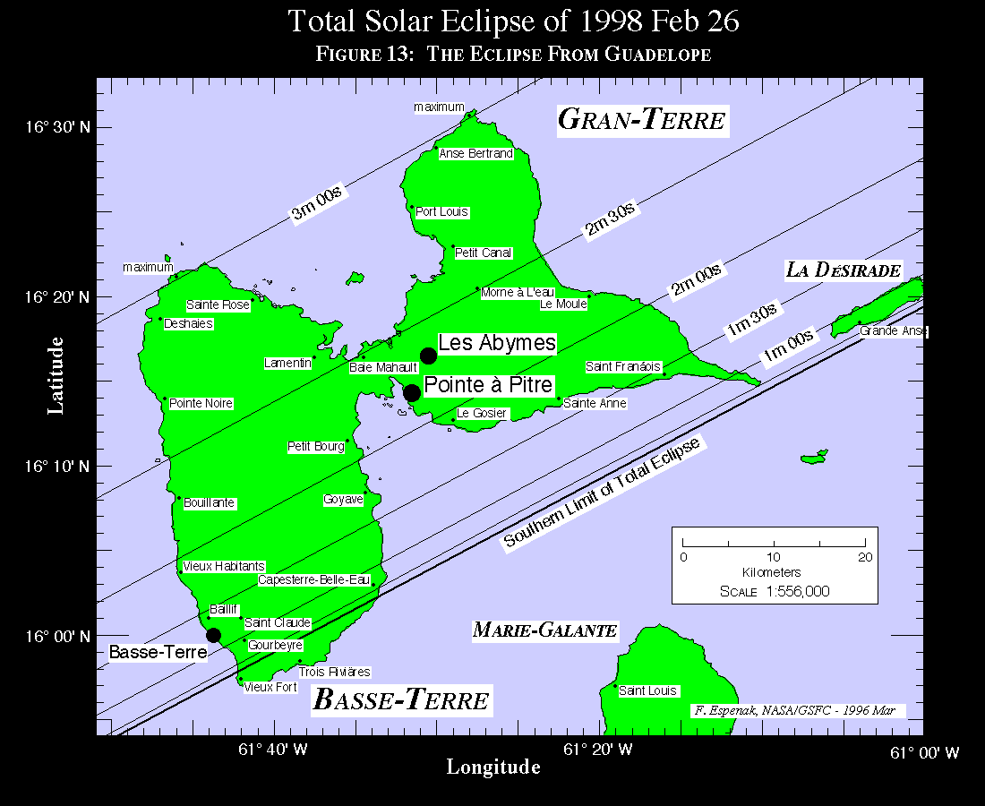
The track continues across the Caribbean where it engulfs the Leeward Islands (Figure 10) of Montserrat (Figure 11), Antigua (Figure 12) and Guadeloupe (Figure 13). Here, the umbra's velocity increases to over 0.9 km/s and the path width drops to 136 kilometers. Occurring in mid afternoon, the Sun's altitude is 49° at maximum eclipse. Although the center line passes between Guadeloupe and the other two islands, all locales enjoy as much as 3 out of a possible 3 1/4 minutes of totality. Since the southern extremes of Guadeloupe actually lie outside the umbral path, most observers will want to position themselves on the north and west coasts in order to experience the maximum duration possible. Nevertheless, some may choose a site several kilometers inside the southern limit in order to witness the prolonged views of Baily's Beads and chromosphere afforded by such locations. While not as promising as Aruba and Curaçao, the weather prospects of this region are still quite favorable.
Leaving the Caribbean Sea, the umbra races across the Atlantic towards Africa. About 1000 kilometers west of Morocco, the path ends along the sunset terminator as the shadow falls back into space (19:09:57 UT). Over course of 3 hours and 23 minutes, the Moon's umbra travels along an approximately 14000 kilometer long path and covers a region comprising 0.3% of Earth's surface.

1The instant of greatest eclipse occurs when the distance between the Moon's shadow axis and Earth's geocenter reaches a minimum. Although greatest eclipse differs slightly from the instants of greatest magnitude and greatest duration (for total eclipses), the differences are usually quite small.
2Minimum distance of the Moon's shadow axis from Earth's center in units of equatorial Earth radii.
Adapted from NASA RP 1398 "Total Solar Eclipse of 1998 February 26".

WebMaster: Fred Espenak Planetary Systems Branch - Code 693 e-mail: espenak@lepvax.gsfc.nasa.gov NASA/Goddard Space Flight Center, Greenbelt, Maryland 20771 USA
|
|---|