
|
|---|
|
|
|---|
Index to Australian Weather Prospects
The same features that control the weather along the eclipse track in Africa also operate in Australia, though the equatorial moisture is less important and the influence of the anticyclones is increased. In December the southern part of Australia is entering the sunniest time of year. For the eclipse observer there is a heavy penalty to be paid for these conditions, for the sun is very low, setting during the latter stages of the eclipse, and the eclipse duration is measured in seconds rather than minutes.
As in Africa, Australia's latitude places the eclipse track between the band of high pressure anticyclones that mark the sub-tropics and the equatorial low pressure belt that demarcate Earth's Intertropical Convergence Zone (ITCZ). In December the mean position of the anticyclones can be found close to its most southerly position, just south of the Australian continent. The descending air in the center of the anticyclones suppresses rain-bearing clouds and the south coast is in the early stages of its summer dry season. Farther inland along the eclipse track, in the desert climates of Queensland, New South Wales, and South Australia, rainfall has no pronounced dry or wet season and is generally light throughout the year.
The dry air in the center of the anticyclones does not extend all of the way to the surface, leaving room for low level moisture to gather. This moisture is typically found below a temperature inversion that inhibits vertical motion and so it is difficult to mix wet lower and dry higher level air and evaporate the cloudiness. Because they have only a small vertical extent, rain is uncommon from such clouds and an area may be cloudy and yet dry at the same time.
This position of the high-pressure belt to the south of the continent allows the tropical moisture from the ICZ to reach into northern Australia. Typically it is well away from the eclipse track but periodically it moves southward to play a prominent role in the weather over South Australia and southern Queensland. Solar heating is extremely high in northern parts of the continent, and a persistent heat low forms south of Port Hedland in Western Australia in response to the abundant sunshine. This Pilbara low is the Australian counterpart of the Botswana low. Its influence waxes and wanes with the flow of the weather, and occasionally strengthens sufficiently to cast a long low-pressure trough southward across the western continent where it plays a role in the formation of cloud and precipitation.
Ceduna, the first community on the track of the eclipse, lies at the edge of the Nullarbor Plain, a flat and infertile landscape that stretches along the Great Australian Bight. Ceduna is reached by the Eyre Highway, one of the world's loneliest roads, stretching 2400 kilometers from Adelaide to Perth. The town itself is a well-appointed popular resting space for long-distance travelers, offers fishing and whale watching, and for astronomers, the Ceduna Radio Observatory operated by the University of Tasmania. This 30-meter antenna is part of the Australian VLBI array.
Roads from Ceduna lead only a short distance inland and there is little opportunity to move if December 4 proves to be cloudy. The Eyre Highway and most local roads tend to run east-west, leaving very little room to maneuver on an eclipse track only 25 km wide. The only route along the center line is from Ceduna to Maltee, a distance of about 20 kilometers.
Farther northeast the eclipse track crosses Lake Gairdner National Park, a vast salt pan famous for the world land speed records that have been attempted and achieved on its flat surface. Nearby is Lake Hart, another blinding-white salt pan set in a red landscape, but this lake boasts the main launching pad for the Woomera Rocket Range on its northeast side, now no longer in use. Eclipse sites in this area, though convenient to reach by way of Highway 87 from Port Augusta to Alice Springs, will have to contend with the heat of the interior and the tireless Australian flies. The centerline lies very close to Koolymilka, though there seems to be little in the way of community any more at this former launching site.
A little farther along the track, is Roxby Downs, a thoroughly modern uranium-mining town (along with gold, silver and copper) with a turbulent history since its construction in 1986. It's close to the north edge of the track but could provide a convenient base. The surrounding area is more settled than the earlier part of the eclipse track, in large part because of the availability of water from artesian wells. In this area, the eclipsed sun will hang little more than 5 degrees above the horizon with a duration barely over a half-minute.
Beyond Roxby Downs, the eclipse track skirts the Flinders Ranges. Flinders Ranges National Park, south of the track, is one of the most majestic parks in Australia � an old folded landscape of gorges and craggy red mountains. Local Dreamtime stories tell of the serpent that guards the water holes and formed the Flinders' contours by wriggling north to drink dry the salt lakes.
Continuing northward, the shadow path moves past the Flinders Ranges and into the Sturt Desert. Touching the junction of three states, the track makes a brief passage through New South Wales and then into Queensland. The point where the three states meet is known as Cameron's Corner and the region is the Corner Country. By now, the Sun is very close to the horizon at mid-eclipse, reaching that point just beyond Old Tickalara. The path continues northeastward, right across Australia and into the Pacific Ocean, but gives watchers only a brief view of the eclipsed sun before it sets.
The Corner Country is a remote part of Australia, well into the Outback. Roads are not paved and are largely deserted. Travel requires food, extra fuel, water and spare parts. The area around Old Tickalara is very dusty; one traveler reports only three homesteads between Cameron's Corner and Thargomindah, a 340-km route that more-or-less follows the eclipse track and its extension northeastward.
The position and intensity of the subtropical anticyclones that migrate eastward across the Great Australian Bight control southern Australian weather. The pattern is very similar to that in Africa. As highs approach from the southwest, winds blow first from the southeast and then from the east. At least initially, the southeasterlies are onshore winds and frequently pile low-level clouds against the south shore. As the center of the high reaches the Bight, winds become more easterly and then northeasterly, drawing hot dry air out of the interior and dissipating the coastal clouds.
A low-pressure trough then follows, separating the departing high from the next in the sequence. This trough often contains a cold front, substantially modified after passage over the Bight, but containing enough moisture to create the relatively cloudy climate of coastal regions. Most of the cold front cloudiness does not penetrate far inland before it encounters the dry desert air of the interior and gradually dissipates. This is not an incontrovertible rule however, for the stronger systems are quite capable of pushing cloudy weather right across the length of the eclipse track as far as the Great Dividing Range. Southern Australia has a flat terrain that offers little physical impediment to weather moving in from the south.
The highs and troughs moving alternately past the continent bring a repeating pattern of cloud and sun, cool and hot weather. While the cycle from high to high or trough to trough has a modest degree of regularity (repeating at 5-6 day intervals), the weather in Australia is not a monotonous series of predictable events. Troughs vary in strength, some with fronts, some not. Highs may stall, bringing persistent weather for several weeks before moving on to allow the normal cycle to return. Departures from the average are common and bring weather that is far from average.
In northern Australia, cloud and precipitation are influenced by the Intertropical Convergence Zone that has moved southward onto the continent by December. The presence of the ITCZ signals the beginning of �the Wet�, a season of frequent and widespread showers and thundershowers. Moisture from the ITCZ can be induced to flow southward under the right conditions, but typically remains in northern regions away from the eclipse path.
One of the elements that may induce a southward excursion of the moisture is a strengthening in the Pilbara heat low. As the low intensifies, northerly winds increase and push tropical moisture southward across Western Australia. This moisture is typically caught by an inter-anticyclonic trough (with its cold front) and is turned eastward toward the center of the continent and the eclipse track. The combination of tropical moisture and the atmospheric dynamics of the trough can create a large area of broken cloud that may linger over the track for several days. The combined system often contains enough instability for showers and thunderstorms. Satellite photos show characteristic arched bands of cloud with this type of pattern that persist from their first appearance in the Bight until they pass Adelaide several days later.
The low may also be reinforced by a tropical cyclone moving onto the continent from the Indian Ocean, with dramatic consequences for cloud cover across much of the country. This is a relatively uncommon event, occurring only about once a year. On December 6, 2000, Tropical Cyclone Sam moved into northwestern Australia, joined the Pilbara low, and pushed a large area of cloud southward for the next five days. In what might be a good omen for this type of meteorological event, the cloud did not reach the south coast and only the northern part of the eclipse track was affected.
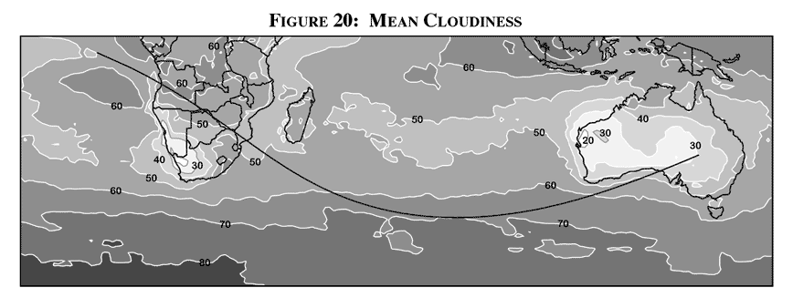
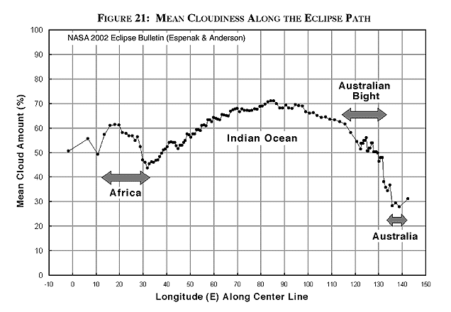
Figure 20 shows the regional distribution of mean daytime cloudiness along the eclipse track. This map is an average of November and December satellite observations combined to better represent the cloudiness around the eclipse date in early December. Because the satellite cloud statistics are derived from fixed algorithms, the results are free of many of the biases that are contained in human observations of cloud cover and form a better comparison of cloud prospects in Australia versus those in Africa. In Australia, coastal regions are the cloudiest and there is a gradual drying along the track inland, at least as far as the Queensland-New South Wales border. The improvement is substantial � there are more than twice as many sunny days in the interior as on the coast. Figure 21 is derived from the satellite data in Figure 20 and graphs the cloud cover along the centerline in more detail.
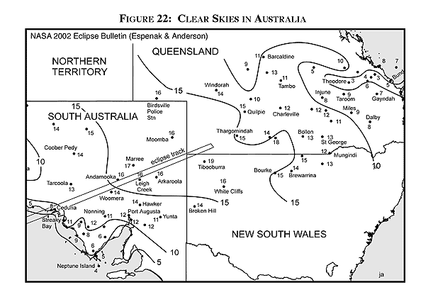
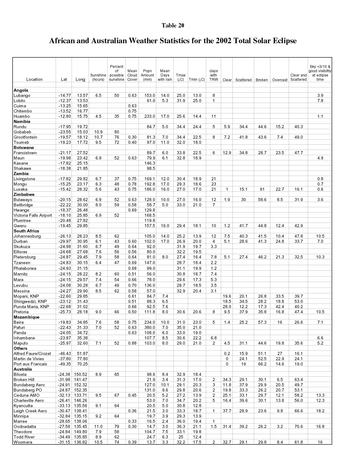
Figure 22 shows contours of the number of clear days in December based on surface observations of cloud cover from Australian weather stations. The frequency of clear days increases from 8 to 11 days per month at Ceduna where the eclipse track first reaches land, to 19 days at the end of the track where the sun sets at mid eclipse. Values for the percent of possible sunshine ( Table 20) reach almost 80% at Oodnadatta, and nearly 75% at Woomera � statistics 10 to 15 percent better than the best in Africa. While Australia quite clearly has sunnier weather, the low altitude of the sun will require a nearly clear horizon in order for the eclipse to be seen. This is a much more stringent requirement than a low frequency of cloud cover at midday and the choice of Australia versus Africa will be a tough one to make.
The seasonal frequency of completely clear skies at sunset ranges from 15 to 35 percent ( Table 20) with the larger amount inland. Scattered cloudiness (up to half of the sky covered) will bring a modest probability that the horizon will be obscured. Some of this cloud will be convective and will dissipate as the Sun approaches the horizon and temperatures fall, but this cannot be counted on if a cold front has made a recent passage through the area. Larger cloud amounts, when more than half the sky is covered, will bring progressively slimmer chances of seeing the eclipse. If we make the reasonable assumption that there is a one-third chance that scattered cloud will block the Sun and a two-thirds chance for broken cloud, then the chances of seeing the eclipse on December 4 will range from about 55% on the coast to about 65% inland. All in all, the prospects for a successful horizon eclipse in Australia likely exceed the best chances in Africa by about five to eight percent. To achieve this advantage, a site inland from the coast must be selected.
Temperatures in the interior of Australia can become very hot � similar to those encountered in southern Turkey during the 1999 eclipse. Daytime highs ( Table 20) average in the low to mid 30's Celsius (90's F), and records climb into the mid and upper 40's Celsius (100's F). Cooler readings prevail along the coast where sea breezes cut off the daytime heating and bring pleasant relief.
Departing anticyclones bring hot northerly winds and coastal regions can see temperatures nearly as great as the interior. In due course, another high-pressure system will approach from the west and winds will turn to the south. This brings temperate ocean air inland, resulting in an abrupt drop in temperature known as a �cool change.� A 10� Celsius change in 30 minutes is typical and 20� Celsius is possible.
Though the eclipse occurs while temperatures are falling after the daytime high, equipment set-up will take place at the hottest time of day. Temperatures in the forties occur two or three times on average each month at inland sites. Readings this high require great caution, for heat stroke is a very real possibility. Plenty of water, misters, hats, a slow pace and occasional refuge in shade would be well advised, along with emergency plans if the heat should prove overpowering. Equipment also suffers in such heat and planning should include provision for cameras and telescopes. It is worth noting that official temperature measurements are made in the shade and readings in full sunlight are much higher.
Along the eclipse track, December rainfall is much lighter in Australia than in Africa. For the most part, monthly accumulations range from 10 to 20 mm. Table 20 shows larger amounts farther east along the extension of the eclipse track (where a short total eclipse may only be seen in the seconds before sunset). This precipitation is found along the Great Dividing Range where terrain and the influence of the Pacific Ocean hold sway. Thundershowers are uncommon, occurring only one or two days of the month.
Winds favor the southerly quadrant along the eclipse path, especially along the coast where a daily sea breeze is common. At Ceduna, 81% of the 6 PM winds are over 20 knots (37 km/h). Inland at Woomera the frequency declines to 46%. These are substantial winds and will demand some accommodation by the eclipse observer, either to seek a little protection or to anchor equipment to reduce vibrations. At the least, observers with sensitive equipment should seek a site at least a few kilometers inland (and 20 to 40 would be better) to take advantage of the decrease in windiness away from the open coast.
The daily sea breezes have long been recognized as a distinctive feature of the local climatology and are given popular local names such as Eucla Doctor, Albany Doctor or Fremantle Doctor. Sea breezes arise because of the temperature difference between the land and the water; the hot air inland rises, drawing air from the cooler South Australian Bight onshore. Sea breezes typically begin in mid-morning along the coast, but the onset can be delayed or even prevented if opposing winds driven by a larger weather system hold them at bay. Depending on the time of onset and the help or hindrance of prevailing winds, sea breezes may extend as far as two or three hundred kilometers inland where they bring a pleasing drop in temperature and an increase in humidity. The effect of the eclipse on these winds will be an interesting observation, as will their effect on shadow bands.
Dust is an unpleasant component of any strong wind in Australia as the dry interior provides a ready supply of material. The initial gust that signals the arrival of the sea breeze is often very strong and then dies quickly to a steadier and lighter flow. Under such circumstances, it may be sufficient to protect equipment for only a short period, but a lingering dust haze may impede the view to the setting sun.
Dust devils, a whirling column of dust, are also common in Australia in the dry season and contribute to the general haziness of the atmosphere. Some can become quite strong and lift a considerable quantity of dirt into the air. Dust storms are also legendary in the country, being driven by particularly strong cold fronts or by the outflow from strong thunderstorms.
The best weather prospects for viewing the eclipse will be found inland. Cloud cover is at its lowest from the vicinity of Woomera eastward to the end of the track. The higher solar elevation on the coast is not likely to compensate for the greater amount of cloud, leaving the adventurer with a hot and dusty, but ultimately sunnier inland location for best circumstances. Temperatures could be very high and suitable precautions should be taken to protect from heat stroke.
Save for the fact that the eclipse occurs at sunset, Australia would be an easy choice over Africa if weather were the only factor to be considered when selecting a viewing site.
Adapted from Adapted from NASA TP 2001-209990 "Total Solar Eclipse of 2002 December 04."
Permission is freely granted to reproduce this information and data when accompanied by an acknowledgment of the source:
"From Total Solar Eclipse of 2002 December 04 by Fred Espenak and Jay Anderson, NASA"

WebMaster: Fred Espenak Planetary Systems Branch - Code 693 e-mail: espenak@gsfc.nasa.gov NASA/Goddard Space Flight Center, Greenbelt, Maryland 20771 USA
|
|---|