|
|---|
|
|
|---|
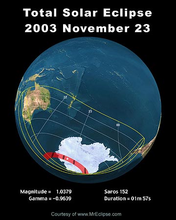
On Sunday, 2003 November 23, a total eclipse of the Sun will be visible from within a narrow corridor which traverses the far Southern Hemisphere. The path of the Moon's umbral shadow begins in the Indian Ocean, and quickly sweeps over portions of Antarctica. A partial eclipse will be seen within the much broader path of the Moon's penumbral shadow, which includes most of Australia and New Zealand, southernmost South America, and all of Antarctica.This web site has been established for the purpose of providing detailed predictions, maps, figures and information about this important event. The material here is adapted from the NASA Technical Publication "Annular and Total Solar Eclipses of 2003" (NASA/TP-2002-211618). This publication was published in 2002 November and is now available for distribution. It is part of NASA's official eclipse bulletin publication series. Instructions and a form for ordering a hard copy of this publication can be found at:
Order Form for NASA Eclipse Bulletins For a brief report on this event, see Eclipses During 2003.
Additional and supplemental material for the 2003 eclipse will be published here in the coming months.
The following links give detailed descriptions and explanations of the 2003 total eclipse maps, tables and predictions.
- 2.01 - Introduction
- 2.02 - Path of Totality
- 2.03 - Orthographic Map of the Nov. 23 Eclipse Path
- 2.04 - Stereographic Map of the Nov. 23 Eclipse Path
- 2.05 - Detailed Maps of the Path of Totality
- 2.06 - Elements, Shadow Contacts and Nov. 23 Eclipse Tables
- 2.07 - Local Circumstances Tables for Nov. 23
- 2.08 - Lunar Limb Profile for Nov. 23
- 2.09 - Sky During Totality
This information is adapted from NASA Technical Publication "Annular and Total Solar Eclipses of 2003" (NASA/TP-2002-211618).
The following maps show the overall regions of visibility of the partial eclipse as well as the path of the total eclipse through Antarctica. They use high resolution coastline data from the World Data Base II (WDB). Each map was chosen to isolate a specific region along the land portion of the eclipse path. Curves of maximum eclipse are included as well as the outline of the umbral shadow. Current Antarctica research stations are plotted to show their positions with respect to the path of totality.
Each map is available in two resolutions: 'Low' (web resolution) and 'High' (300 dpi print resolution). You may need to set your printer to 25% reduction in order to print 'High' resolution figures on a single page.
| Figure Number | Title/Description | Low Resolution | High Resolution |
|---|---|---|---|
| Figure 2.1 | Orthographic (Global) Map of 2003 Total Solar Eclipse | Low | High |
| Figure 2.2 | Stereographic Map of 2003 Total Solar Eclipse | Low | High |
| Figure 2.3 | 2003 Total Eclipse Path Through Antarctica | Low | High |
These figures are adapted from NASA Technical Publication "Annular and Total Eclipses of 2003".
The following tables give detailed predictions including the Besselian Elements, shadow contacts with Earth, path of the umbral shadow and topocentric data (with path corrections) along the path. Also included are special extended version tables of path coordinates and graze zones in formats convenient for plotting on maps.
| Figure Number | Title/Description | Low Resolution | High Resolution |
|---|---|---|---|
| Figure 2.4 | Lunar Limb Profile for November 23 at 22:40 UT | Low | High |
| Figure 2.5 | Sky During Totality as Seen From Central Line at 22:40 UT | Low | High |
The following tables give detailed local circumstances for ~140 cities and locations in Antarctica, Australia, New Zealand and South America. These tables give the local circumstances at each contact and at maximum eclipse for every location. The coordinates are listed along with the location's elevation (meters) above sea-level, if known. The Universal Time of each contact is given to a tenth of a second, along with position angles P and V and the altitude of the Sun. The position angles identify the point along the Sun's disk where each contact occurs and are measured counter-clockwise (i.e., eastward) from the north and zenith points, respectively. Locations outside the umbral path miss the umbral eclipse and only witness first and fourth contacts.
- Detailed Explanation of Local Circumstance Tables
- Table 2.6 - Eclipse Circumstances for Antarctica
- Table 2.7 - Eclipse Circumstances for Argentina, Chile, and Falkland Islands
- Table 2.8 - Eclipse Circumstances for Australa
- Table 2.9 - Eclipse Circumstances for New Zealand
- Local Circumstances Eclipse Calculator - Calculate eclipse circumstances for any location or city (courtesy of Chris O'Byrne.
The following links give detailed information about the weather prospects for the 2003 total solar eclipse.
- 2.10 - Introduction to Weather Prospects for November 23
- 2.11 - Weather Patterns
- 2.12 - Coast of Queen Mary Land - Mirny
- 2.13 - Interior of Antarctica
- 2.14 - Coast of Queen Maud Land - Maitri, Neumayer, and Novolazarevskaja
- 2.15 - Selecting a Site
- 2.16 - Weather Web sites for November 23 Total Eclipse
- Table 2.11 - Antarctic Station Climatology
- Key to Table 2.11
| Figure Number | Title/Description | Low Resolution | High Resolution |
|---|---|---|---|
| Figure 2.6 | Cloud Satistics for Three Stations | Low | High |
This information is adapted from NASA Technical Publication "Annular and Total Solar Eclipses of 2003" (NASA/TP-2002-211618).
In November 2003, links will appear which will provide live web coverage of the eclipse (if any are available).
Permission is freely granted to reproduce this information and data when accompanied by an acknowledgment of the source:"Eclipse predictions (maps) courtesy of Fred Espenak, NASA/GSFC" If you have comments, suggestions, corrections and/or additions, please send them (along with the URL address of this page) to Fred Espenak
Special thanks to National Space Club summer intern Lauren Williams for her valuable assistance in preparing this web page. (July 2003)

Eclipse Predictions & WebMaster: Fred Espenak e-mail: espenak@gsfc.nasa.gov Official NASA Representative: Dr. Drake Deming
Planetary Systems Branch - Code 693
|
|---|