Total Solar Eclipse of 2017 August 21
On 2017 August 21, a total eclipse of the Sun is visible from within a narrow corridor that traverses the United States of America. The path of the Moon's umbral shadow begins in northern Pacific and crosses the USA from west to east through parts of the following states: Oregon, Idaho, Montana, Wyoming, Nebraska, Kansas, Iowa, Missouri, Illinois, Kentucky, Tennessee, North Carolina, Georgia, and South Carolina (note: only a tiny corner of Montana and Iowa are in the eclipse path). The Moon's penumbral shadow produces a partial eclipse visible from a much larger region covering most of North America.
Main NASA site for this eclipse
Path of the 2017 Total Solar Eclipse
(click to enlarge)
This special web page contains preliminary information about the 2017 total eclipse of the Sun. It will be updated with more information as eclipse day approaches.
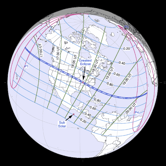
Orthographic Map of the Total Solar Eclipse
The following map shows the overall regions of visibility of the partial eclipse as well as the path of the Total eclipse through the USA. It uses coastline data from the World Data Base II (WDB).
- Orthographic Map of 2017 Total Solar Eclipse (gif)
- Orthographic Map of 2017 Total Solar Eclipse (pdf)
Interactive Map of the Path of Totality
An implementation of Google Map has been created which includes the central path of the 2017 total solar eclipse. This allows the user to select any portion of the path and to zoom in using either map data or Earth satellite data.
Other interactive eclipse maps include those by Xavier Jubier and Bill Kramer.
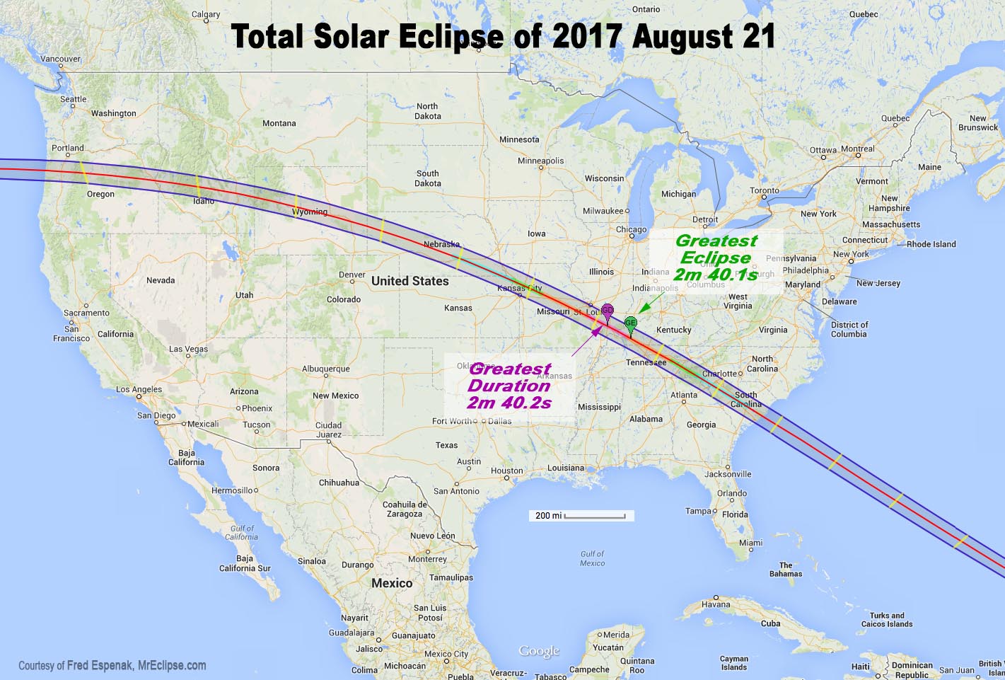
Path of the 2017 Total Eclipse through the USA
(click to enlarge)
Maximum Detail Maps of the Path of Totality
The following maps show the path of the 2017 total solar eclipse in maximum detail for the United States and by state. Within the path of totality, curves of constant duration have been plotted for the total phase. Note that the constant duration curves are calculated using the exact shape of the Moon. Mountains and valleys can shorten or lengthen the duration of totality by 1-3 seconds. The maps also include the general terrain highlighting major towns, cities, and highways.
These maximum detail maps were prepared by Michael Zeiler (Esri) using a high level CAD/GIS (Computer Aided Drawing / Graphic Information System) with data provided by Fred Espenak (NASA/GSFC) and Xavier Jubier. These poster-size maps can be saved to your computer for printing. You will have to scale the print size in your printer dialog to fit them to the page size you are printing.
| Map Number | Title/Description | Map File |
| Map 1 | Hemispheric view of the total solar eclipse | JPG |
| Map 2 | Total solar eclipse over the United States | JPG |
| Map 3 | Total solar eclipse over Oregon | JPG |
| Map 4 | Total solar eclipse over Idaho | JPG |
| Map 5 | Total solar eclipse over Wyoming | JPG |
| Map 6 | Total solar eclipse over Nebraska and Kansas | JPG |
| Map 7 | Total solar eclipse over Kansas, Missouri and Illinois | JPG |
| Map 8 | Total solar eclipse over Kentucky, Tennesse, and North Carolina | JPG |
| Map 9 | Total solar eclipse over South Carolina and Georgia | JPG |
Weather
- Weather Prospects and Maps - eclipse meteorologist Jay Anderson
Eclipse Photography
2017 Eclipse Links
Reproduction of Eclipse Data
All eclipse calculations are by Fred Espenak, and he assumes full responsibility for their accuracy. Permission is freely granted to reproduce this data when accompanied by an acknowledgment:
"Eclipse Predictions by Fred Espenak, NASA GSFC Emeritus"
For more information, see: NASA Copyright Information
