
|
|
|---|
![]()
To Be Published in Observer's Handbook 2002, Royal Astronomical Society of Canada
![]()
During the year 2002, two solar and three penumbral lunar eclipses occur as follows:
2002 May 26: Penumbral Lunar Eclipse
2002 Jun 10: Annular Solar Eclipse
2002 Jun 24: Penumbral Lunar Eclipse
2002 Nov 20: Penumbral Lunar Eclipse
2002 Dec 04: Total Solar Eclipse
Predictions and maps for the solar and lunar eclipses are presented in a number of figures linked to this document. World maps show the regions of visibility for each eclipse. The lunar eclipse diagrams also include the path of the Moon through Earth's shadows. Contact times for each principal phase are tabulated along with the magnitudes and geocentric coordinates of the Sun and Moon at greatest eclipse.
All times and dates used in this publication are in Universal Time or UT. This astronomically derived time system is colloquially referred to as Greenwich Mean Time or GMT. To learn more about UT and how to convert UT to your own local time, see Time Zones and Universal Time.
2002 May 26: Penumbral Lunar Eclipse
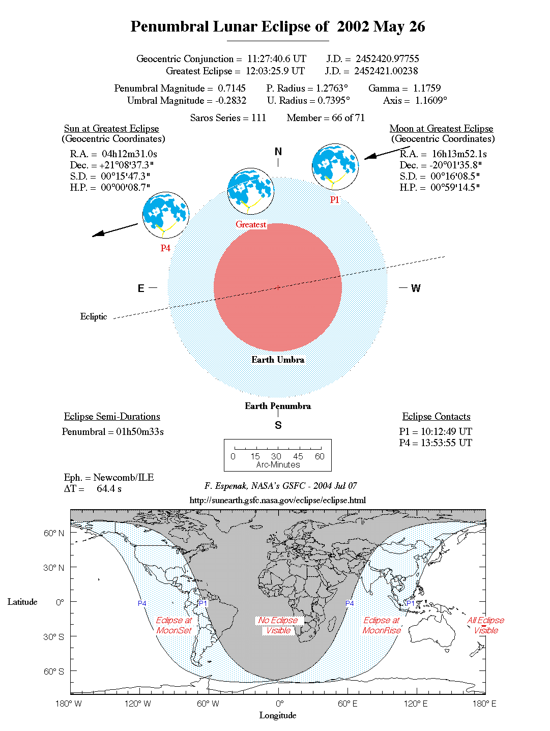
The first eclipse of the year is a deep penumbral lunar eclipse visible from parts of the Western Hemisphere. First and last penumbral contacts occur at 10:13 UT and 13:54 UT, respectively. The Moon's path through Earth's penumbra as well as a map showing worldwide visibility of the event is shown in Figure 1.
Greatest eclipse occurs at 12:03 UT with a maximum penumbral eclipse magnitude of 0.7145. Observers will note subtle yet distinct shading across the southern portions of the Moon. The Moon's southern limb actually lies 9.1 arc-minutes north of the umbra at its closest approach.
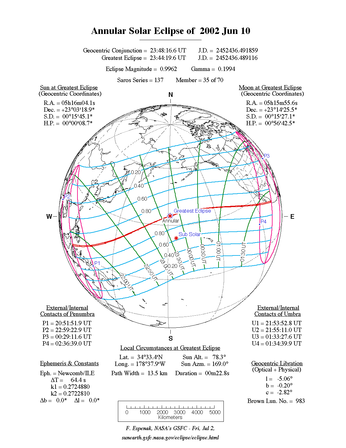
The first solar eclipse of 2002 is annular with a path that stretches the breadth of the Pacific Ocean. The partial phases are visible from eastern Asia and most of North America except for the northeast (Figure 2).
The Moon's antumbral shadow first touches down on Earth at 20:53 UT along the north coast of Sulawesi. Racing across the Celebes Sea, the antumbra engulfs the Indonesian islands of Pulau Sangihe and Kepulauan Talaud. The annular phase lasts just over one minute with the early morning Sun 6° above the horizon.
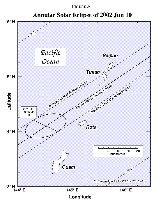
Leaving Indonesia, the shadow's trajectory takes it over a long track across the Pacific. As it does so, the curvature of Earth's surface causes the path width and central duration to gradually decrease. The antumbra reaches the southern end of the Northern Mariana Islands chain at 22:10 UT (Figure 3). Guam lies just 40 kilometres south of the 47 kilometre wide path and will experience a deep partial eclipse of magnitude 0.975. About 180 kilometres northeast of Guam, the islands Saipan and Tinian span the northern limit of the annular track. Tinian's southern tip extends a dozen kilometres into the path but still falls 10 kilometres short of the center line. Nevertheless, most of the 53 second long annular phase of magnitude 0.988 will be seen from this location with the Sun 32° above the horizon.
From this point on, the antumbra encounters no other populated islands across the Pacific. Greatest eclipse occurs at 23:48:15 UT about 2600 kilometres northwest of the Hawaiian Islands. The duration of the annular phase lasts a scant 23 seconds, but the event takes place in open ocean with no landfall in sight.
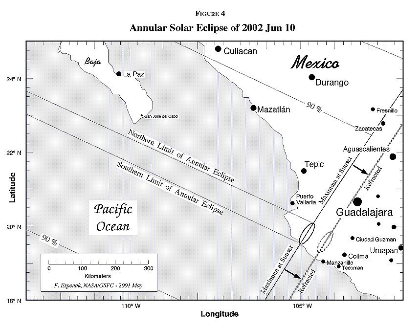
As the track begins to swing to the southeast, its width and central duration begin to increase once again but no other islands lie in its path. Just before reaching its terminus, the antumbra passes 50 kilometres south of the southern tip of Baja, Mexico at 01:32 UT (June 11) (Figure 4). In the final seconds of its earthbound trajectory, the shadow reaches the Pacific coast of Mexico, 30 kilometres south of Puerto Vallarta. Under favorable weather conditions, observers on the center line will witness a spectacular ring of fire on the horizon as the Sun sets just after annularity. The central duration is 1 minute 7 seconds and the magnitude is 0.981. Atmospheric refraction will actually displace the end of the path to the southeast so that the entire annular phase will occur before sunset for observes on or near the coast.
The antumbral shadow leaves Earth's surface at 01:35 UT (June 11). Over the course of 3 hours and 47 minutes, the Moon's antumbra travels along a path approximately 14,700 kilometres long and covering 0.2% of Earth's surface area. Path coordinates and centreline circumstances are presented in Table 1.
Partial phases of the eclipse are visible from much of North America, the Pacific and western Asia. Local circumstances for a number of cities are listed in Table 2. All times are given in Universal Time. The Sun's altitude and azimuth, the eclipse magnitude and obscuration are all given at the instant of maximum eclipse. Additional information is also available at the 2002 annular solar eclipse web site:
http://eclipse.gsfc.nasa.gov/SEmono/ASE2002/ASE2002.html
2002 Jun 24: Penumbral Lunar Eclipse
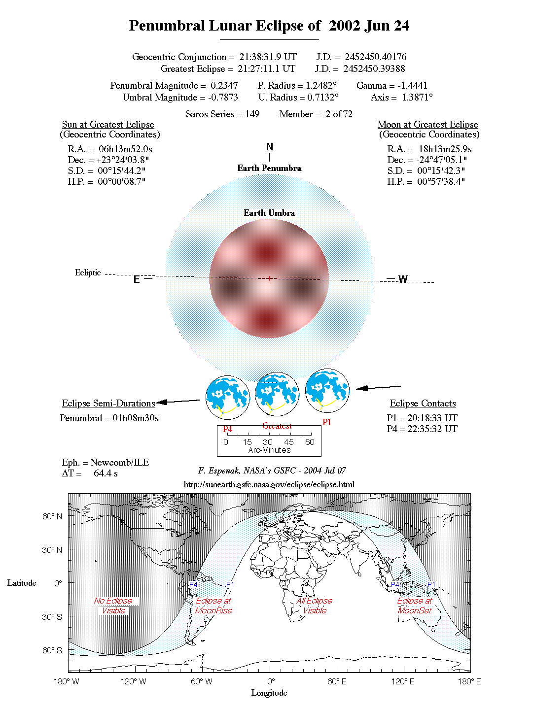
The year's second lunar eclipse follows two weeks after the annular solar eclipse. Unfortunately, the event is a very shallow penumbral eclipse which is nominally visible from the Eastern Hemisphere. First and last penumbral contacts occur at 20:19 UT and 22:36 UT, respectively.
Greatest eclipse takes place at 21:27 UT with a maximum penumbral eclipse magnitude of only 0.2347. At that time, the Moon's northern limb will dip a meager 7.4 arc-minutes into the pale penumbral shadow. Such a minor eclipse will be all but invisible, even for the sharpest eyed observers. The following Figure shows the Moon's path through the penumbral shadow and the region of global visibility.
2002 Nov 20: Penumbral Lunar Eclipse
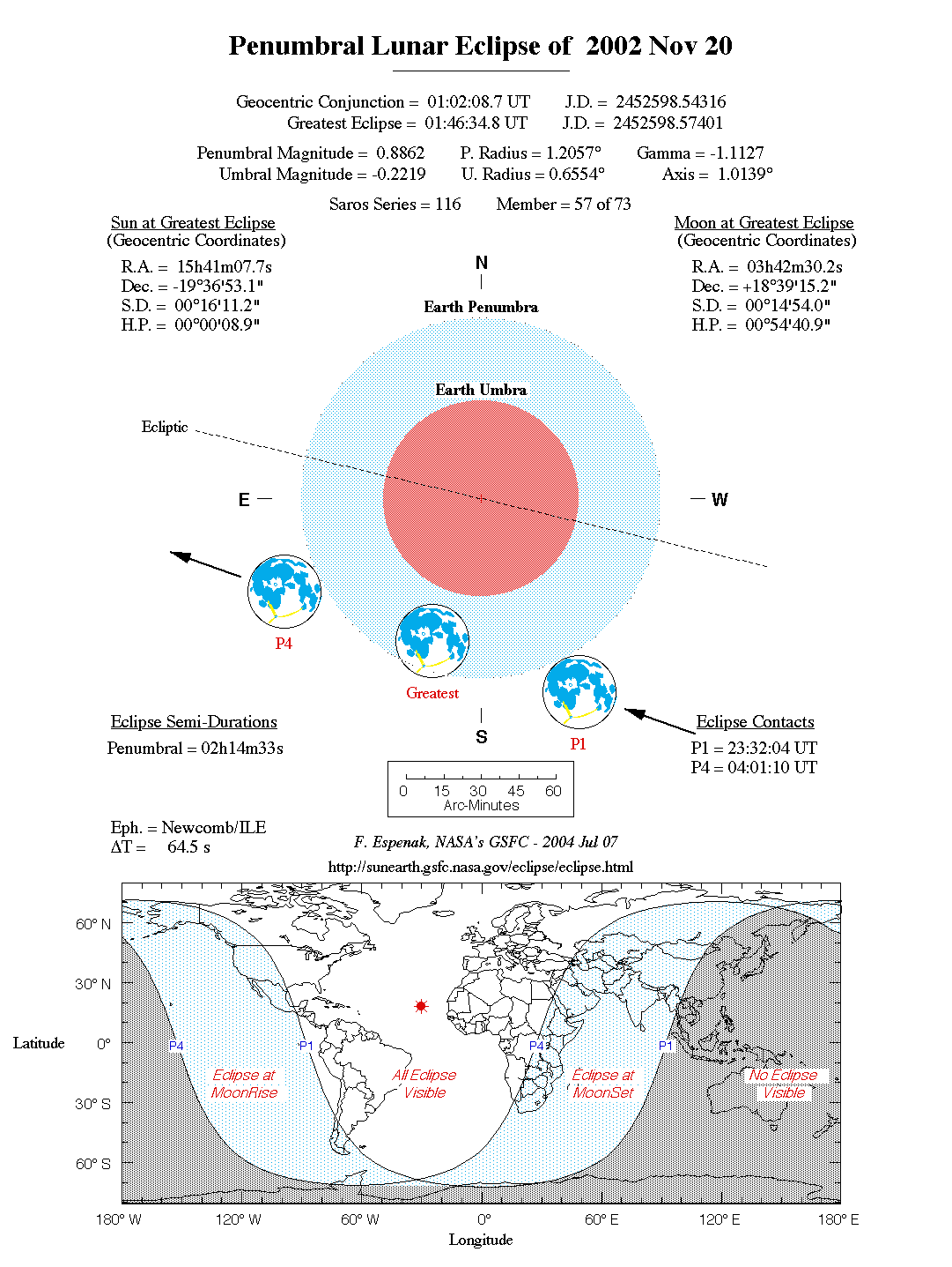
The last penumbral lunar eclipse of 2002 is also the deepest lunar eclipse of the year. The event will be observable from the Americas, Europe, Africa and central Asia. First and last penumbral contacts occur at 23:32 UT (Nov 19) and 04:01 UT (Nov 20), respectively. The Moon's path through Earth's penumbra and a map depicting worldwide visibility is shown in Figure 5.
At greatest eclipse (01:47 UT), the penumbral magnitude reaches its maximum value of 0.8862 as the Moon's northern limb passes just 6.6 arc-minutes from the edge of the umbra. Observers should be able to see a subtle yet distinct shading across the northern portion of the Moon's disk. Alas, the striking colors present during total eclipses will be absent from this event. We must wait until 2003 when two total lunar eclipses take place.
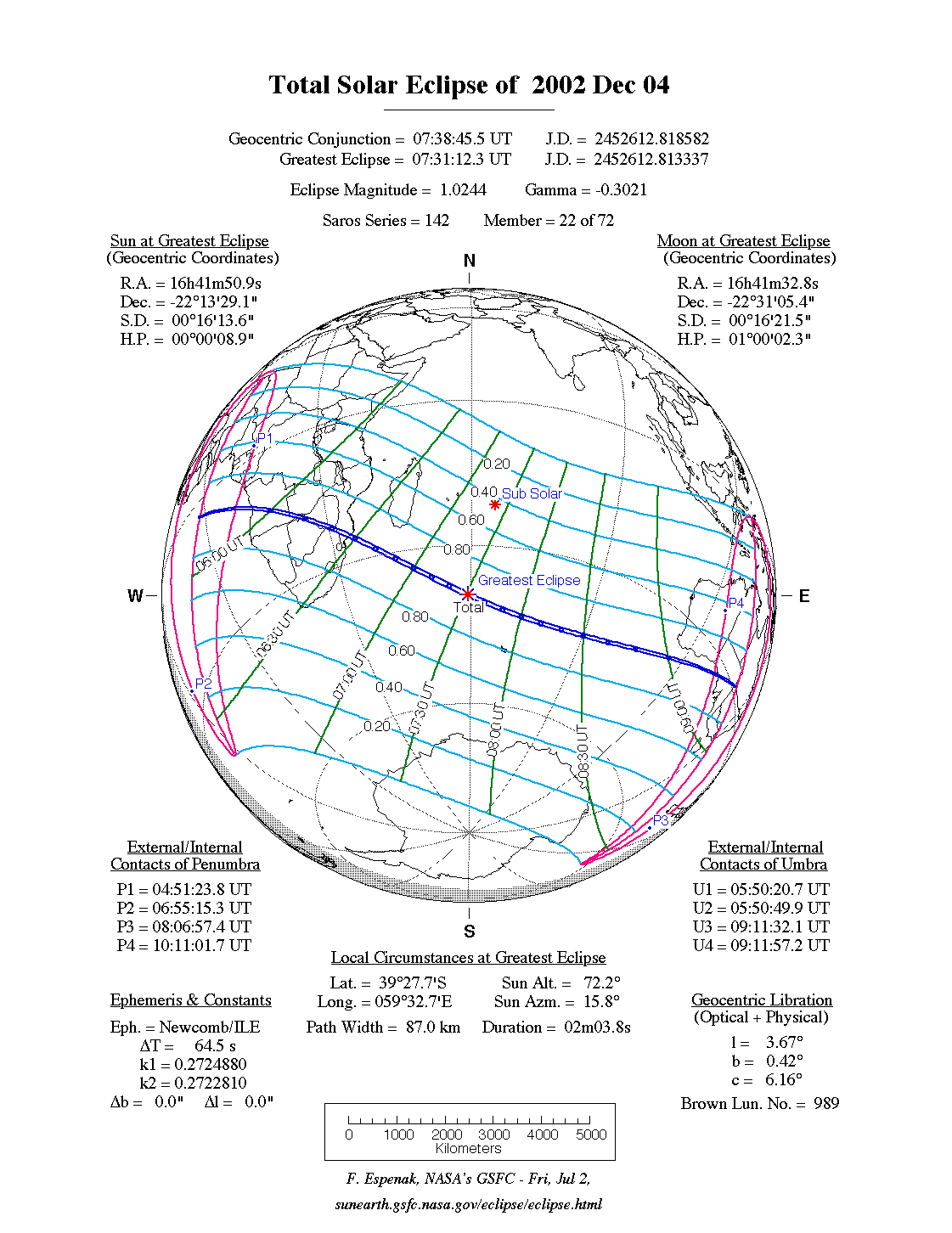
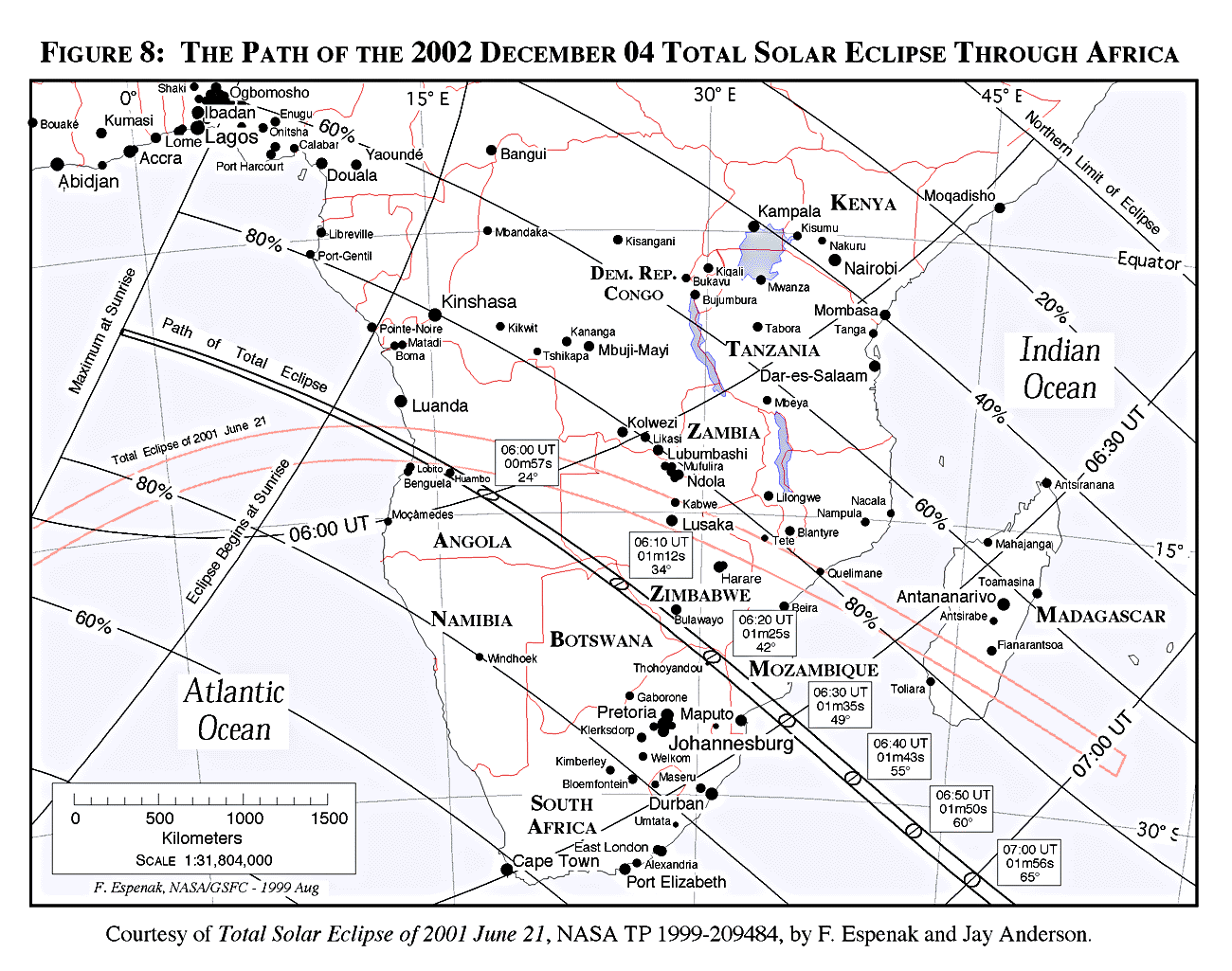
The final event of the year is a total solar eclipse visible from a narrow corridor that traverses the Southern Hemisphere. The path of the Moon's umbral shadow begins in the South Atlantic, crosses southern Africa and the Indian Ocean and ends at sunset in southern Australia. A partial eclipse will be seen within the much broader path of the Moon's penumbral shadow, which includes most of Africa, western Australia and Antarctica (Figure 6).
The eclipse begins in the South Atlantic where the Moon's umbral shadow first touches down on Earth at 05:50 UT (Figure 7). Along the sunrise terminator, the duration is only 26 seconds as seen from the centre of the 31 kilometre wide path. Seven minutes later, the umbra reaches the Atlantic coast of Angola (05:57 UT). Quite coincidentally, the first track of Angolan land to experience totality was also within the path of the total solar eclipse of 2001 June 21. The local residents are indeed fortunate to witness a total eclipse twice within the span of eighteen months.
The early morning eclipse lasts 51 seconds from the center line with the Sun 19° above the horizon. The umbra carves out a 50 kilometre wide path as it sweeps across Angola in a southeastern direction. Briefly straddling the Angola/Zambia border, the shadow crosses eastern Namibia before entering northern Botswana (06:09 UT). The path width has grown to 60 kilometres and totality lasts 1 minute 11 seconds. Following the political boundary between Zimbabwe and Botswana, the umbra travels with a ground speed of 1.2 km/s. Bulawayo, Zimbabwe lies just north of the track and its residents witness a deep partial eclipse of magnitude 0.987 at 06:14 UT.
The umbra crosses completely into Zimbabwe before entering northern South Africa at 06:19 UT. One minute later, the northern third of Kruger National Park is plunged into totality which lasts 1 minute 25 seconds as the hidden Sun stands 42° above the horizon. Quickly crossing southern Mozambique, the shadow leaves the dark continent at 06:28 UT and begins its long trek across the Indian Ocean.
The instant of greatest eclipse occurs at 07:31:11 UT when the axis of the Moon's shadow passes closest to the centre of Earth (gamma = -0.302). The length of totality reaches its maximum duration of 2 minutes 4 seconds, the Sun's altitude is 72°, the path width is 87 kilometres and the umbra's velocity is 0.670 km/s. Unfortunately, the umbra is far at sea ~2000 kilometres southeast of Madagascar.
During the next hour and a half, no land is encountered as the eclipse track curves to the northeast and begins to narrow. In the final ninety seconds of its terrestrial trajectory, the umbra traverses South Australia. The coastal town of Ceduna lies at the center of the 35 kilometre wide path. Totality lasts 33 seconds while the Sun stands 9° above the western horizon. The accelerating ground speed of the umbra already exceeds 5 km/s. In the remaining seconds, the increasingly elliptical shadow sweeps across 900 kilometres of the Australian Outback.
The umbra leaves Earth's surface at the sunset terminator at 09:12 UT. Over the course of 3 hours and 21 minutes, the Moon's umbra travels along a path approximately 12,000 kilometres long and covering 0.14% of Earth's surface area. Path coordinates and centreline circumstances are presented in Table 3.
Local circumstances for cities throughout the path are given in Table 4. All times are given in Universal Time. The Sun's altitude and azimuth, the eclipse magnitude and obscuration are all given at the instant of maximum eclipse.
A detailed report on this eclipse is available from NASA's Technical Publication series (see: NASA Solar Eclipse Bulletins). Additional information is also available at the 2002 total solar eclipse web site:
http://eclipse.gsfc.nasa.gov/SEmono/TSE2002/TSE2002.html
1The instant of greatest eclipse occurs when the distance between the Moon's shadow axis and Earth's geocenter reaches a minimum. Although greatest eclipse differs slightly from the instants of greatest magnitude and greatest duration (for total eclipses), the differences are usually quite small.
2Minimum distance of the Moon's shadow axis from Earth's center in units of equatorial Earth radii.
             h  = 15 (GST + UT - ra ) + l
             a  =  ArcSin  [ Sin d Sin f + Cos d Cos h Cos f ]
             A  =  ArcTan  [ - (Cos d Sin h) / (Sin d Cos f -  Cos d Cos h Sin f) ]

     where:
             h  =  Hour Angle of Sun or Moon
             a  =  Altitude
             A  =  Azimuth
           GST  =  Greenwich Sidereal Time at 0:00 UT
            UT  =  Universal Time
            ra  =  Right Ascension of Sun or Moon
             d  =  Declination of Sun or Moon
             l  =  Observer's Longitude (East +, West -)
             f  =  Observer's Latitude (North +, South -)
During the eclipses of 2002, the values for GST and the geocentric Right Ascension and Declination of the Sun or the Moon (at greatest eclipse) are as follows:
      Eclipse               Date           GST         ra         d

     Penumbral Lunar     2002 May 26     16.259     16.231    -20.027
     Annular Solar       2002 Jun 10     17.277      5.268     23.055
     Penumbral Lunar     2002 Jun 24     18.191     18.224    -24.785
     Penumbral Lunar     2002 Nov 20      3.928      3.708     18.654
     Total Solar         2002 Dec 04      4.863     16.697    -22.225
2003 May 16: Total Lunar Eclipse
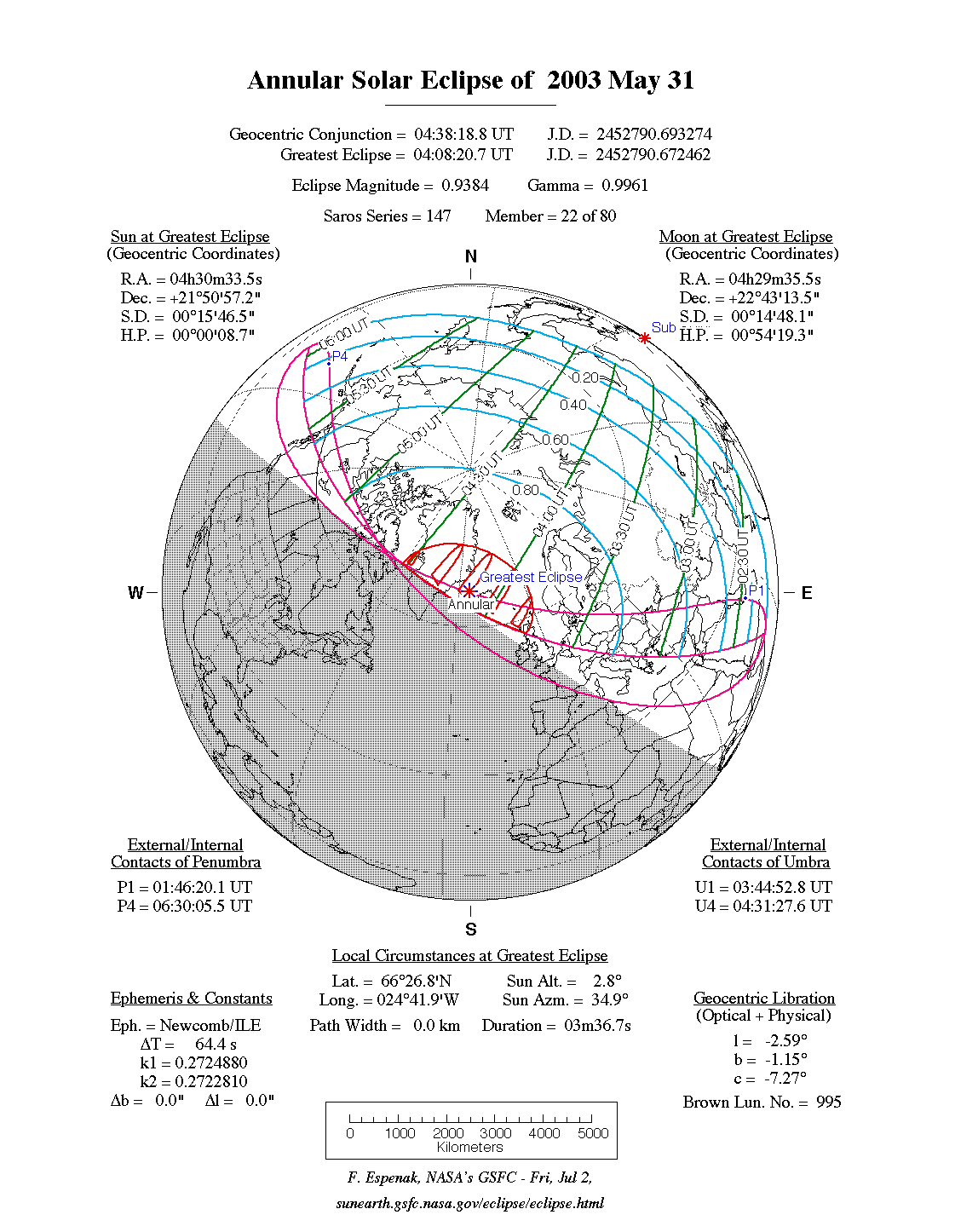
2003 May 31: Annular Solar Eclipse
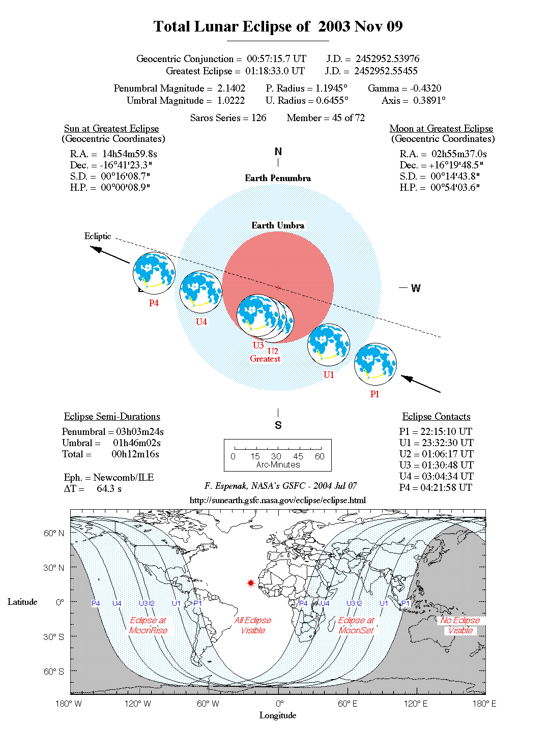
2003 Nov 09: Total Lunar Eclipse
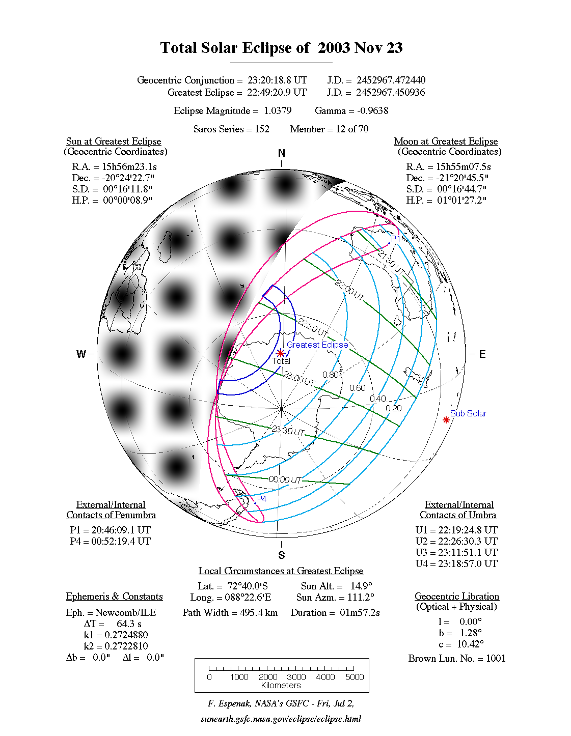
2003 Nov 23: Total Solar Eclipse
A full report Eclipses During 2003 will be published in the Observer's Handbook 2003.
The next total eclipse of the Sun is visible from southern Africa. The path of the Moon's umbral shadow begins in the South Atlantic, off the west coast of equatorial Africa. It crosses through Angola, Zambia, Namibia, Botswana, Zimbabwe, South Africa and Mozambique (Figure 8). Totality takes place in the morning hours with a central duration ranging from 1 to 1.5 minutes. The track continues across the Indian Ocean and ends in southern Australia north of Adelaide.
Complete details will eventually be posted on the NASA TSE2002 web site as well as in the next NASA bulletin scheduled for publication in late 2000. The TSE2002 web site address is:
Special bulletins containing detailed predictions and meteorological data for future solar eclipses of interest are prepared by F. Espenak and J. Anderson, and are published through NASA's Publication series. The bulletins are provided as a public service to both the professional and lay communities, including educators and the media. A list of currently available bulletins and an order form can be found at:
Single copies of the eclipse bulletins are available at no cost by sending a 9 by 12 inch self-addressed envelope stamped with postage for 11 ounces (310 grams. Please print the eclipse year on the envelope's lower left corner. Use stamps only, since cash or checks cannot be accepted. Requests from outside the U. S. and Canada may send ten international postal coupons. Mail requests to: Fred Espenak, NASA/Goddard Space Flight Center, Code 693, Greenbelt, Maryland 20771, USA. The NASA eclipse bulletins are also available over the Internet, including out-of-print bulletins. Using a Web browser, they can be read or downloaded via the World-Wide Web from the GSFC/SDAC (Solar Data Analysis Center) eclipse page:
The original Microsoft Word text files and PICT figures (Macintosh format) are also available via anonymous ftp. They are stored as BinHex-encoded, StuffIt-compressed Mac folders with .hqx suffixes. For PC's, the text is available in a zip-compressed format in files with the .zip suffix. There are three sub directories for figures (GIF format), maps (JPEG format), and tables.
A special solar and lunar eclipse web site is available via the Internet at:
The site features predictions and maps for all solar and lunar eclipses well into the 21st century. Special emphasis is placed on eclipses occurring during the next two years with detailed path maps, tables, graphs and meteorological data. Additional catalogs list every solar and lunar eclipse over a 5000 year period.
All eclipse predictions were generated on a Power Macintosh 8500/150 using algorithms developed from the Explanatory Supplement [1974] with additional algorithms from Meeus, Grosjean, and Vanderleen [1966]. The solar and lunar ephemerides were generated from Newcomb and the Improved Lunar Ephemeris. A correction of -0.6" was added to the Moon's ecliptic latitude to account for the difference between the Moon's centre of mass and centre of figure. For partial solar eclipses, the value used for the Moon's radius is k=0.2724880. For lunar eclipses, the diameter of the umbral shadow was enlarged by 2% to compensate for Earth's atmosphere and the effects of oblateness have been included. Text and table composition was done on a Macintosh using Microsoft Word. Additional figure annotation was performed with Claris MacDraw Pro.
All calculations, diagrams, tables and opinions presented in this paper are those of the author and he assumes full responsibility for their accuracy.
Special thanks to National Space Club summer intern Bailey McCreery for his valuable assistance in preparing this web page. (July 2001)
![]()
![]()

Webmaster: Fred Espenak Planteary Systems Laboratory - Code 693 Email: fred.espenak@nasa.gov NASA/Goddard Space Flight Center, Greenbelt, MD 20771, USA |
|---|
Last revised: 2007 Jun 18 - F. Espenak