
|
|---|
|
|
|---|


The following report is extracted from Eclipses During 1999 published in the Observer's Handbook 1999, Royal Astronomical Society of Canada.
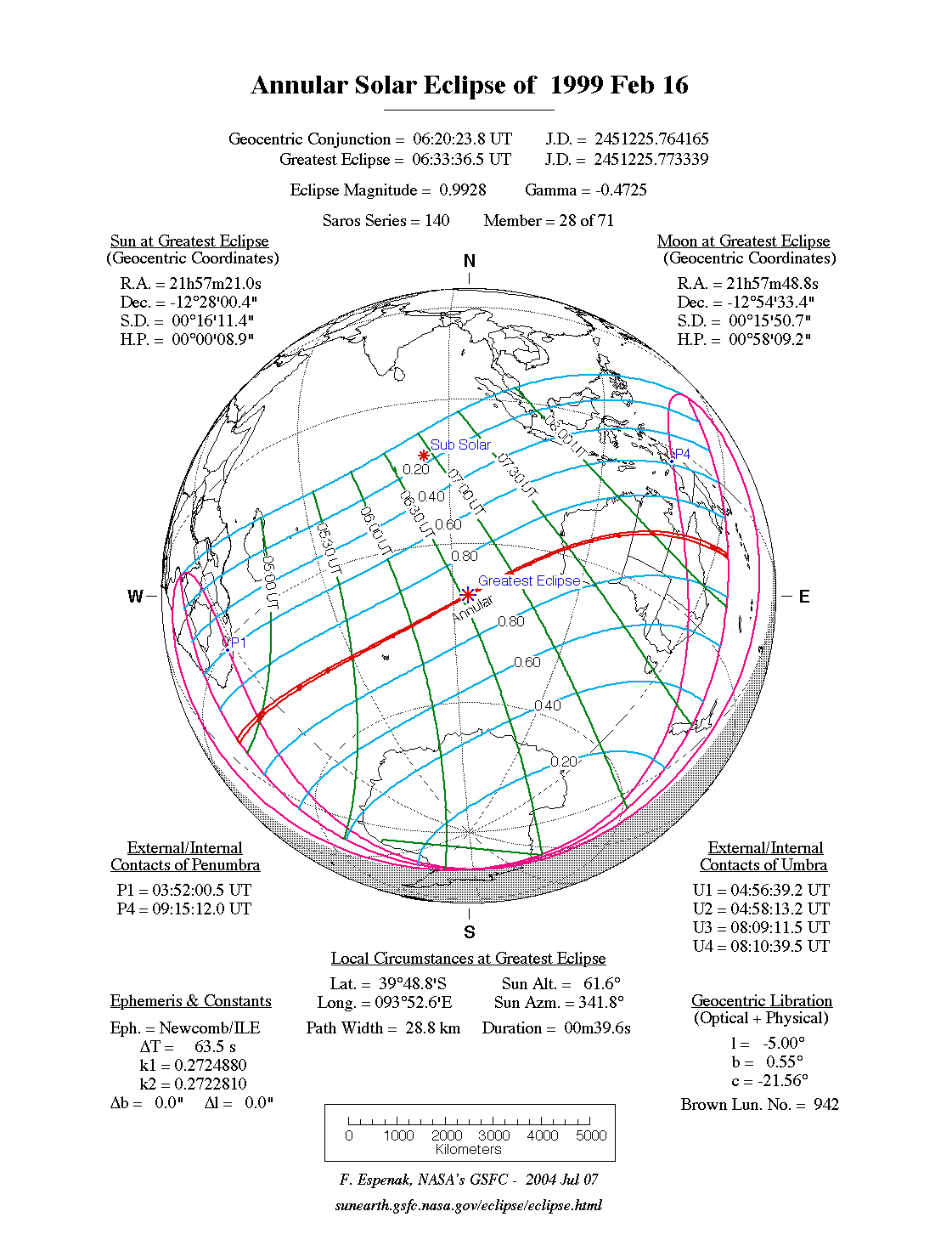
The first solar eclipse of 1999 is annular and is confined to the southern hemisphere Figure 2. Eclipses in this Saros series changed from total to annular during the early 20th century. As a consequence, the path of the antumbra is quite narrow and the duration is short. The central path begins about 1000 kilometres south of South Africa at 04:57 UT. An hour and a half later, the instant of greatest eclipse occurs in the middle of the Indian Ocean (06:34 UT). The path is only 29 kilometres wide and the duration of annularity is a brief 40 seconds.
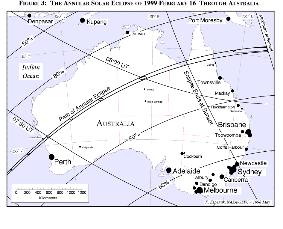
Nearly another hour passes before the antumbra finally reaches land. The path of annularity crosses into southwestern Australia about 300 kilometres north of Perth at 07:28 UT (Figure 3). The Sun's altitude is then 45°, the path width is 42 kilometres and the duration of annularity is 48 seconds. At mid-eclipse, the annular ring of the Sun will have a mean thickness of only 9 arc-seconds! Since the Moon's limb exhibits orthographic features on the order of 3 to 5 arc-seconds, this event should offer a spectacular display of Baily's Beads.
Continuing on its northeastern course, the path crosses arid parts of Western Australia through relatively remote and unpopulated areas. Entering the Northern Territory, the antumbra passes 400 kilometres north of Alice Springs at 08:00 UT. The Sun's altitude will then be 39° as the path width (48 kilometres) and central duration (51 seconds) gradually increase. This occurs because the curvature of Earth brings these regions further from the Moon and deeper into the antumbral shadow.
The path stretches through northern Queensland passing 100 kilometers
north of Cairns where a partial eclipse of magnitude 0.97 will be seen with the Sun 10° above the horizon at 08:07 UT. The path ends three minutes later in the Coral Sea.
The length of the entire path of annularity is approximately 13,700 kilometres which encompasses about 0.20% of Earth's total surface area. Path coordinates and centre line circumstances are presented in Table 1. Local circumstances for cities throughout the path are given in Table 2. All times are given in Universal Time. The Sun's altitude and azimuth, the eclipse magnitude and obscuration are all given at the instant of maximum eclipse.
Although this eclipse is nearly total, observers are cautioned that solar filters are still required even during the exquisitely narrow annular phase. Direct naked eye viewing could lead to eye damage or even blindness. At several recent annular eclipses, observers have demonstrated that it is possible to photograph prominences and the innermost corona. These features are visible along the Moon's dark limb opposite the brilliant crescent immediately before and after the annular phase. Great care should be taken to block or occult the bright solar crescent. Refractors of good quality are favored here since any internal reflections will lower the contrast or even obscure the prominences or corona. Since the Moon obscures over 98% of the Sun, this eclipse is especially favored for making such observations during annularity.
The annular solar eclipse of 1984 May 30 had a magnitude of 0.9979 from Greensboro, NC.
(If you have problems printing the limb profiles on one sheet of paper, try setting your printer scale to 50%)
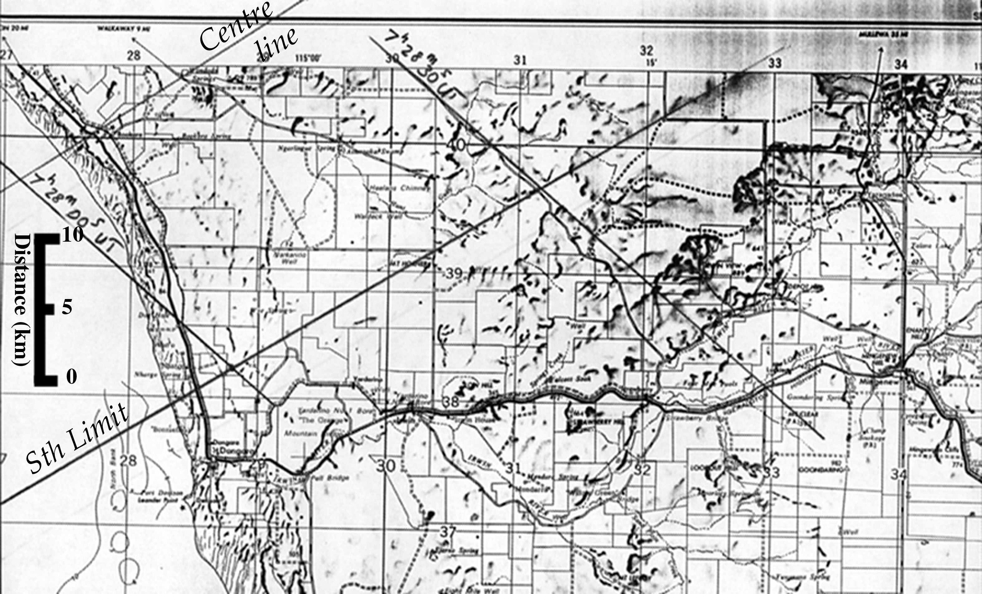
Joseph Cali of Australian National University has kindly plotted the eclipse path on detailed maps of the Geraldton/Doongara area:
Mr. Cali writes:
"The roads are the darker lines usually not very straight. Some of these are sealed near Geraldton but even the major road to Yalgoo was unsealed last time I was out there about 5 years ago. It is nonetheless very trafficable in dry weather. Dotted lines indicate an unsealed rough 4wd tracks and the rectangular areas marked on the maps in thin solid lines are fences not roads. Observers without GPS assistance can count fence lines and compare the angles that fence lines make with the road to navigate themselves to the centreline or limits. There may be a small plotting error error in the marked path positions(+/- 0.2 km) and event times(+/- 1 second). This should be adequate for most observers."
"The two maps cover about one hours drive out of Geraldton along the path."
Eclipse chaser Olivier Staiger has passed along the following links for LIVE eclipse webcasts/webreports on February 16.
All eclipse calculations are by Fred Espenak, and he assumes full responsibility for their accuracy.
Planetary Systems Branch - Code 693
![]()
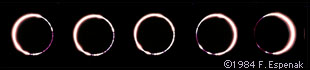
Various stages of the annular solar eclipse 1984 May 30.
Courtesy of MrEclipse.com.
In comparison, the 1999 Feb 16 annular eclipse will have a magnitude of 0.9905 as seen south of Geraldton, Australia.
![]()
Coordinates of Antumbral Eclipse Path
![]()
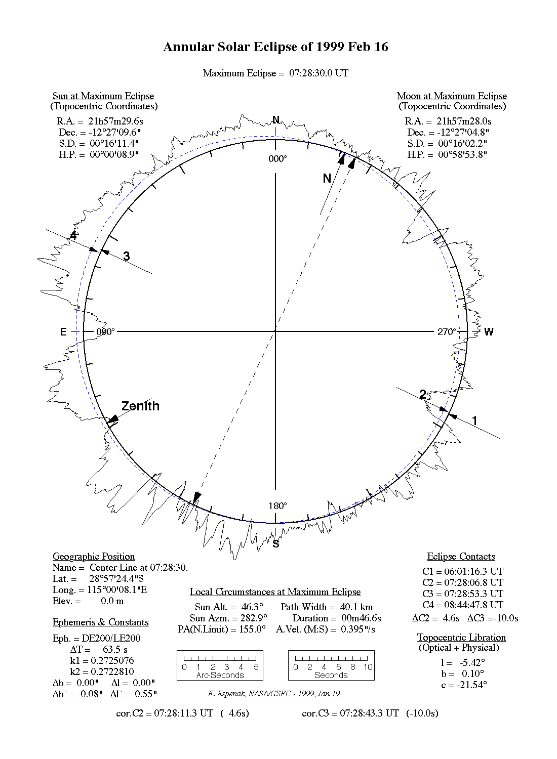
Lunar Limb Profile
![]()
Detailed Maps for Geraldton Area
![]()
Weather
![]()
Live Webcasts of the 1999 Annular Eclipse
(This will be a small partial eclipse from the Indian Ocean)
![]()
Other Links for the 1999 Annular Eclipse
![]()
Reports & Photos of the 1999 Annular Eclipse
![]()
Permission is freely granted to reproduce this data when accompanied by an acknowledgment.
![]()
Return to Eclipse Home Page
![]()

Eclipse Predictions & WebMaster: Fred Espenak
e-mail: espenak@gsfc.nasa.gov
NASA/Goddard Space Flight Center, Greenbelt, Maryland 20771 USA