
|
|---|
|
|
|---|
The eclipse track crosses into Zambia at Chavuma Falls, passing north of the city of Zambezi. From here it heads east southeastward across Kafue National Park to pass 40 km north of the capital of Lusaka, the only major city to lie within totality. East of Lusaka, the umbral path reaches the Zambezi River again, passing just to the north of Lake Kariba to cross into Zimbabwe.
Access to the center line is relatively easy in Zambia. The highway from Lusaka west to Mongu (M9) stays within the umbral shadow for over 300 km, though well to the south of the centerline. This route is described as being in "protracted repair" by one guide book, but is the main route to Kafue National Park and the western half of the country. Two other highways head north from Lusaka to cross the centerline in two places. Landless Corner, 69 km north of the capital, lies just beyond the middle of the shadow path on the Great North Road. To the northeast, the Great East Road to Chipata, one of the best in the country, crosses the centerline at about 60 km distance.
Zambia has a number of safari settings for the eclipse, particularly at Kafue National Park in the northwestern part of the country. This park is one of the largest in Africa, swampy in the wet season but offering some of the best weather along the track in June. The Kafue Park gate is easy to reach from Lusake, 279 km to the east, but the centerline lies a further hundred km to the north of the gate and must be traveled on softer roads within the park. Even though it is the dry season, 4-wheel drive vehicles may be necessary to reach the shadow axis by this route.
There are over 70 different tribes in Zambia, but one has a special association with eclipses. Originally from South Africa, the Ngoni migrated into eastern Zambia (and into Zimbabwe) around 1830 to escape the Great Shaka Zulu. A solar eclipse and a great celebration marked the day they crossed the Zambezi to their new homeland. This eclipse and the one in 2002 which also touches Zambia and Zimbabwe will likely provide opportunity for further celebration.
Winter months in Zambia are virtually rainless. The circulation associated with the anticyclones to the south dries the mid levels of the atmosphere and suppresses any tendency to form rain-bearing clouds. The southeast trade winds, blowing first across Madagascar and then Mozambique, carry little moisture into the mid-continent in June, blocked in large part by the Eastern Highlands.
The most important source of cloudiness in Zambia in June comes in association with the passage of a succession of highs and lows across South Africa at intervals of a few days. Passage of a high pressure cell results in a flow of cold air from the south that is restricted in its inland motion by the Drakensberg Mountains in South Africa and the Eastern Highlands in Zimbabwe. The cold air finds an opening into the continent along the Limpopo River, and less commonly, along the Zambezi. This air has a high relative humidity and as it rises along the slopes of the Eastern Highlands and the Zambezi Escarpment, pushed by easterly winds, it quickly turns into an extensive broken stratiform cloudiness. Much of the impact of this cloudiness is felt over the lowlands of Mozambique and eastern Zimbabwe, but the continuing push of the winds frequently forces the cloud deep into the Limpopo and Zambezi valleys.
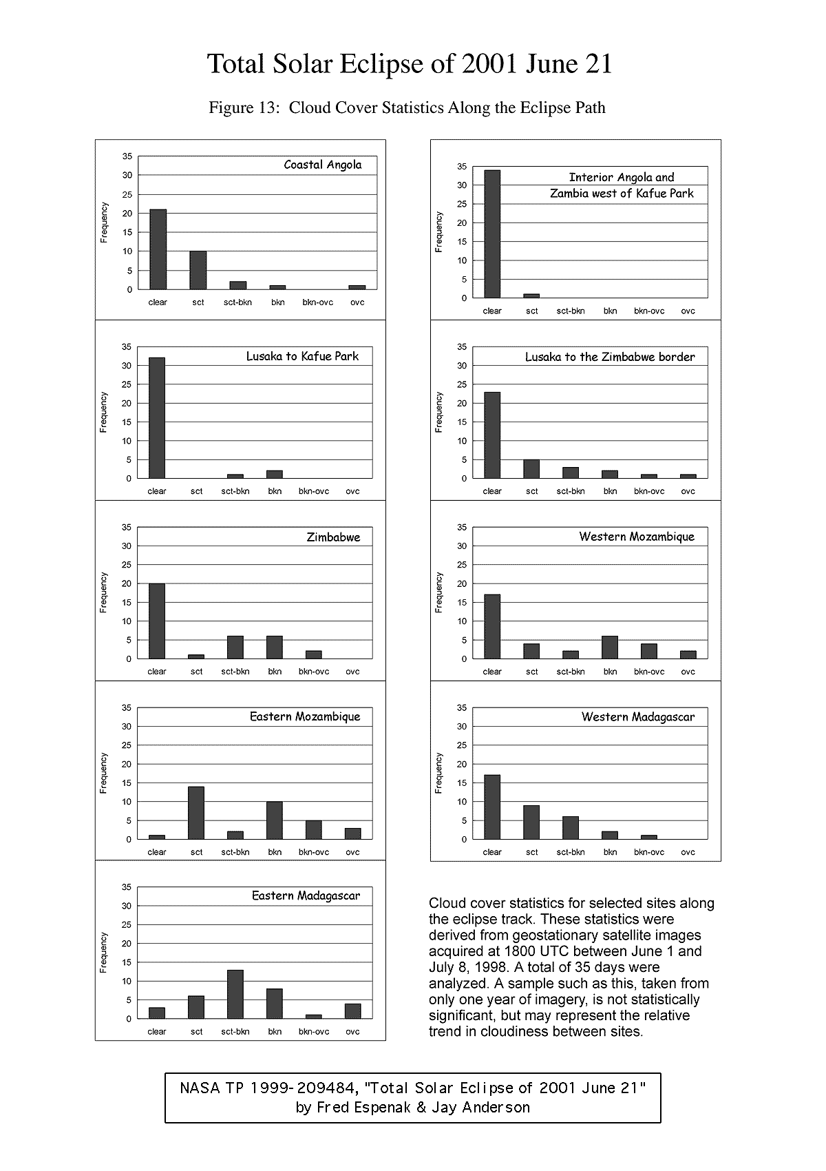
This pattern of cloudiness is known locally as a guti; its counterpart in Malawi is the chiperoni. The cool southerly winds, cloudiness, and drizzle can bring an abrupt change to the normally sunny and dry weather. These invasions of cold air occur year round, at about weekly intervals, but in Zambia, well inland from the Mozambique Channel, the incidence of cloudiness is much reduced (Figure 13) and the cloud cover tends to be more scattered than at lower elevations in the Zambezi Valley. It is uncommon for the guti to have an influence beyond a line from Lusaka to Mpika, along the Great North Road. In the graphs of Figure 13 the effect can be seen by comparing the cloudiness in "Lusaka to Kafue Park" with "Lusaka to the Zimbabwe Border". The effect of the guti can also be seen in the sunshine statistics in Table 17.
Moisture that travels inland from the south, following the Limpopo River, is unlikely to make it as far north as the eclipse track. The sunshine statistics for Livingstone, Victoria Falls and Bulawayo speak to the efficiency of the blocking caused by the Eastern Highlands.
A guti usually doesn't persist for more than a day in the vicinity of Lusaka, breaking up quickly as it moves onto the plateau. A high sun and generally drier surrounding conditions soon change the stratiform cloud into cumuliform types that mix with the air of the plateau and dissipate. Satellite images from 1998 show that patchy cloudiness associated with a guti, cloud that might affect observations of the eclipse, was observed in the Lusaka-Zambezi area on seven occasions in the 35 days of observation (Figure 13). Twenty-eight days were clear or had only scattered cloud and would not have interfered with a view of the Sun.
Of the seven critical days, three had scattered to broken cloud that would likely disappear between first and second contact, though some movement might be necessary to avoid the larger patches. The remaining four days would have required more definite movement, perhaps a hundred kilometers to the west, though on two of these occasions a patch of cloud drifted west almost to Kafue National Park.
On days that will tend to be cloudy, the morning often greets the sunrise with a heavy cloud cover, sometimes overcast. As the sun rises, the cloud will dissipate, being relatively thin and at a high level so that it mixes readily with drier atmospheric layers. The improvement doesn't last however, as a little more heating brings the onset of cumulus cloudiness, encouraged by the invisible but still-present moisture which formerly fed the dawn cloudiness. Thus we have a very characteristic pattern of morning cloud, promising mid-morning clearing, and then a return to noontime cloudiness again.
If the morning cloud burns off quickly and the resulting noontime cumulus clouds are widely dispersed, then the cooling associated with the arrival of the shadow is most likely to dissipate the small amount of cloud and bring a successful eclipse. If the noon clouds are heavy and return the sky to an near-overcast condition, then the eclipse is in danger. Such skies are likely to be reluctant to clear as the shadow approaches, and instead settle into a stratiform layer that will obscure much of the spectacle. Even in this case the whole event may not be lost, as central African cloud layers are typically very thin in this season and the inner parts of the corona and the prominences may be quite visible. Nevertheless, a heavy cumulus cloudiness at noon is a sign that alternative plans should be readied for use.
Viewing locations along the Great East Road, which runs parallel to and about 50 km west of the Zambezi, are most at risk. Selecting a backup site along the Great North Road (though Zambezi cloudiness can reach this area as well) would be a good idea for those planning to choose locations east of Lusaka. Fortunately, the approach of cloud along the Zambezi River can often be seen a day or two ahead from satellite imagery.
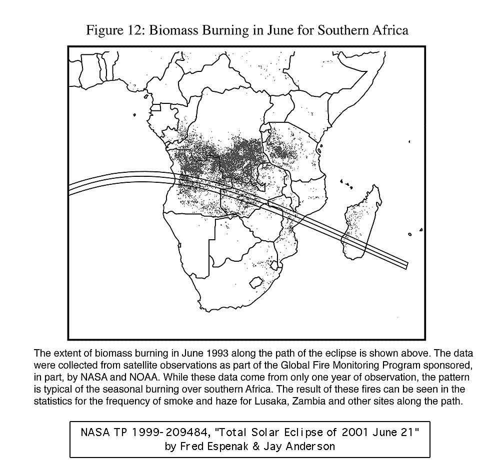
As in Angola, one element that will likely affect the view of the eclipse is the extensive haziness that overlies the interior plateau in the winter months (Table 17, Figure 12). This haziness is man-made, the consequence of an extensive burning of the veldt that begins in earnest in June and reaches its worst in September or October. Much of the burning occurs in the grasslands north of the eclipse track and occasionally visibilities may be reduced below 5 km. The haze is thickest in the morning hours and disperses through the lower atmosphere during the day. While unlikely to have a major impact on the view of the eclipse, it could reduce the visibility of the fainter parts of the outer corona.
Temperatures on the Zambia-Zimbabwe plateau are pleasant but cool in June, with daytime highs generally in the low to mid twenties and morning lows between 5 and 10 degrees. The dry air and generally cloudless skies should bring a significant drop in ground temperatures during the eclipse especially on the plateau west of Lusaka. Occasional winter cold outbreaks come overland from Botswana and arrive in Zambia and Zimbabwe with dew points well below zero. This dry air brings no cloudiness with it, but nighttime temperatures can fall below the freezing mark in southern parts and below the 5° mark near the eclipse track.
Adapted from NASA TP 1999-209484 "Total Solar Eclipse of 2001 June 21". Permission is freely granted to reproduce this information and data when accompanied by an acknowledgment of the source:
"From Total Solar Eclipse of 2001 June 21 by Fred Espenak and Jay Anderson, NASA"

WebMaster: Fred Espenak Planetary Systems Branch - Code 693 e-mail: espenak@lepvax.gsfc.nasa.gov NASA/Goddard Space Flight Center, Greenbelt, Maryland 20771 USA
|
|---|