Annular Solar Eclipse of 2012 May 20
On 2012 May 20/21, an annular eclipse of the Sun is visible from within a narrow corridor that traverses Earth's northern Hemisphere. The path of the Moon's antumbral shadow begins in eastern Asia and crosses the North Pacific Ocean where it ends in the western United States. The Moon's penumbral shadow produces a partial eclipse visible from a much larger region covering East Asia, North Pacific, North America and Greenland.
For those traveling to the USA for the eclipse, please note that the eclipse occurs in the late afternoon of May 20 local time.
Although it was not possible to publish a NASA Eclipse Bullet for the 2012 annular eclipse, this special web page contains much of the material that would have appeared in it.
Description of the 2012 Annular Solar Eclipse
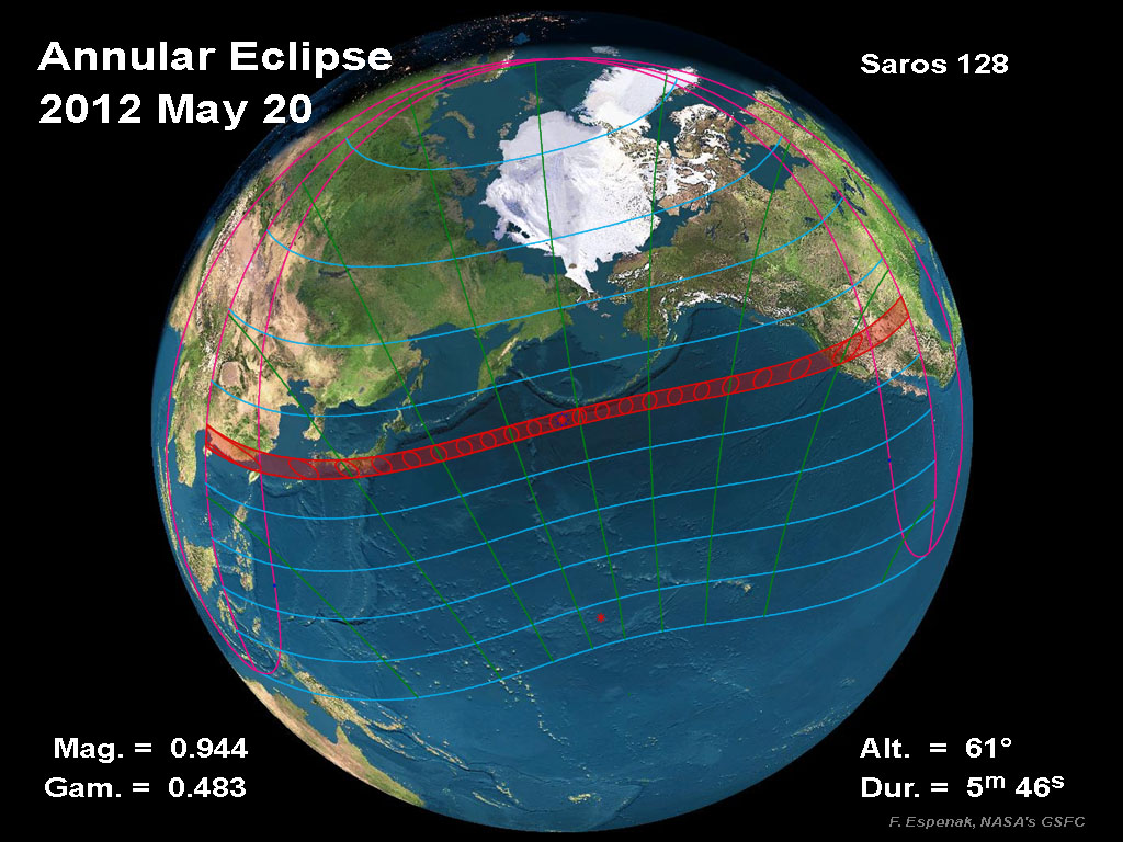
The 2012 May 20 eclipse occurs at the Moon's descending node in central Taurus. An annular eclipse will be visible from a 240 to 300 kilometre-wide track that traverses eastern Asia, the northern Pacific Ocean and the western United States. A partial eclipse is seen within the much broader path of the Moon's penumbral shadow, that includes much of Asia, the Pacific and the western 2/3 of North America (Figure 1).
The annular path begins in southern China at 22:06 UT. Because the Moon passed through apogee one day earlier (May 19 at 16:14 UT), its large distance from Earth produces a wide path of annularity. Traveling eastward, the shadow quickly sweeps along the southern coast of Japan as the central line duration of annularity grows from 4.4 to 5.0 minutes.
Tokyo lies 10 kilometres north of the central line. For the over 10 million residents within the metropolitan area, the annular phase will last 5 minutes beginning at 22:32 UT (on May 21 local time). The annular ring is quite thick because the Moon's apparent diameter is only 94% that of the Sun. Traveling with a velocity of 1.1 kilometres/second, the antumbral shadow leaves Japan and heads northeast across the Northern Pacific. The instant of greatest eclipse [1] occurs at 23:52:47 UT when the eclipse magnitude [2] reaches 0.9439. At that instant, the duration of annularity is 5 minutes 46 seconds, the path width is 237 kilometres and the Sun is 61° above the flat horizon formed by the open ocean.
The shadow passes just south of Alaska's Aleutian Islands as the central track slowly curves to the southeast. After a 7000 kilometre-long ocean voyage lasting nearly 2 hours, the antumbra finally reaches land again along the rugged coastlines of southern Oregon and northern California (Figure 2) at 01:23 UT (May 20 local time).
Redding, CA lies 30 kilometres south of the central line. Nevertheless, it still experiences an annular phase lasting 4 1/2 minutes beginning at 01:26 UT. It is already late afternoon along this section of the eclipse path. The Sun's altitude is 20° during the annular phase and decreasing as the track heads southeast. Central Nevada, southern Utah, and northern Arizona are all within the annular path.
By the time the antumbra reaches Albuquerque, NM (01:34 UT), the central duration is still 4 1/2 minutes, but the Sun's altitude has dropped to 5°. As its leading edge reaches the Texas Panhandle, the shadow is now an elongated ellipse extending all the way to Nevada. Seconds later, the antumbra begins its rise back into space above western Texas as the track and the annular eclipse end.
During the course of its 3.5-hour trajectory, the antumbra's track is approximately 13,600 kilometres long and covers 0.74% of Earth's surface area. Path coordinates and central line circumstances are presented in Table 1.
Partial phases of the eclipse are visible primarily from the USA, Canada, the Pacific and East Asia. Local circumstances for a number of cities are found in Table 2 (Canada, Mexico and Asia) and Table 3 (USA). All times are given in Universal Time. The Sun's altitude and azimuth, the eclipse magnitude and obscuration are all given at the instant of maximum eclipse.
The NASA JavaScript Solar Eclipse Explorer is an interactive web page that can quickly calculate the local circumstances of the eclipse from any geographic location not included in Table 1:
eclipse.gsfc.nasa.gov/JSEX/JSEX-index.html
This is the 33rd eclipse of Saros 128 (Espenak and Meeus, 2006). The family began with a series of 24 partial eclipses starting on 0984 Aug 29. The first central eclipse was total and took place on 1417 May 16. After three more totals and four hybrid eclipses, the series changed to annular on 1561 Aug 11. Subsequent members of Saros 128 were all annular eclipses with increasing durations, the maximum of which was reached on 1832 Feb 01 and lasted 08 minutes 35 seconds. The duration of annularity of each succeeding eclipse is now dropping and will reach 4 minutes with the last annular eclipse of the series on 2120 Jul 25. Saros 128 terminates on 2282 Nov 01 after a string of 9 partial eclipses. Complete details for the 73 eclipses in the series (in the sequence of 24 partial, 4 total, 4 hybrid, 32 annular, and 9 partial) may be found at:
eclipse.gsfc.nasa.gov/SEsaros/SEsaros128.html
The above information is based on the article published in the RASC Observer's Handbook for 2012.
Footnotes
[1] The instant of greatest eclipse for solar eclipses occurs when the distance between the Moon's shadow axis and Earth's geocentre reaches a minimum.
[2] Eclipse magnitude for solar eclipses is defined as the fraction of the Sun's diameter occulted by the Moon.
[3] Eclipse obscuration is defined as the fraction of the Sun's area occulted by the Moon.
[4] The Saros is a period of 6,585.3 days (18 years 11 days 8 hours) in which eclipses (both solar and lunar) repeat. The geometry isn't exact but close enough for a Saros series to last 12 or more centuries.
Orthographic Map of the Annular Solar Eclipse
The following map shows the overall regions of visibility of the partial eclipse as well as the path of the Annular eclipse through Asia, the Pacific and North America. It uses high resolution coastline data from the World Data Base II (WDB).
Interactive Map of the Path of Annularity
An implementation of Google Map has been created which includes the central path of the 2012 total solar eclipse. This allows the user to select any portion of the path and to zoom in using either map data or Earth satellite data.
Detailed Maps of the Path of Annularity
Although a NASA eclipse bulletin was not published for this eclipse, Jay Anderson still generated a series of detailed eclipse maps.
- Global Map
- China and Hong Kong
- China & Taiwan
- Japan (South)
- Japan (central)
- Japan (North)
- Western USA
- California
- Nevada
- Utah & Arizona
- New Mexico
- New Mexico & Texas
Michael Zeiler and Bill Kramer have also produced an excellent set of maps for the annular eclipse using the NASA Besselian elements.
Eclipse Elements, Shadow Contacts and Path of Annularity
The following tables give detailed predictions including the Besselian Elements, shadow contacts with Earth, path of the antumbral shadow and topocentric data (with path corrections) along the path.
- Table 1 - Elements of the Eclipse
- Table 2 - Shadow Contacts and Circumstances
- Table 3A - Path of the Antumbral Shadow
- Table 3B - Path of the Antumbral Shadow (Extended Version)
- Table 4A - Physical Ephemeris of the Antumbral Shadow
- Table 4B - Physical Ephemeris of the Antumbral Shadow (Extended Version)
- Table 5 - Local Circumstances on the Central Line
- Table 6 - Topocentric Data and Path Corrections Due to Lunar Limb Profile
Coordinate Tables for the Path of Annularity
The following tables provide detailed coordinates for the path of the antumbral shadow as well as the zones of grazing eclipse. They are listed in a format convenient for plotting on maps.
- Table 7A - Mapping Coordinates for the Antumbral Path
- Table 7B - Mapping Coordinates for the Antumbral Path (North America; Extended - 15´ step size)
- Table 8A - Mapping Coordinates for the Zones of Grazing Eclipse
- Table 8B - Mapping Coordinates for the Zones of Grazing Eclipse (North America; Extended - 15´ step size)
Local Circumstances
The following table gives the local circumstances of the eclipse from various cities throughout the Western Hemisphere. All contact times are given in the tables are in Universal Time.
Explanation of Eclipse Maps and Tables
The following links give detailed descriptions and explanations of the eclipse maps and tables.
- Map 1 - Orthographic Map of the Eclipse Path
- Table 1 - Elements of the Eclipse
- Table 2 - Shadow Contacts and Circumstances
- Table 3 - Path of the Umbral (or Antumbral) Shadow
- Table 4 - Physical Ephemeris of the Umbral (or Antumbral) Shadow
- Table 5 - Local Circumstances on the Central Line
- Table 6 - Topocentric Data and Path Corrections Due to Lunar Limb Profile
- Table 7A & 7B - Mapping Coordinates for the Central Path
- Table 8A & 8B - Coordinates for the Zones of Grazing Eclipse
- Mean Lunar Radius
- Lunar Limb Profile
- Limb Corrections to the Path Limits: Graze Zones
Weather
Eclipse Photography
Reproduction of Eclipse Data
All eclipse calculations are by Fred Espenak, and he assumes full responsibility for their accuracy. Permission is freely granted to reproduce this data when accompanied by an acknowledgment:
"Eclipse Predictions by Fred Espenak, NASA's GSFC"
For more information, see: NASA Copyright Information
More information on this eclipse can be found in the Observer's Handbook for 2012.
