
|
|---|
|
|
|---|
![]()
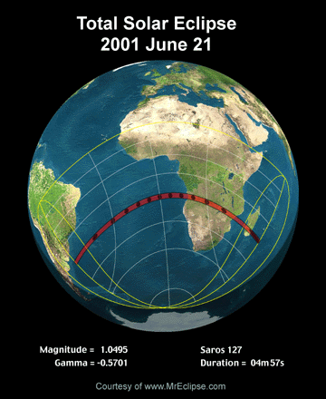
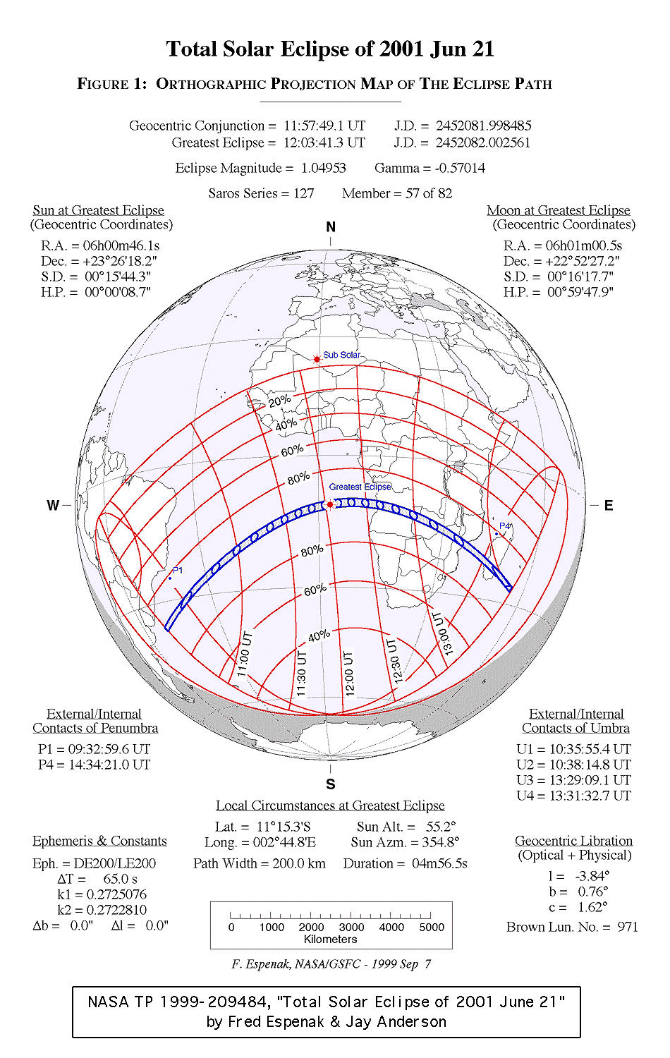
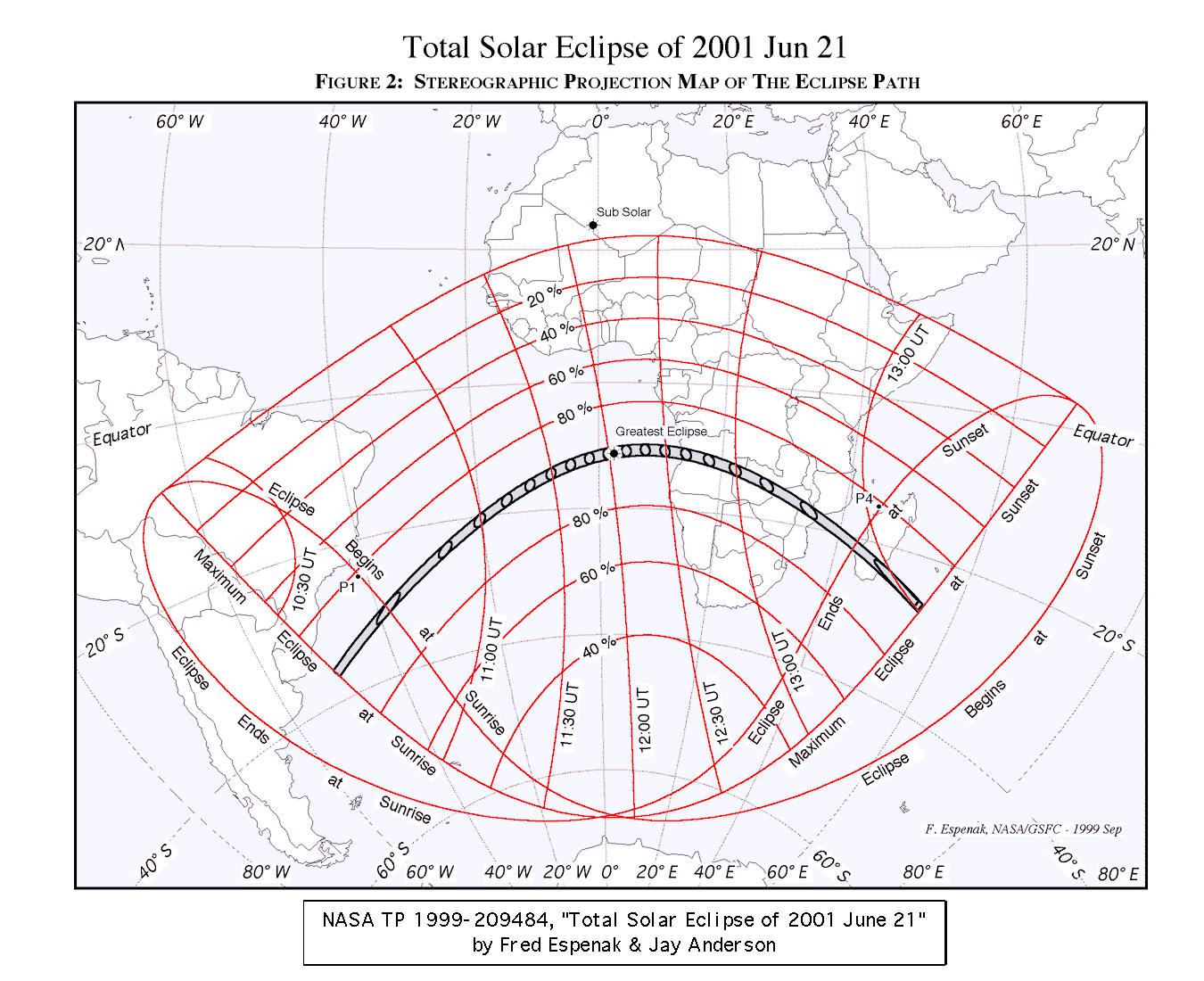
On Thursday, 2001 June 21, a total eclipse of the Sun will be visible from within a narrow corridor which traverses the Southern Hemisphere. The path of the Moon's umbral shadow begins in the South Atlantic and crosses southern Africa, and Madagascar and ends at sunset in the Indian Ocean. A partial eclipse will be seen within the much broader path of the Moon's penumbral shadow, which includes eastern South America and most of Africa (excluding north Africa).
This web site has been established for the purpose of providing detailed predictions, maps, figures and information about this historic event.
The material here is adapted from NASA TP 1999-209484 "Total Solar Eclipse of 2001 June 21" . This publication will be available for distribution in mid December 1999. Instructions and a form for ordering a hard copy of this publication can be found at:
Order Form for NASA 2001 Eclipse Bulletin
Additional and supplemental material for the 2001 eclipse will be published here in the coming months.
In June 2001, these links will provide live web coverage of the eclipse.
The following tables give detailed predictions including the Besselian Elements, shadow contacts with Earth, path of the umbral shadow and topocentric data (with path corrections) along the path. Also included are special extended version tables of path coordinates and graze zones in formats convenient for plotting on maps.
Note: You may need to set your printer to 50% reduction in order to print each figure on a single page.
Text and figures are adapted from NASA TP 1999-209484 "Total Solar Eclipse of 2001 June 21" .
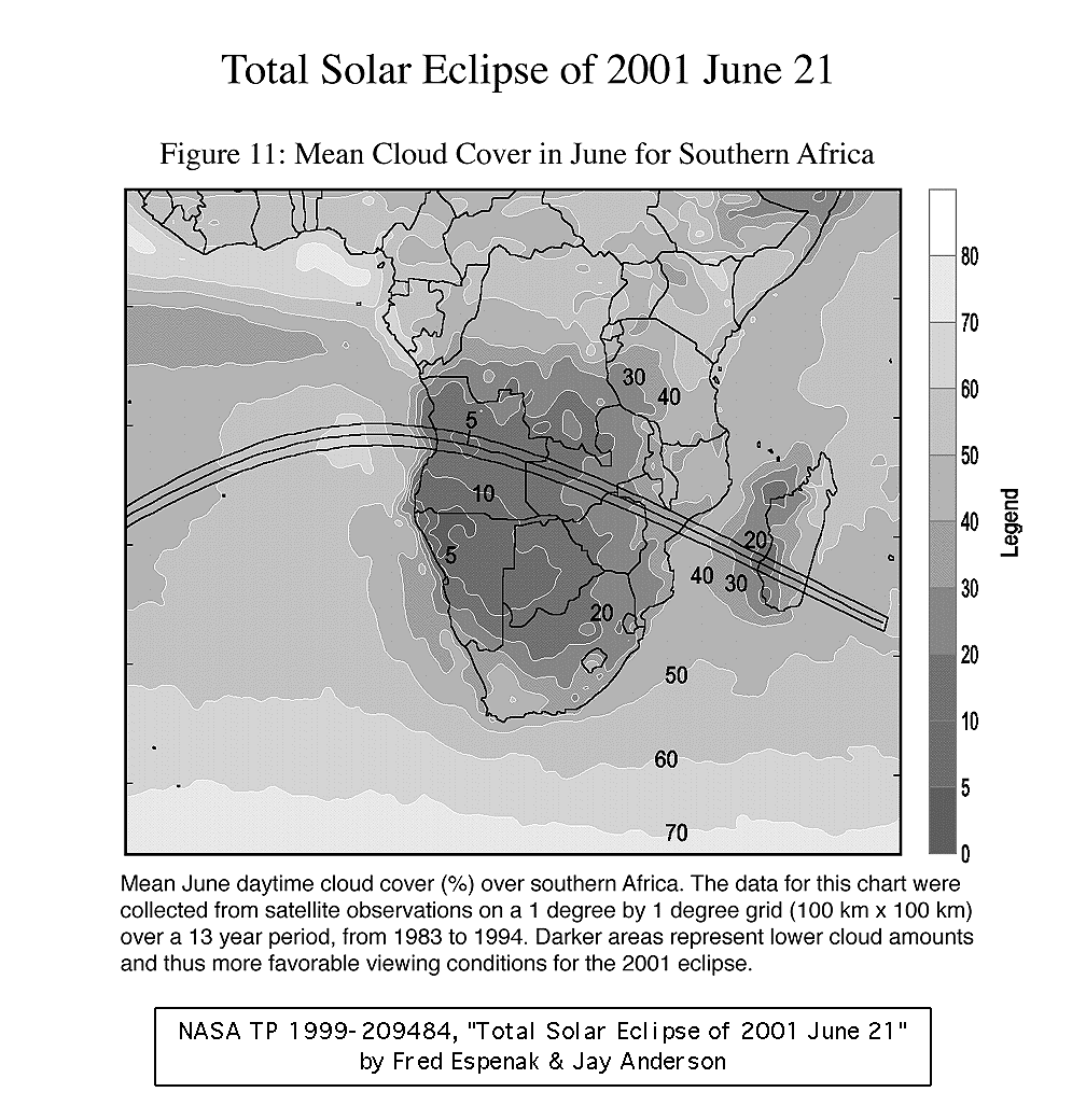
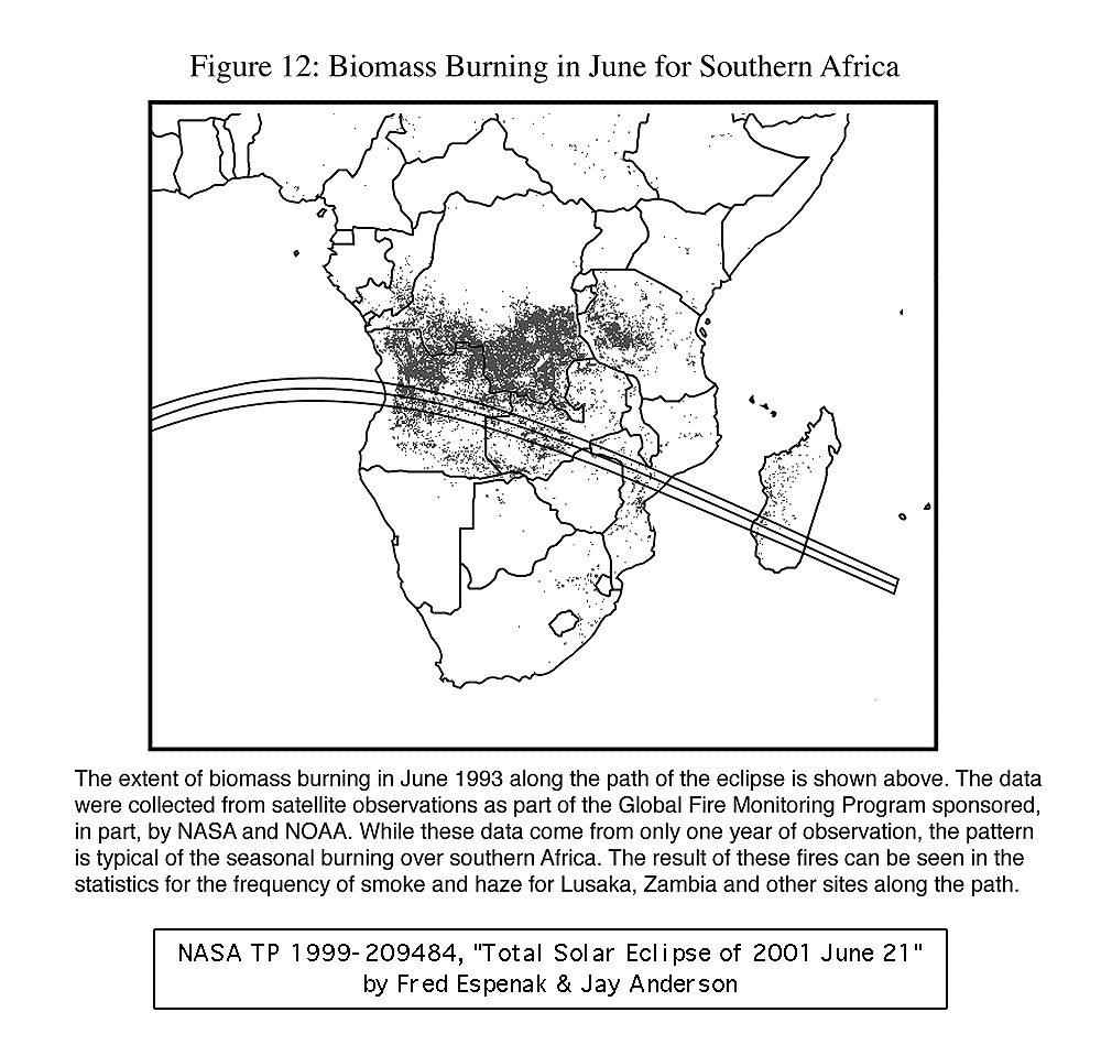
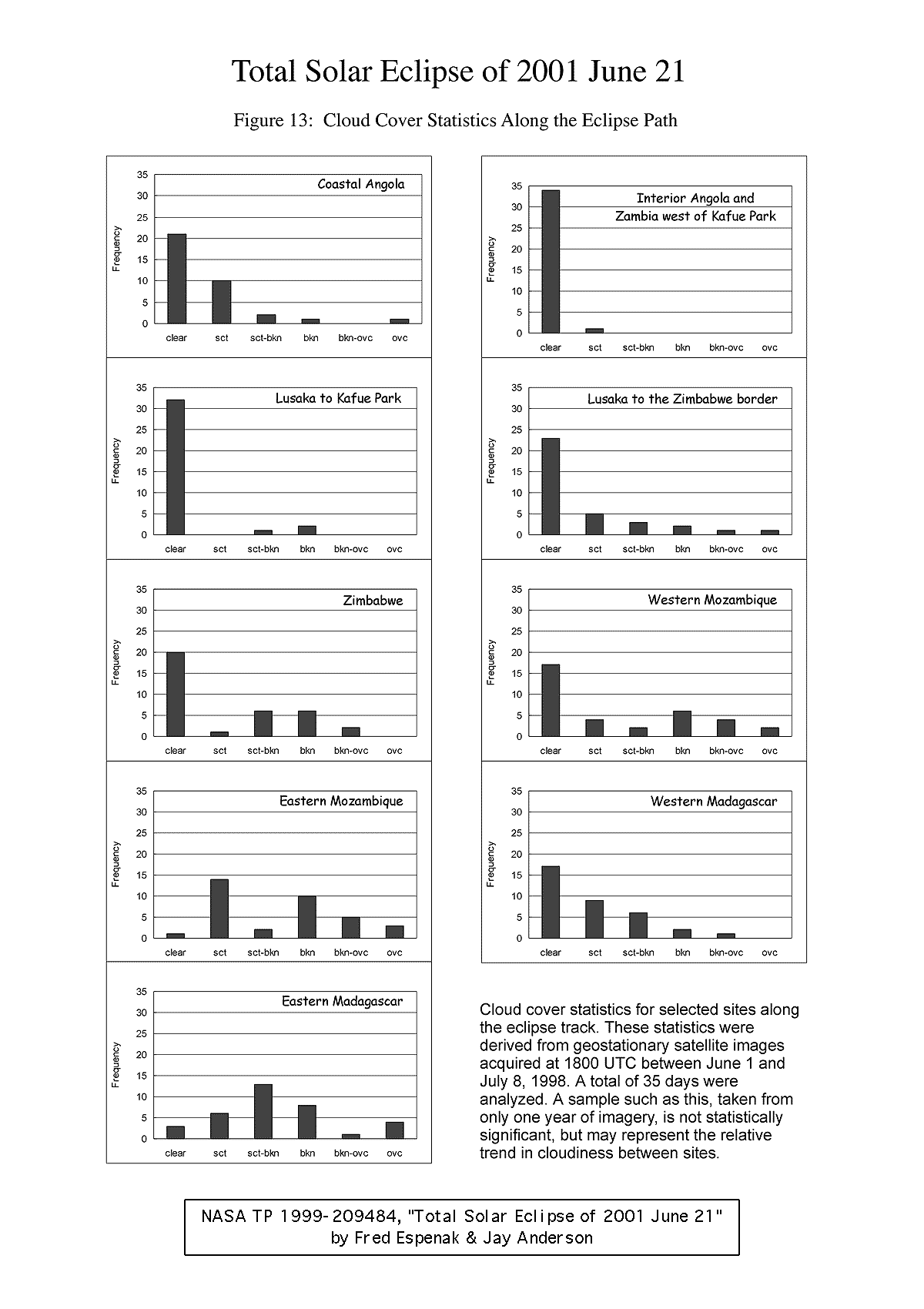
The following maps show the overall regions of visibility of the partial eclipse as well as the path of the total eclipse through Africa.
Note: You may need to set your printer to 50% reduction in order to print each map on a single page.
These maps are adapted from NASA TP 1999-209484 "Total Solar Eclipse of 2001 June 21" .
Watch an exciting Computer Animation the 2001 Eclipse Path!
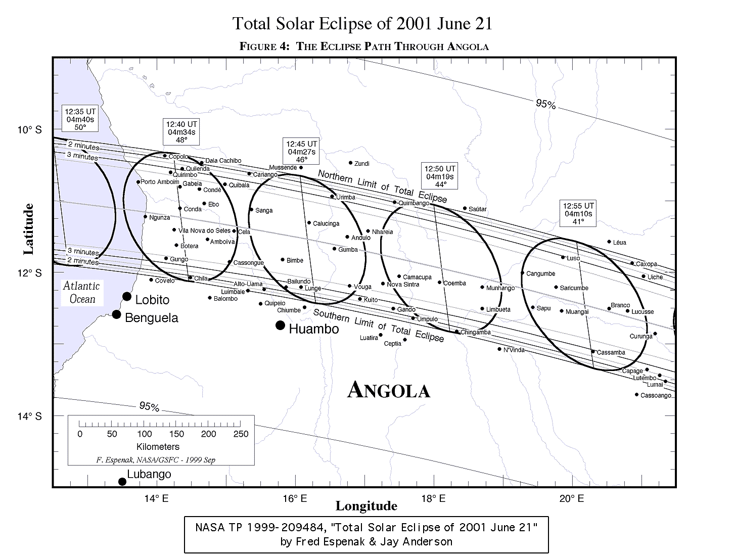
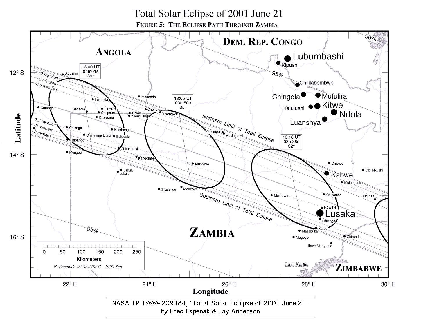
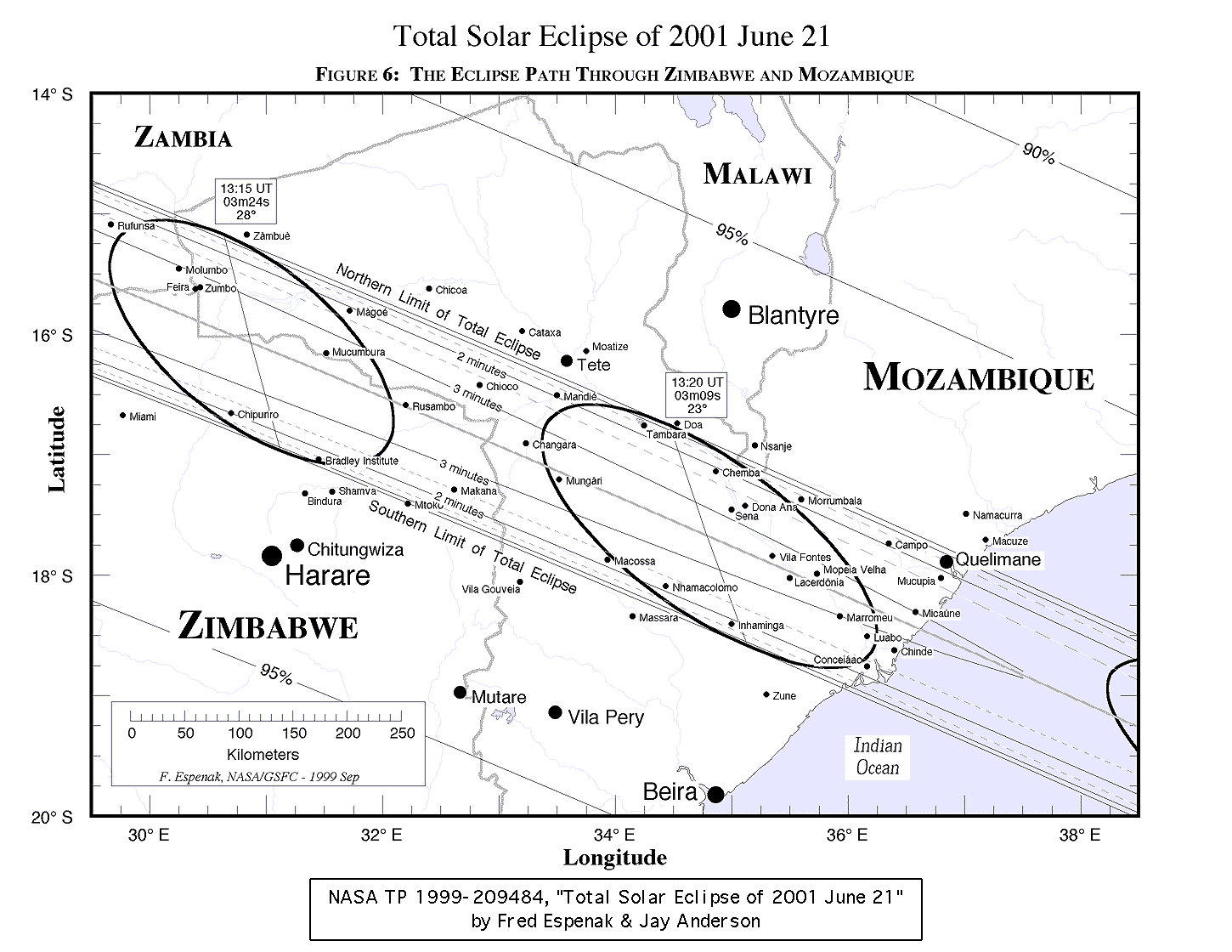
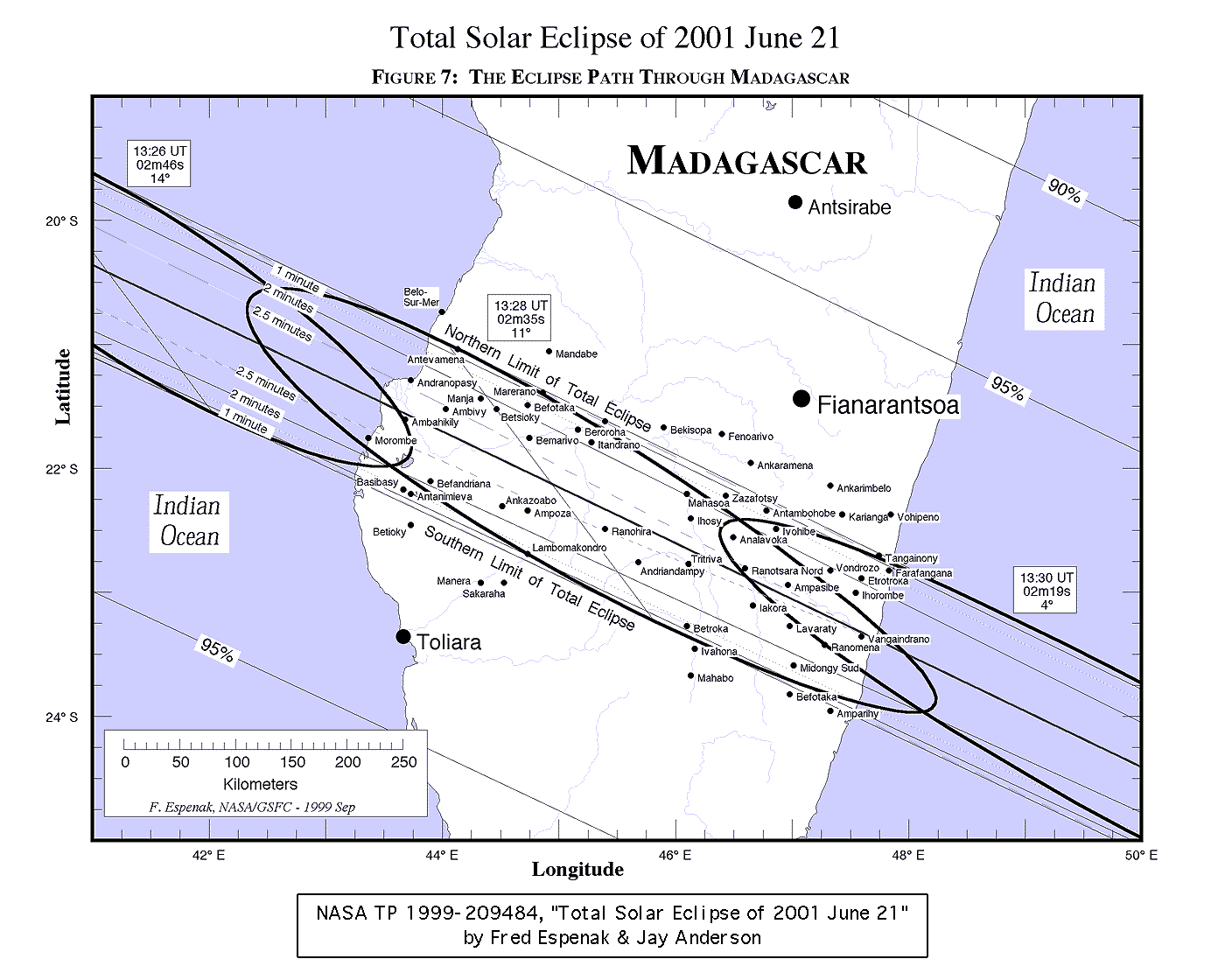
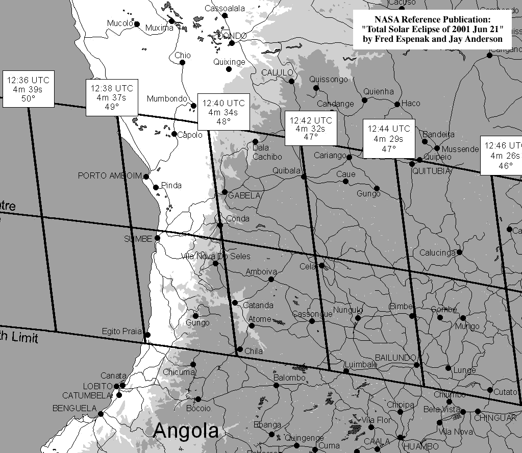
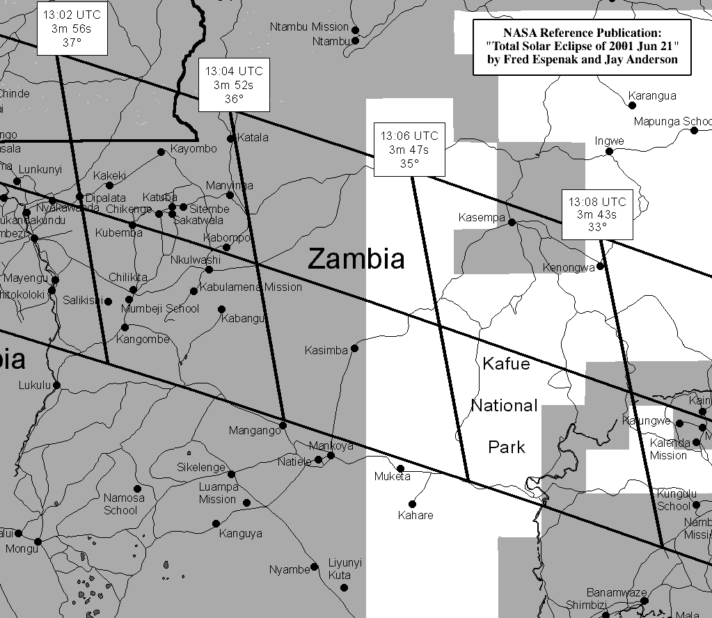
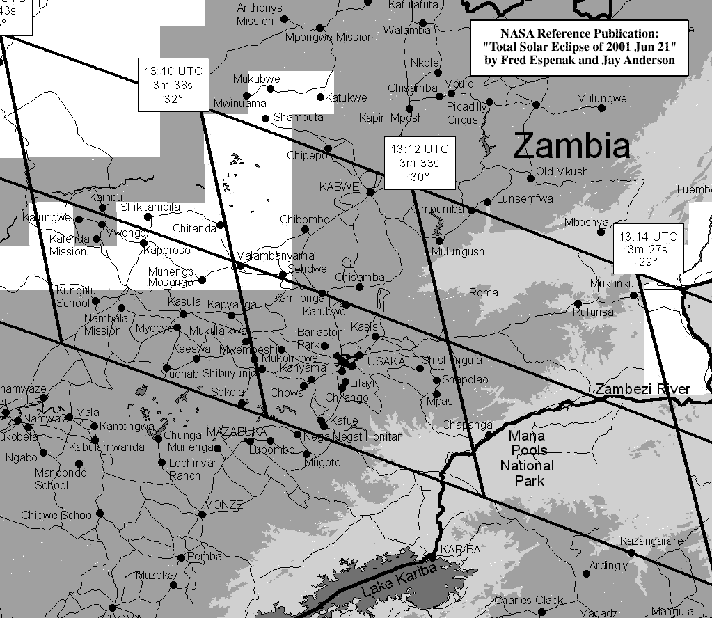
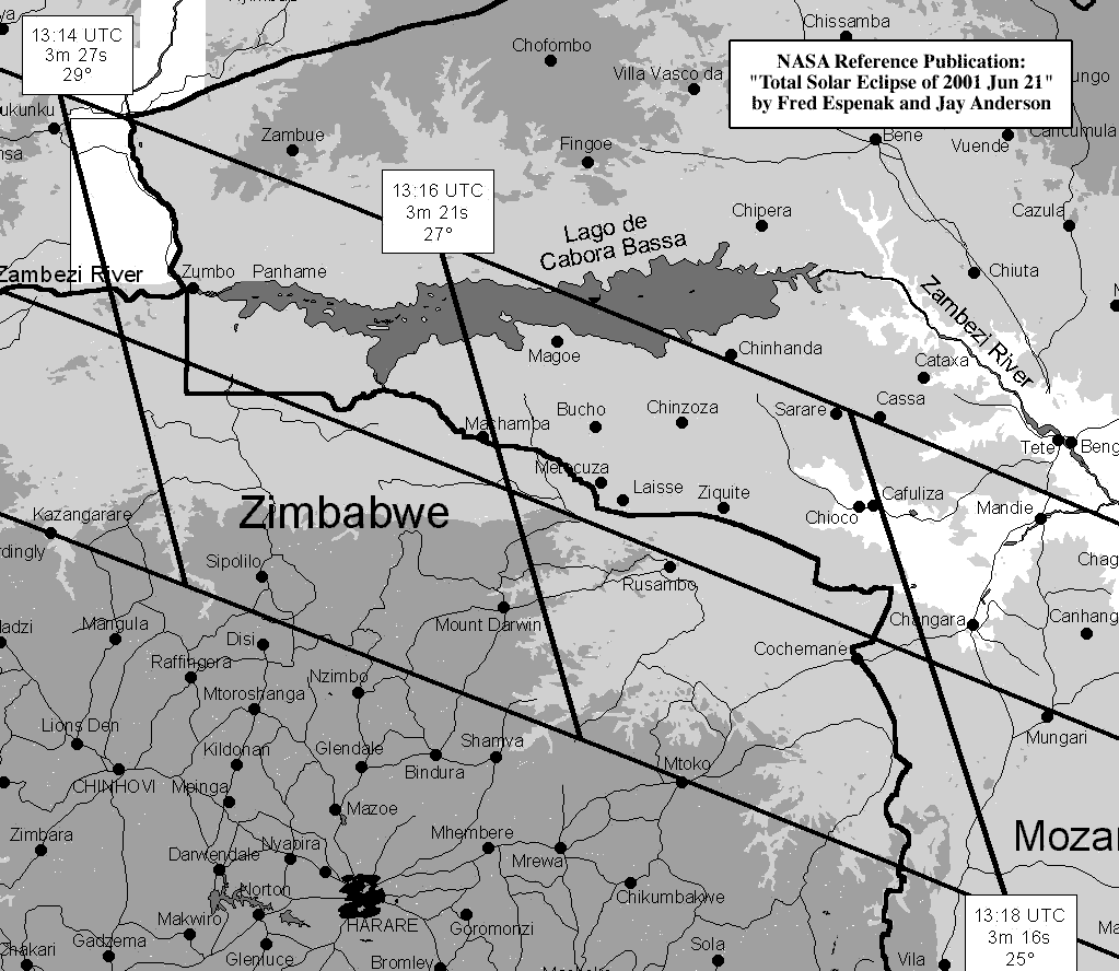
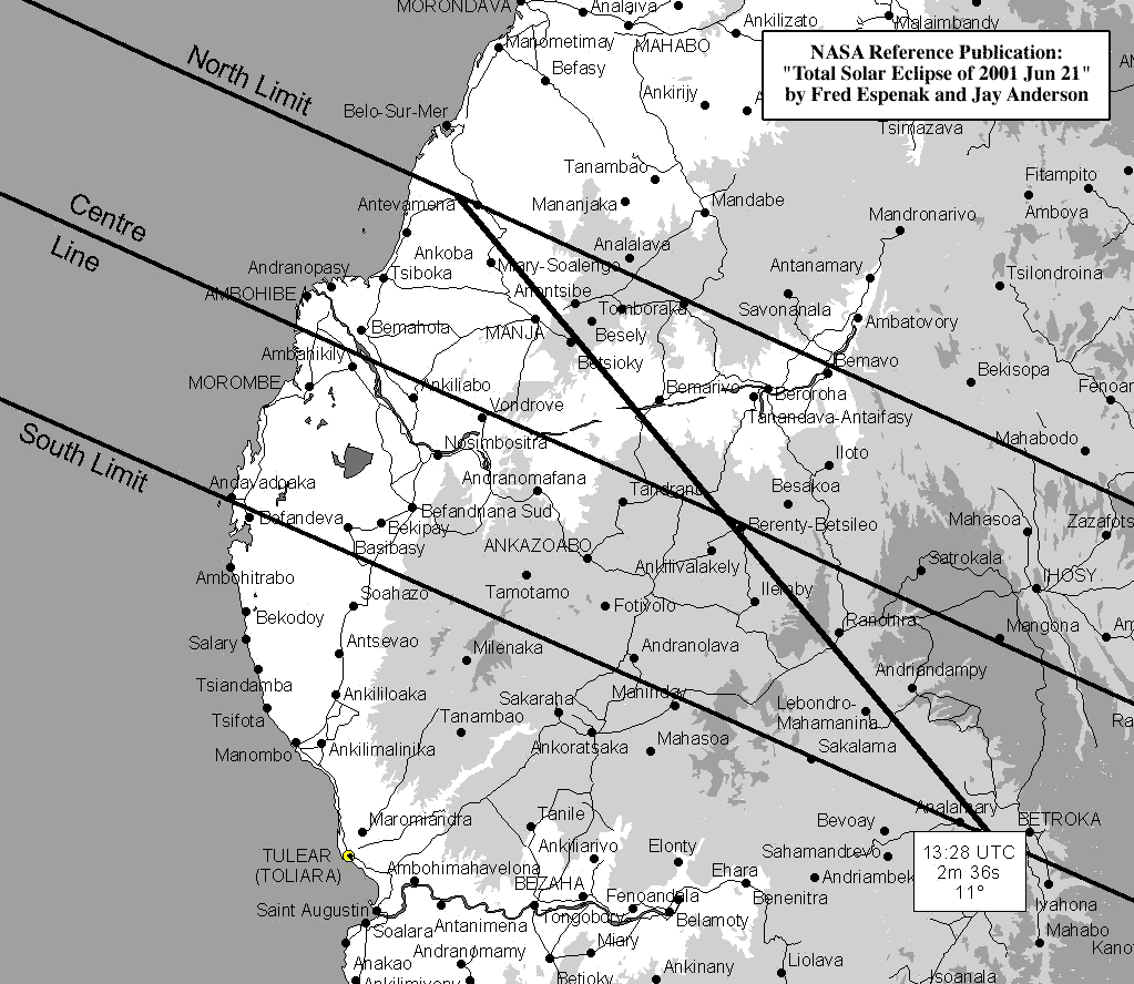
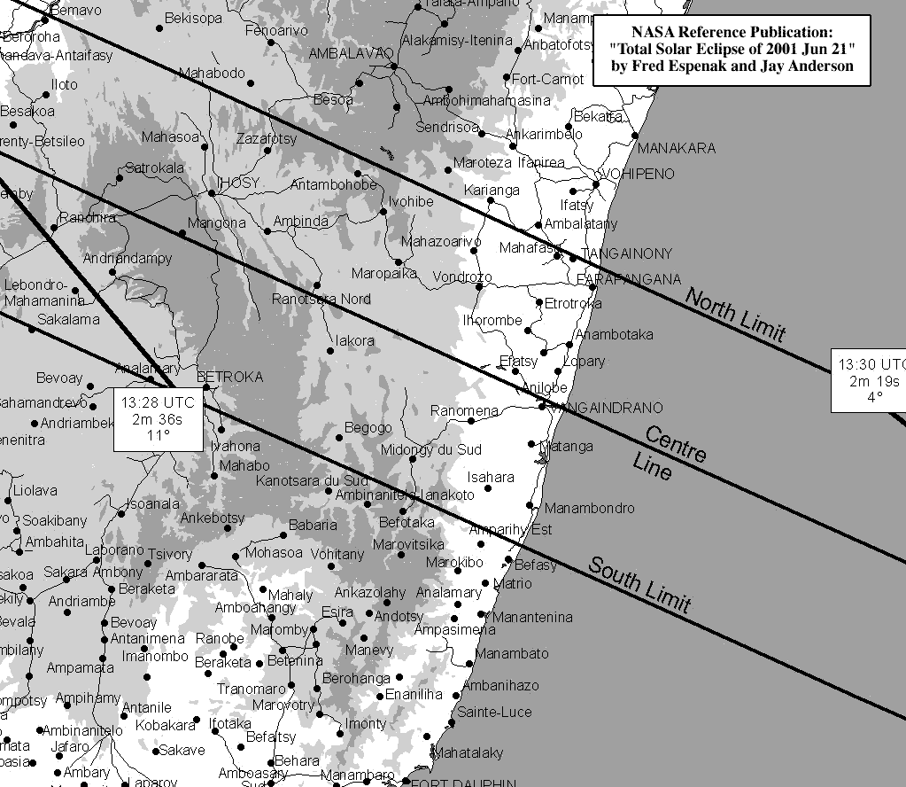
The path of totality has been plotted via custom software onto maps using a simple equidistant cylindrical projection scaled for the central latitude of each map. They all use high resolution coastline data from the World Data Base II (WDB) and World Vector Shoreline (WVS) data. These maps were chosen to isolate small regions along the land portion of the eclipse path. Curves of maximum eclipse and constant eclipse magnitude are included as well as the outline of the umbral shadow. A special feature of these maps are the curves of constant umbral eclipse duration (i.e., totality) which are plotted within the path. These curves permit fast determination of approximate durations without consulting any tables. Furthermore, city data from a recently enlarged geographic data base of over 90,000 positions are plotted to give as many locations as possible in the path of totality.
Note: You may need to set your printer to 50% reduction in order to print each figure on a single page.
These maps are adapted from NASA TP 1999-209484 "Total Solar Eclipse of 2001 June 21".
The path of totality has been plotted on a set of nine detailed maps. The maps are constructed from the Digital Chart of the World (DCW), a digital database of the world developed by the U.S. Defense Mapping Agency (DMA). The primary sources of information for the geographic database are the Operational Navigation Charts (ONC) and the Jet Navigation Charts (JNC) developed by the DMA. The original map scale of these maps was 1:1,000,000. Previous users of these NASA Reference Publications will be familiar with ONC and JNC charts as hard-copy versions were used to show the eclipse tracks in past studies.
Note: You may need to set your printer at 50% reduction to print each map on a single page.
These maps are adapted from NASA TP 1999-209484 "Total Solar Eclipse of 2001 June 21" .
Special thanks to Stig Linander for his expertise in compressing these maps into very small GIF files for fast downloads.
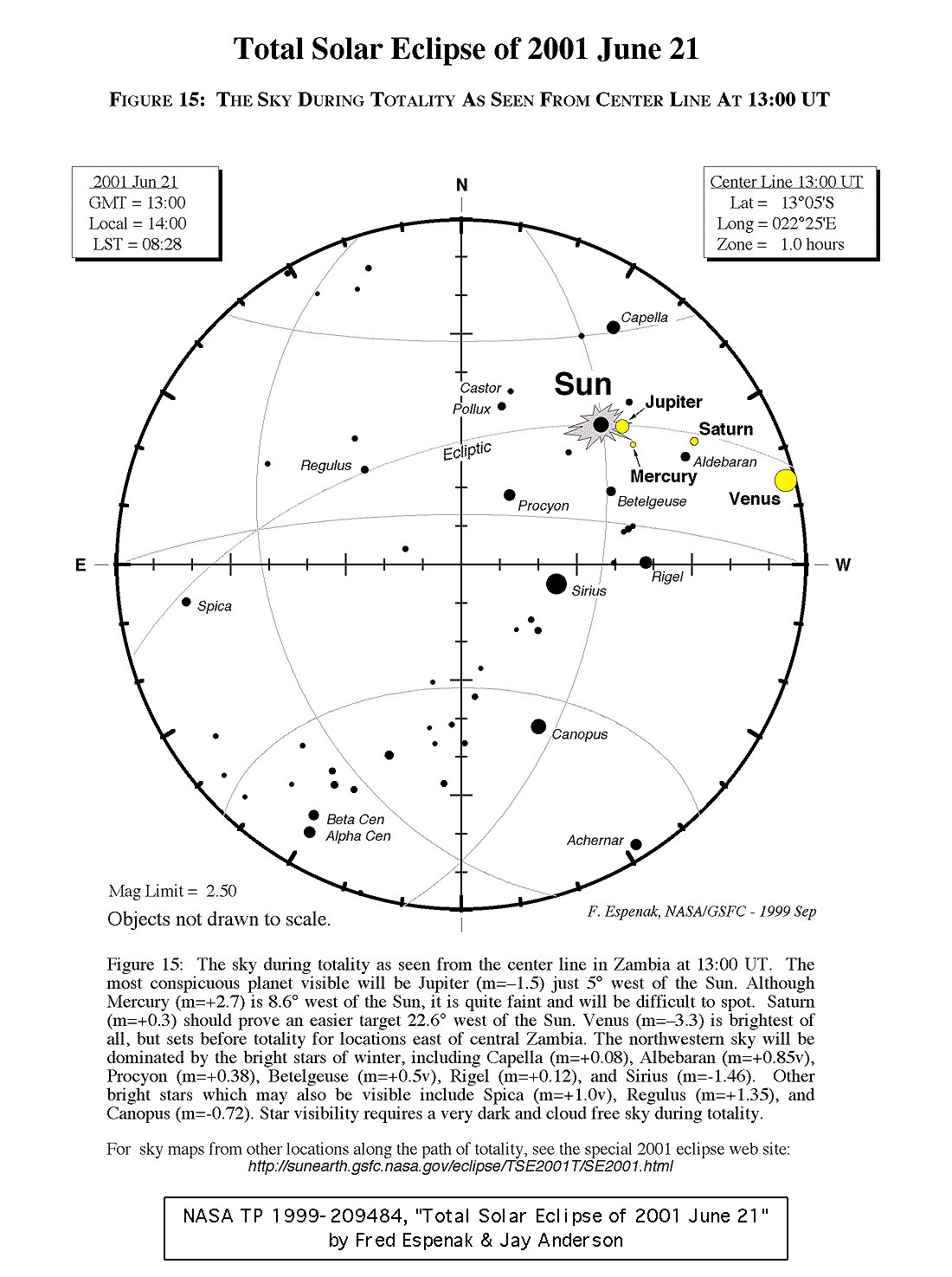
During totality, a number of bright planets and stars will be visible. Jupiter (m=�1.5) will be the most conspicuous planet located 5° west of the Sun. Mercury is faint (m=+2.7) but may be visible 8.6° west of the Sun if conditions are right. Saturn (m=+0.3) should prove an easier target 22.6° west of the Sun. Venus (m=�3.3) is brightest of all, but the planet is 45.3° west of the Sun and will be below the horizon for locations east of Angola.
A number of the brightest winter stars may also be visible during totality. Capella (m=+0.08) is 24° north of the Sun while Castor (m=+1.94) and Pollux (m=+1.14) stand 22° and 24° to the east. Procyon (m=+0.38) and Sirius (m=-1.46) are located 30° and 42° to the southeast, respectively. Betelgeuse (m=+0.5v) and Rigel (m=+0.12) are south at 16° and 34°, while Aldebaran (m=+0.85) is 21° to the west. Finally, Canopus (m=-0.72) lies high in the sky 76° due south. Star visibility requires a very dark and cloud free sky during totality.
Note: You may need to set your printer at 50% reduction to print each figure on a single page.
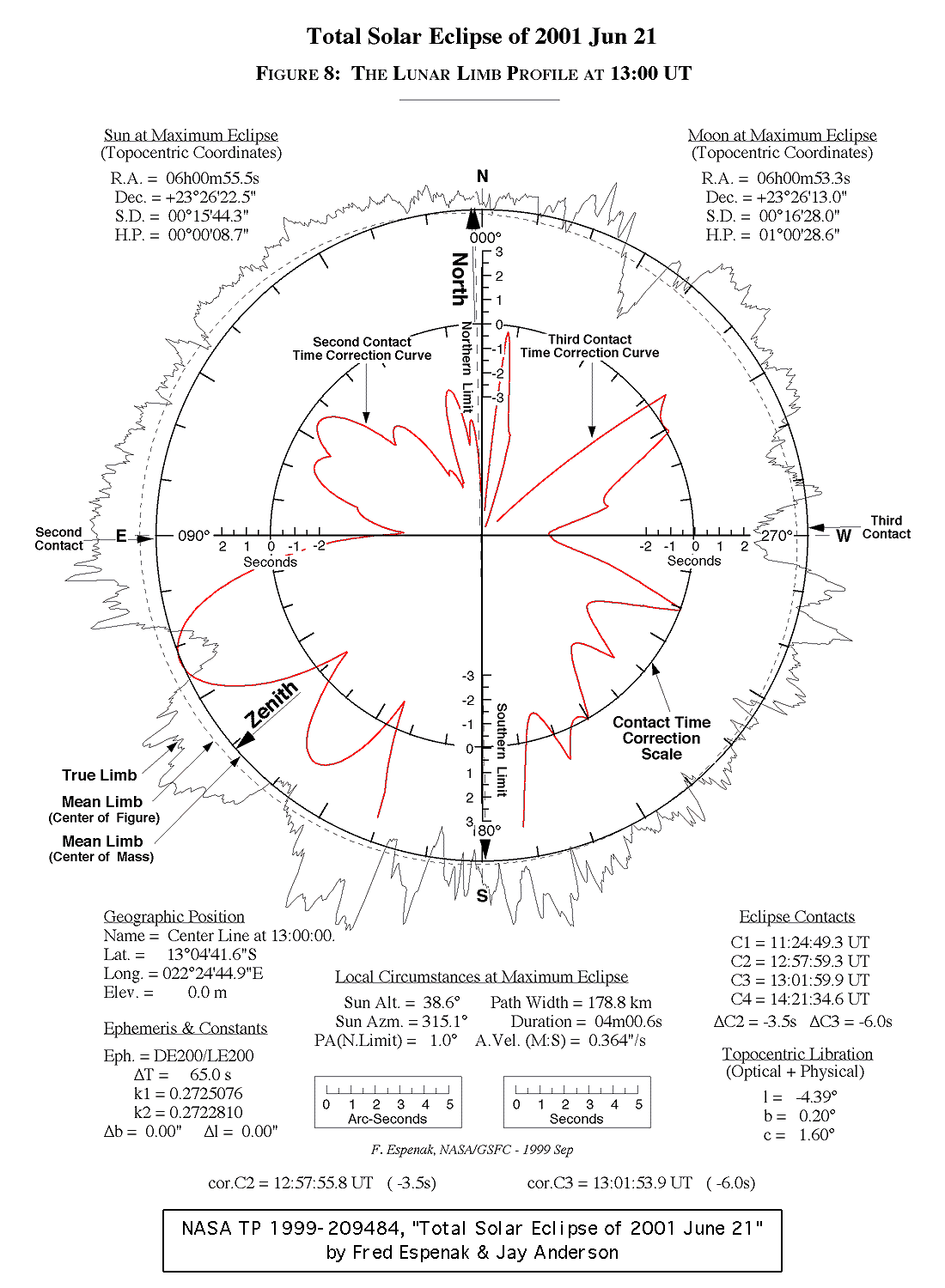
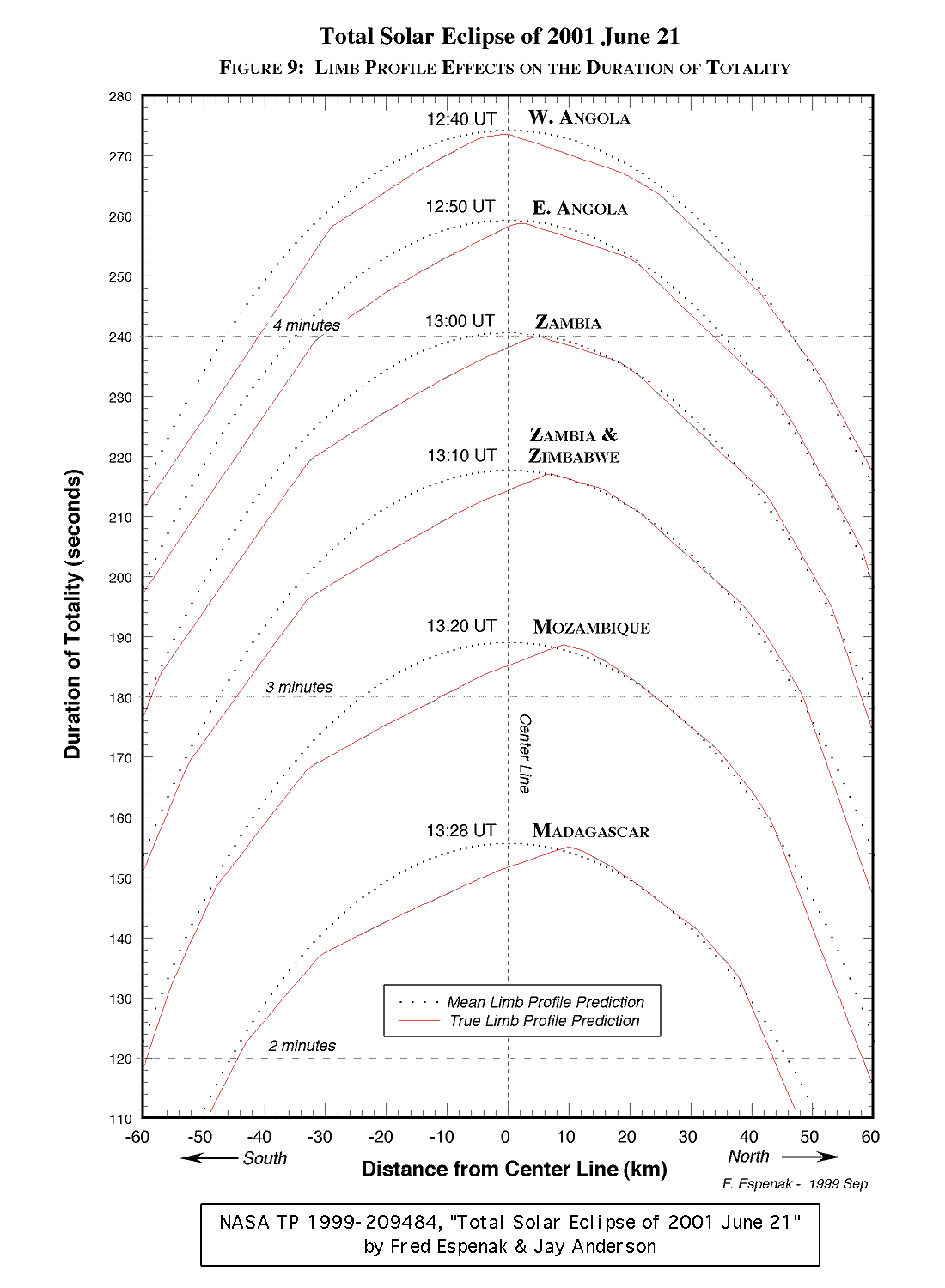
The limb profile of the Moon determines the appearance and duration of Baily's beads. The profile is also required in predicting the exact times of second and third contact, and the actual duration of totality.
Note: You may need to set your printer at 50% reduction to print each figure on a single page.
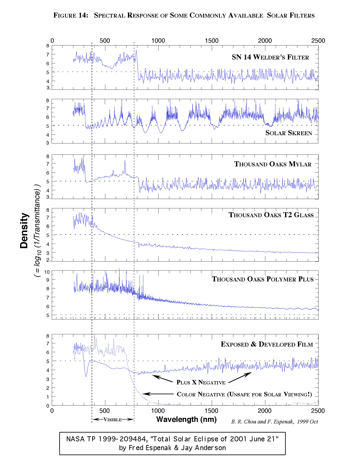
The partial pahses of a solar eclipse may only be viewed safely when using a specially manufactured solar filter.
Note: You may need to set your printer at 50% reduction to print each figure on a single page.
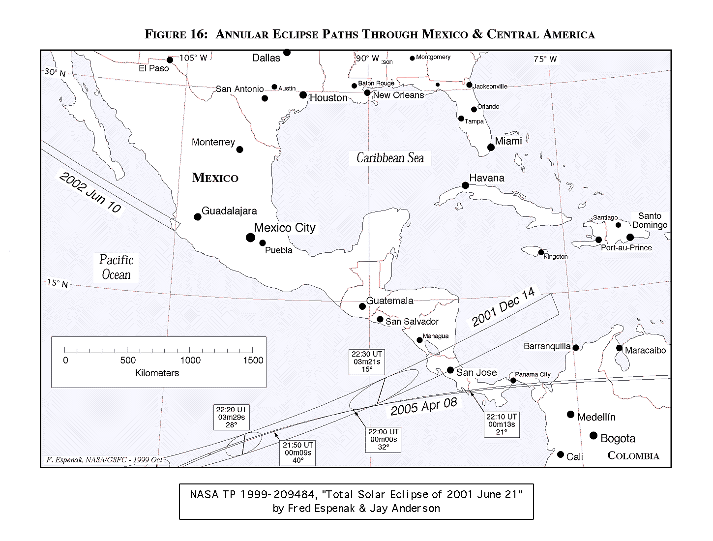
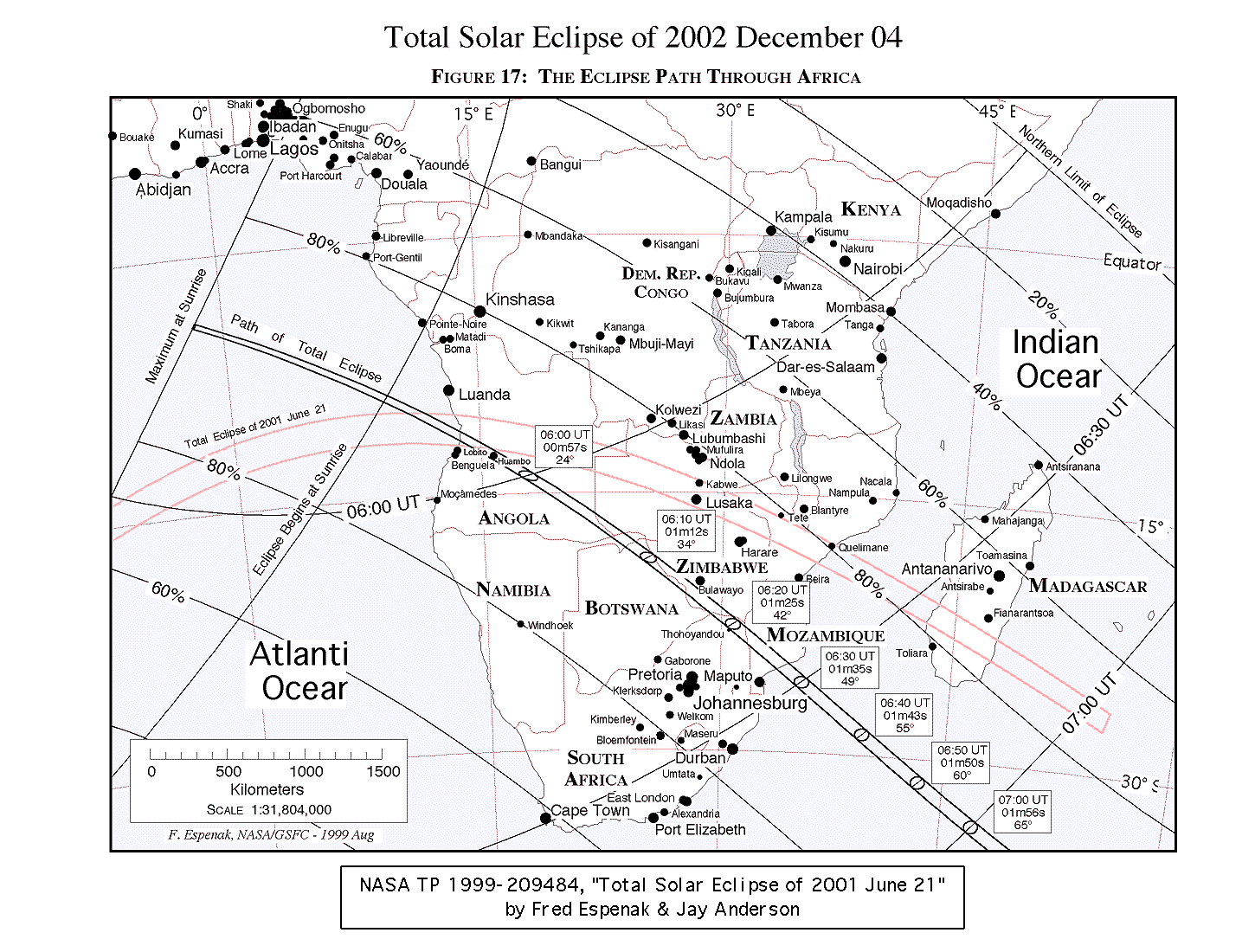
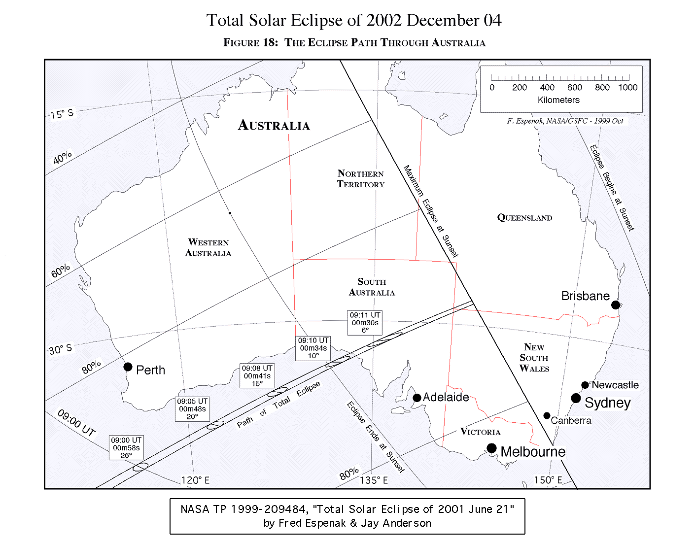
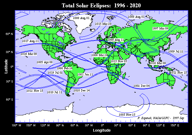
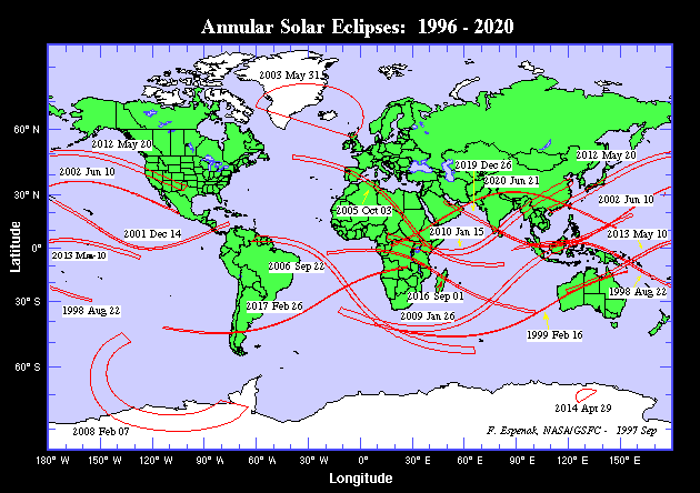
In the next several years, three annular eclipses of the Sun will be visible from Mexico and Central America. The next total solar eclipse occurs on 2002 Dec 04 and is visible from southern Africa and southern Australia.
Note: You may need to set your printer at 50% reduction to print each figure on a single page.
![]()
![]()
Permission is freely granted to reproduce this information and data when accompanied by an acknowledgment of the source:"From Total Solar Eclipse of 2001 June 21 by Fred Espenak and Jay Anderson, NASA"
If you have comments, suggestions, corrections and/or additions, please send them (along with the URL address of this page) to Fred Espenak
![]()

Eclipse Predictions & Webmaster: Fred Espenak Email: Fred.Espenak-1@nasa.gov Official NASA Representative: Dr. Drake Deming
Planteary Systems Laboratory - Code 693
|
|---|
Last revised: 2004 Nov 09 - F. Espenak