For most eclipses, weather prospects offer several choices. For instance, the previous total eclipse in 2006 had a very promising climatology in Saharan Africa, Egypt, and southern Turkey. The 2008 eclipse is more limiting in that the weather tends to be rather dismal along the majority of the track, even though the August 1 date comes at the peak of summer and summer sunshine. It is not until the path reaches southern Russia and northern China that the prospects for sunshine rise to values comparable to the 2006 total eclipse.
China, near the cities of Hami and Jiuquan, has the best prospects (over 70%) while southern Siberia, between Novosibirsk and the Mongolian border, offers about a 60% probability of success. Other locations tempt for their stunning scenery or travel off the beaten path, but eclipse-seekers in these areas will have to compromise with poorer weather prospects.
On August 1, temperatures in the Canadian Arctic have just passed their annual peak. The polar ice pack is retreating rapidly under the onslaught of continuous daylight, headed for its minimum in mid-September. Over southern and central parts of the archipelago, snow cover has melted away from the land and at Alert, the world’s most northerly settlement, has declined to barely a centimeter in depth. It is not a snow-free world however, as all Arctic settlements along the eclipse track can experience snowstorms in July and August—storms that can drop as much as 20 cm of fresh snow.
Cyclonic weather systems (lows) tend to frequent the lower latitudes of the Canadian islands, being more common along the north coast of the mainland near Cambridge Bay than farther north at Resolute, Grise Fiord, and Alert. The impact of these systems on cloudiness is rather muted as skies tend to be gray whether or not a cyclonic disturbance is in the vicinity. At Cambridge Bay, the frequency of days with heavy cloud (8–10 tenths) is 70% and at Resolute, 77%. A significant part of this cloudiness comes in the form of fog, which occurs across the archipelago with a frequency of between 20 and 30% in August.
The low-level cloudiness and fog are a consequence of the cooling of summer air masses as they pass over the cold Arctic Ocean waters, and suggests that conditions inland record greater amounts of sunshine than those at the coast. Satellite images for the region, however, usually show that the cloud cover simply blots out the landscape according to the weather of the day. Nevertheless, there is probably a small reward in moving inland a few kilometers in order to maximize the climatological probability of sunshine.
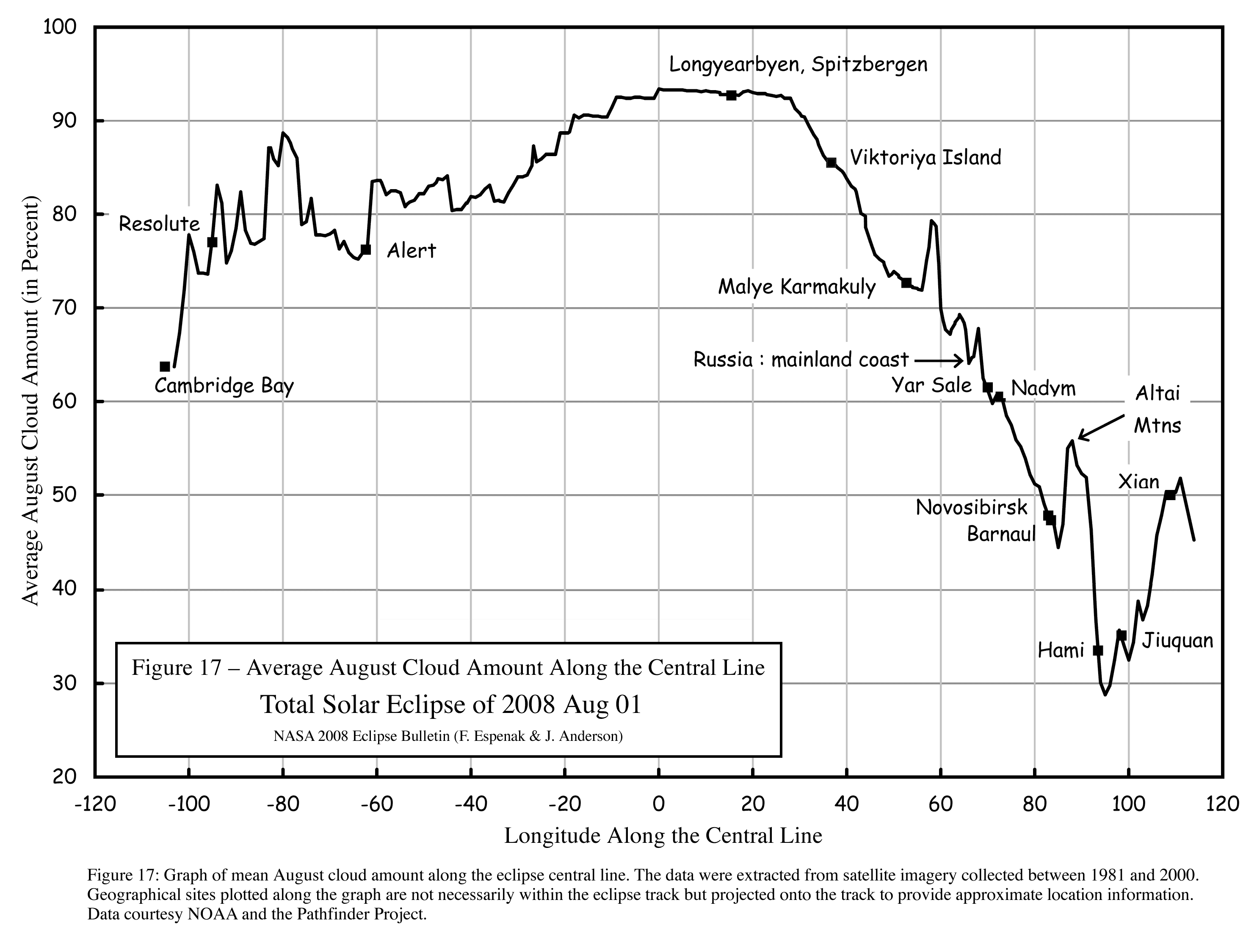
From a global perspective, cloud cover decreases southward, and so Cambridge Bay, close to where the eclipse begins, should be more inclined to a sunny day than any of the few stations farther north. This is seen quite dramatically in Figure 17, which shows the mean cloud cover along the central line as measured from polar-orbiting and geostationary satellites. The eclipse track near Cambridge Bay has a mean cloudiness of slightly below 65% compared to values in the mid–and upper 70 s for Resolute and Alert. This Cambridge Bay advantage, however, has a meager reflection in the observations of cloudiness from the surface (Table 18).
Hourly records of sunshine—probably the best indication of the prospects of seeing the eclipse—show only a small variation across the Canadian Arctic. At Alert and Cambridge Bay, the percent of possible sunshine is close to 33%; at Resolute, it is only 22% (Table 18). As all of these means are for the month of August, it seems sensible to take an average of July and August to arrive at a more representative value for eclipse day. After making this adjustment, the percent of possible sunshine rises to 40, 31, and 36% for Cambridge Bay, Resolute, and Alert, respectively.
The low altitude of the Sun over the Canadian Arctic is attractive for those who want to escape the endemic cloudiness by viewing from an airplane. The high frequency of low cloud is an advantage here, as the cloud top is more likely to be accessible to small aircraft with a limited ceiling. The low cloudiness—particularly the frequency of fog—has a downside, however, as Arctic flight schedules are notorious for being interrupted, sometimes for days on end, by poor visibilities in fog or occasional snowstorms. No seasoned traveler would visit the Canadian archipelago without leaving a few days leeway for bad weather on either side of scheduled events. Once again, Cambridge Bay has all the advantage here: the August climatological record shows a frequency of 9.5 with visibility less than 1 km compared to more than 73 at Resolute.
While cloud cover and weather statistics for northern Canada are only just sufficient to make an informed decision about a viewing site, those along the portion of the eclipse track from the north coast of Greenland to Spitsbergen Island are completely inadequate. Only a few expeditions have visited the region and satellite images are complicated by observational biases and poor viewing angles. Geostationary satellites cannot see much farther north than about 65° latitude, while polar-orbiting satellite observations are complicated by snow and ice fields that make the automatic identification of cloud difficult.
The Greenland ice cap has a high frequency of sunny skies because of an altitude that places it above the moist lower layers of the atmosphere. When air flows outward from the icy plateau, it is warmed by compression on its downhill journey to the ocean, and arrives at sea level with clear skies and (frequently) violent winds. An icebreaker offshore might be able to tap into one of these katabatic flows, as happened for the 2003 eclipse in Antarctica.
The satellite record represented in Figure 17 suggests that average cloud cover increases along the track from 80% near Alert, to 95% near Spitsbergen Island, in general agreement with other databases that have been compiled by expeditions over the years. The cloud cover is not particularly forgiving, as it tends to be opaque and relatively devoid of openings. There are no permanent surface observing sites in northern Greenland, though some automatic stations do provide temperature data from the ice cap.
The eclipse passes between the islands of Svalbard and Franz Josef Land, touching each one of these archipelagos only on the shadow’s northern and southern limits, respectively. This region is much cloudier than Canada’s Arctic islands, with mean cloud amounts that exceed 90% (Figure 17). Early explorers commented on the unending grayness of the region, which, unlike the more ice-bound regions above the 70th parallel, does not even give way to clearer skies in the winter months.
The explanation lies in the presence of an extension of the Atlantic Gulf Stream that feeds relatively warm water into the Barents Sea through the gap between Iceland and Norway. Warm Atlantic airstreams saturate quickly as they flow over the cold Arctic waters and the result is an extremely high frequency of low cloud, more than in any other parts of the high northern latitudes. The Barents Sea also has a relatively high frequency of cyclonic storms in August, though the strength of these low-pressure systems is much less than those that develop later in the year.
The graph in Figure 17 shows that the heaviest cloud cover of the entire track lies in the region surrounding Spitsbergen Island; in the surface station data, observing sites in Franz Josef Land have that dubious distinction. Ny Alesund, the only station in the area for which sunshine data are available, shows an average of 4.3 h of sunshine each day, a figure that translates into just 18% of the maximum possible. According to satellite data (Figure 17), the cloudiness along the central line declines steadily after the eclipse track passes 30° E longitude, dropping below 75% on the coast of Novaya Zemlya. Cloudiness spikes upward briefly as the eclipse path crosses the high terrain of Novaya Zemlya, but then continues its downward trend—a trend that continues until the Chinese border. Surface observations (Table 18) are not quite so dramatic, showing a more muted cloud-cover trend that drops only about 10% between Viktoriya Island in Franz Josef Land and Malye Karmakuly on Novaya Zemlya.
Novaya Zemlya and the islands that make up Svalbard and Franz Josef Land have prominent terrain that may provide some shielding from the endemic cloud cover of Arctic latitudes. Winds that blow downslope from higher ground or are diverted to flow around an island may carve holes in the cloud cover on the lee side of the terrain. It is a phenomenon that is usually very local in extent. The south side of Novaya Zemlya, being significantly larger and higher than the other islands and angled to block the prevailing northwesterly and northerly flows, is most likely to benefit from the lee side drying. It is not a major improvement, but brings mean cloudiness down to about 70%—a drop of nearly a fifth from the peak near Spitsbergen Island.
Eclipse expeditions that hope to watch from Arctic waters should head for the Kara Sea between Novaya Zemlya and the Yamal Peninsula (on the Russian mainland) in order to take advantage of the modest improvement in the cloud climatology.
While the Barents and Kara Seas lie in the path of cyclonic storms moving eastward from the Atlantic, the lows do not carry the punch of storms in the cold-weather season. Wind speeds around Novaya Zemlya average just over 15 km/h in August and seldom reach above 50 km/h. Wind speeds at Viktoriya Island, between Spitsbergen and Franz Josef Islands, are slightly stronger on average, but also peak at the 50 km/h mark. Wave heights reflect these lighter winds, being generally less than one meter and only occasionally above two.
Maximum temperatures all along the Arctic track rise only 5–10°C above the freezing point, reaching the warmest values on the bigger islands. Novaya Zemlya is warmer on the west side than on the east, as the west intercepts the Gulf Stream branch that reaches out from the Atlantic Ocean. This warmer air also carries a heavy moisture load and so the cloudiness on the windward side of the island is heavier than on the leeward side.
As the path of the lunar shadow moves southward across central Russia, it encounters a moist landscape of rivers, bogs, and small lakes. The surface provides a ready supply of moisture to be incorporated into passing weather systems. Most of these weather systems track north of the 60th parallel, but their associated frontal systems can sweep much farther south, even into China. The weather in the north has a very different character than that in the south. Above the 60th parallel, large weather systems with extensive mid- and upper-level cloud shields and steady precipitation are a common feature of the mid-summer months. Farther south, nearer to Novosibirsk, the weather systems become more convective in nature, with showers and thundershowers bringing the majority of the rainfall.
There is not a clear-cut distinction between the northern and southern cloud climates, but instead, a gradual transition as latitudes decline. In the satellite data, mean cloudiness diminishes steadily, from 65% along the north coast near Nadym to 47% near Barnaul (Figure 17). South of Barnaul cloud cover increases by nearly 10% over the rugged Altay Mountains that mark the boundary between Russia and China. Surface observations show the percent of possible sunshine climbing from 35% at Salekhard, to a more promising 54% at Novosibirsk and 57% at Barnaul.
The most likely eclipse destination in northern Siberia is Nadym, just below the Arctic Circle. A small community of 50,000 composed of imposing bastions of apartments, Nadym owes its existence to huge reserves of natural gas. As climate statistics are not available for Nadym, Tako-Sale or Salekhard can be substituted. In either case, cloud cover statistics are not encouraging, in large part because of the frequent presence of migrating low-pressure systems with their large cloud shields and sustained precipitation. In Figure 17, Nadym looks promising only when compared with sites much farther north.
Much of the summer precipitation in the southern portion of the Siberian track is in the form of convective showers arising during the passage of weak frontal systems. These frontal disturbances pass relatively quickly and are easily followed in satellite imagery by noting the areas of mid- and high-level cloudiness that usually accompany them. Such systems can bring a day or more of cloudiness, in contrast to less organized forms of convection that may persist for only an afternoon and evening. Whatever its nature, most days with rain are supported by some form of upper disturbance and eclipse expeditions should keep an eye on numerical-computer models, as these are quite reliable at forecasting the movement of the upper systems.
The Altay Mountains, with peaks rising above 4000 m, impose a substantial barrier between Russia and China and separate two very different climate regimes. Their altitude brings a sharp increase in cloudiness as air is forced to rise and cool, but the spectacular beauty of the area, with brilliant glaciers and snow-capped peaks, provides a powerful temptation to go to the border for the eclipse. The climate in the Altay is highly variable, with high, steeply sloped mountains alternating with deep valleys. The rugged terrain breaks holes in all but the most persistent weather systems, but the difficulty of travel and the limited horizon view make the task of finding a sunny spot a difficult one. Given the challenges, the most promising weather would seem to lie on the south side of the Altay, close to the border with Mongolia, where the climate is much drier.
Temperatures moderate significantly once the eclipse track leaves the Arctic coast for the interior of Siberia. August 1 is just past the warmest part of the year: maximum temperatures climb from an average of 13°C in the north to between 21 and 23°C near Novosibirsk and Barnaul. Rainfall is infrequent in the afternoon—on average about 15% of the hours around the time of the eclipse have precipitation reported. It is not a particularly breezy time of year (maximum winds seldom exceed 40 km/h), but strong thunderstorms can bring damaging gusts just as in North America or Europe. The likelihood of a thunderstorm during the afternoon ranges from less than 1% over the northern part of the track to between 3 and 5% south of Novosibirsk.
Novosibirsk is likely to be the staging point for eclipse expeditions to southern Siberia as it is a substantial metropolis (the third largest in Russia) with all of the services that come with a large population. The surrounding landscape is a mixture of forest and farmland, with good highways to the east, west, and south. Of particular interest is the highway that leads southward from the city toward Barnaul and the Mongolian border: it follows the central line very closely for the first 300 km and then more loosely for the remaining distance. The central line of the eclipse shadow misses Novosibirsk to the west, passing directly over its airport near the town of Ob.
Open spaces for eclipse observing are at a bit of a premium, but can be found with a little searching. The area is largely unpolluted, thanks to the vast Siberian wilderness, though occasional forest fires have been known to give a pink cast to the sky. The Novosibirsk Reservoir (informally, the Ob Sea), to the southwest of the city, is a large lake with a long dimension of over 100 km and a maximum width of nearly 20 km. The size of the lake and its cool waters play havoc with convective clouds—small and medium-sized buildups dissipate rapidly as soon as they cross from land to water, often opening substantial holes in the cloud cover when conditions are right. Eclipse-viewing sites situated on the lee side (which changes with the wind direction) of the lake shore could derive a substantial benefit from this effect, especially as the central line crosses the lake only 20 km from Novosibirsk. The suppression of cumulus cloudiness usually extends a short distance inland on the lee shore.
Examination of the hourly cloud-cover statistics for Novosibirsk shows a strong increase in broken cloudiness during the afternoon hours and a corresponding decrease in both scattered and overcast cloud cover. This pattern is almost certainly a climatological reflection of the buildup of cumulus cloud and suggests that a site on the lake should improve odds (i.e., the percent of possible sunshine) by 5% to 10% above the statistics for Novosibirsk airport, which lies 24 km to the north of the lake. Showery weather typically arrives with a southerly component to the wind, and so the north side of the lake is slightly more favored than the south.
The center of the eclipse track crosses the town of Leninskoye on the north side of the lake and Sosnovka on the south, both of which are easily accessible from Novosibirsk. Sosnovka is a tiny community located next to a creek of the same name. The terrain is open to the southwest and to the north across the lake, providing an excellent view of the oncoming shadow, and the surrounding countryside is largely made up of open farmland. There is no beach along the shore, but an open space next to the waterline affords an place for viewing the eclipse. Leninskoye, on the north side of the lake, has the attraction of a large beach that permits an excellent view southward. The beach, or the high ground that backs the beach, offers more space than appears available at Sosnovka. Leninskoye itself has limited facilities, but is undergoing rapid development as residents from Novosibirsk build dachas (country houses) in the community.
Closer to Novosibirsk, the town of Ob—essentially an airport suburb—nearly straddles the central line, but there are few open spaces to catch a good view of the horizon and the ambiance is overly industrial with noisy traffic on the highway leading to Omsk. South of Ob lies a stretch of farmland with open pastures mixed with patches of forest.
As the eclipse track crosses the Altay Mountains into China, there is an abrupt change in climatology, in part because of the blocking effects of the mountains. Northern China is bone-dry and much sunnier. The eclipse track passes between the Taklimakan and Gobi Deserts, following the track of the ancient Silk Road to Xi’an, and then settling into the sunset near Luohe. While over northern China the track skips along the Mongolia-China border, follows the gradually smaller peaks of the Altay Mountains, and then crosses onto a rocky plateau between mountain ranges as it passes Hami and Jiuquan. Here, at these latter stations, the influence of the deserts is felt most strongly, and the prospects for sunshine reach their peak.
Mean cloud amount as measured by satellite (Figure 17) drops nearly 20% from the Altay Mountain maximum, to a minimum of 28% at a location on the center line to the southeast of Hami. Farther south, past Jiuquan, the track begins to feel the influence of the monsoon moisture that haunts central China in August, and the cloudiness rebounds to 50% at Xi’an. This quick variation in the cloud statistics, leaves eclipse watchers with an excellent location from which to view the spectacle.
Surface-station reports mimic the conclusions of the satellite data. From Barnaul to Hami, the percent of possible sunshine rises by 20% to a maximum of 76% (Table 18). Precipitation for August drops to a very few millimeters (Table 19) and average daytime temperatures climb to the upper 20s (°C). Even winds are on our side, with peak values averaging only 25 km/h along the Silk Road, and easing concerns about dust storms. For at least a short interval, the weather conditions for the eclipse seem almost perfect.
In spite of its favorable average climatology, northern China is not without its weather systems and occasional heavy cloudiness in August. Most of the weather systems are small upper disturbances that move across the Altay Mountains from Kazakhstan or Russia. The dryness of the air over northern China usually means that these disturbances are stripped of their low-level cloud, but the remaining higher clouds are quite capable of masking the Sun and spoiling the eclipse. As with similar systems over Russia, high clouds can be readily detected in satellite imagery and predicted by computer models.
The city of Hami lies on the eastern fringes of the Tarim Pendi, the great basin that holds the Taklimakan Desert. To the east of Hami is a minor branch of the Tien Shan Mountains, the Karlik Shan, with peaks that reach nearly 5000 m. While maps may barely show the range, from the city, it is a not-too-distant spectacle of snow-capped peaks, frequently topped with a fringe of convective cloud. The central line is some distance from Hami, on the far side of the Karlik peaks, on a pleasant grassland plateau at an altitude nearly 2000 m above sea level.
The road from Hami to the mountains is a ruler-straight highway that heads northeast from the city. The south limit of the eclipse is on the outskirts of Hami; the foot of the mountain range is 35 km distant. The mountains begin abruptly, first with a gentle climb into a gorge, and then with gradually increasing slopes and quick switch-back curves, but the paved highway is in excellent condition and after an hour or so of travel, emerges from the gorge to show a spectacular plateau—the Barkol grassland. As the highway turns southward toward Yiwu, the largest community near the central line, the peaks of the Karlik guard the right-hand side. To the left is a line of lower hills, converging slowly toward the highway. The left-side eastern hills are mostly cloud free—the small amount of cumulus present will dissipate during the eclipse. The higher Karlik peaks in the west, however, are topped with towering convective clouds, some raining on the steep slopes above the grassland plateau. The winds of the day push the remnants of these mountain showers toward the highway, but the downslope run from the peaks causes them to dissipate on their journey and the day is scarcely interrupted by the leftover patches that finally reach the highway.
At Yiwu, a modern city of brightly colored apartments, the eastern hills finally pinch off the highway. The town is nestled against these dull-brown hills, and as the road turns from southeast to northeast toward the central line, it enters a winding gorge, at one moment open to a wide expanse of sky, and the next, confined between narrow hills and roadside trees. The central line is in the gorge: the sky is open to a good view of the eclipse, but the horizons are blocked in all directions and the space is very limited for a group of any size. Beyond the central line, several kilometers distant, the gorge opens onto a flat gravely plain allowing a view of the whole sky.
The surface-station climatology at Hami (Table 18) is not representative of the conditions along the central line, as the mountain cloudiness is barely reflected in the observations from the city. The scattered-to-broken cloudiness encountered on the plateau is probably fairly common all along the eclipse track, at least wherever the track lies in the proximity of higher ground. Observations farther north near Urumqi seem to support this conclusion; however, the satellite-derived cloud statistics reflect the mountain cloud cover more accurately. While the statistics for Hami are more optimistic than is actually the case on the eclipse track, there seems little reason to dispute the satellite measurements that give a strong nod to the Hami-Jiuquan area. Perhaps the best location is northeast of Anxi, near the community of Gongpoquan where the terrain is lowest and the mountain-induced cloudiness at a minimum, but local information suggests that this is a military area with restricted access.
Cloud conditions on the eclipse track cannot be easily viewed from Hami, though the cloud on the Karlik range is readily visible from the city. Only a trip to the plateau will permit the eclipse traveler to judge the conditions on eclipse day, but the cloud is so highly variable, unless a major disturbance is in the area, that it seems unlikely that the eclipse would not be visible somewhere on the Barkol grassland. The extent and direction of motion of the mountain cloud will depend on the weather on eclipse day and must be assessed at that time.
Xi’an lies on the edge of the eclipse path, in a region with a discomforting humidity, poorer prospects for cloudiness, and a disconcerting level of pollution and haze. The eclipse here will be very low—barely 4° above the horizon. Based on recent experience, the eclipse will not be visible from the city, as the Sun disappears into the smog while at a considerable altitude, perhaps as much as 10°. Outside the city, on the central line to the north, skies will be cleaner, but the view will still be severely limited by haze and humidity.
The two main sources of weather information for short-range planning (a few days to hours) are satellite imagery and numerical models of the atmosphere. Both of these can be found for nearly all parts of the eclipse track and links to a selection of distribution sites are given in the following sub-sections. The high latitude of much of the eclipse track limits the utility of geostationary images over Russian and Canada as the scene is wrapped over the curve of the Earth. Over the first half of the shadow track, downward-looking polar-orbiting satellites must be utilized to see the cloud patterns. Such satellites cannot provide the same frequency of coverage as their geostationary cousins and wide areas can only be shown by assembling strips of images side-by-side over a period of several hours, reducing the timeliness of the information.
Model data is even more limited over Russian and China even though most national meteorological centers configure their numerical models to run across the entire globe. Fortunately, a few sites do provide access to global output to help with the medium-range planning leading up to eclipse day. It is important to remember that numerical models have serious deficiencies, especially in data-sparse regions and the predictions should be backed up by a careful assessment of the real weather situation.
The weather options for the 2008 eclipse are limited: the best prospects are in southern Russia or northern China. By selecting a site along the shores of the Novosibirsk Reservoir or in the Altay Mountains near the Mongolian border, the climatological probability of seeing the eclipse may reach as high as 60% in Russia. In China, where a rugged terrain brings more cloudiness than suggested by the climate observing sites, the probability is likely in the 70% range. Elsewhere, eclipse chasers will have to trade grand Arctic and Siberian adventures and spectacular scenery for poorer weather prospects.
