Eclipses During 2008
Fred Espenak
To Be Published in Observer's Handbook 2008, Royal Astronomical Society of Canada
During the year 2008, two solar and two lunar eclipses occur as follows:
- 2008 Feb 07: Annular Solar Eclipse
- 2008 Feb 21: Total Lunar Eclipse
- 2008 Aug 01: Total Solar Eclipse
- 2008 Aug 16: Partial Lunar Eclipse
Predictions for the eclipses are summarized in Figures 1, 2, 3, 4, 5, and 6. World maps show the regions of visibility for each eclipse. The lunar eclipse diagrams also include the path of the Moon through Earth's shadows. Contact times for each principal phase are tabulated along with the magnitudes and geocentric coordinates of the Sun and Moon at greatest eclipse.
All times and dates used in this publication are in Universal Time or UT. This astronomically derived time system is colloquially referred to as Greenwich Mean Time or GMT. To learn more about UT and how to convert UT to your own local time, see Time Zones and Universal Time.
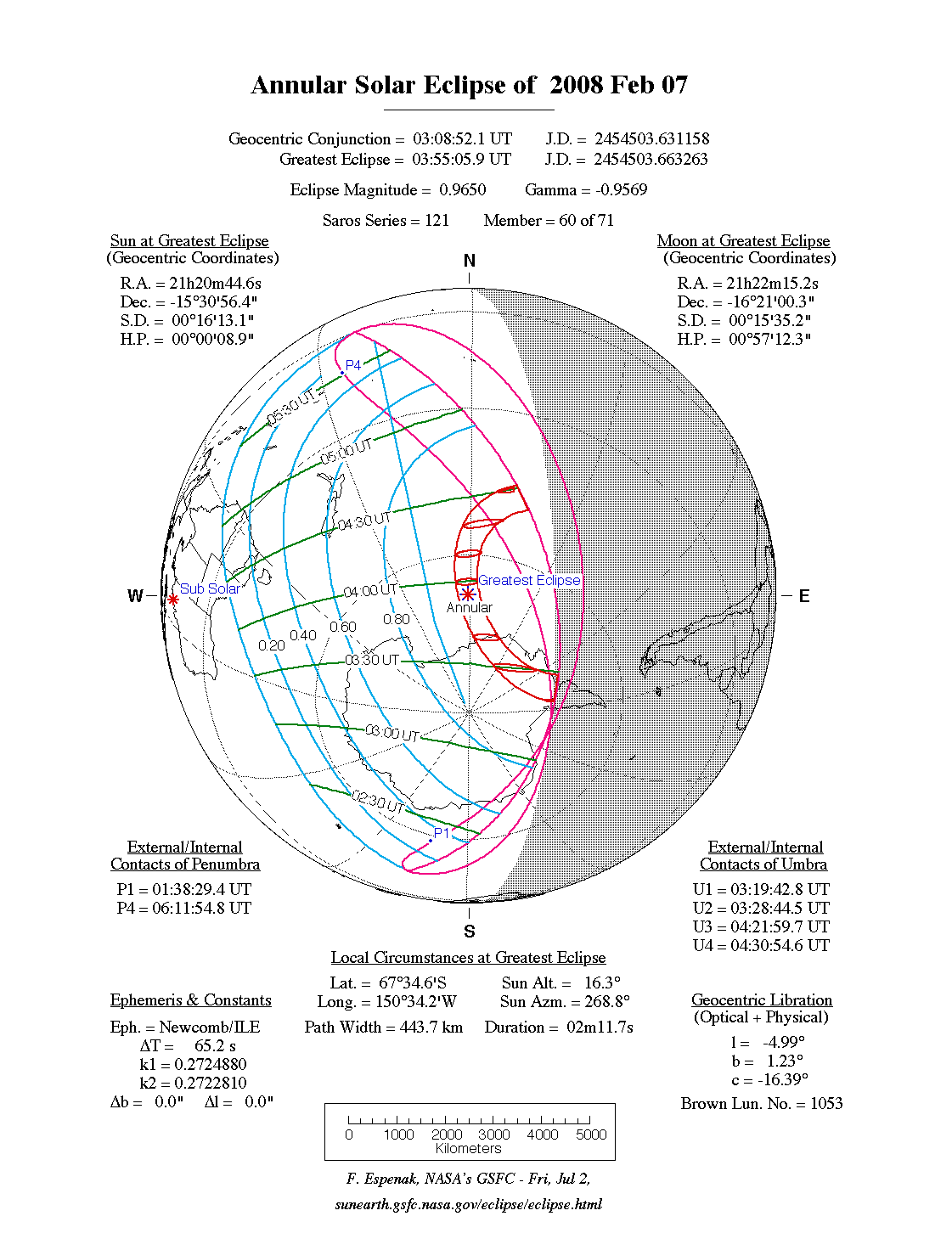
Annular Solar Eclipse of February 07
The first solar eclipse of 2008 occurs at the Moon's ascending node in Capricornus. An annular eclipse will be visible from a wide track, that traverses Antarctica and southern regions of the Pacific Ocean. A partial eclipse will be seen within the much larger path of the Moon's penumbral shadow, which includes the southeastern third of Australia, all of New Zealand and most of Antarctica (Figure 1).
The annular path begins in Antarctica at 03:20 UT when the Moon's antumbral shadow meets Earth and forms a 581 kilometre wide corridor near the base of the continent's peninsula region. Traveling westward, the shadow quickly crosses Antarctica and turns north as it heads into the Pacific. Greatest eclipse[1] takes place at 03:55:05 UT when the eclipse magnitude[2] will reach 0.9650. At this instant, the annular duration is 2 minutes 12 seconds, the path width is 444 kilometres and the Sun is 16° above the featureless horizon of the open ocean. The central track continues north before gradually curving to the east where it ends at local sunset at 04:31 UT. During its 1 hour 10 minute flight across our planet, the Moon's antumbra travels approximately 5,600 kilometres and covers 0.59% of Earth's surface area. Path coordinates and central line circumstances are presented in Table 1.
The most unusual characteristic of this eclipse is that it begins and ends along Earth's sunset terminator. Most eclipse paths that travel from west to east. However, the 2008 annular eclipse path begins by running east to west and slowly turns north before curving west to east near its terminus.
Partial phases of the eclipse are visible primarily from eastern Australia, New Zealand and the South Pacific. Local circumstances for a number of cities are listed in Table 2. All times are given in Universal Time. The Sun's altitude and azimuth, the eclipse magnitude and obscuration are all given at the instant of maximum eclipse.
This is the 60th eclipse of Saros 121. The series began with the first of six partial eclipses on 0944 Apr 25. The first central eclipse was total in the Northern Hemisphere on 1070 Jul 10. It was followed by 41 more total eclipses before the series produce two hybrid eclipses in 1827 and 1845. The first annular eclipse of the series occurred on 1863 Nov 11. The series will produce 11 annular eclipses the last of which is 2044 Feb 28. This means there are only two more central eclipses after the 2008 eclipse. The series terminates on 2206 Jun 07 after 9 more partial eclipses. Complete details for Saros 121 may be found at:
http://eclipse.gsfc.nasa.gov/SEsaros/SEsaros121.html
Click for special web page on the Total Lunar Eclipse of 2008 Feb 21
Total Lunar Eclipse of Feb 21
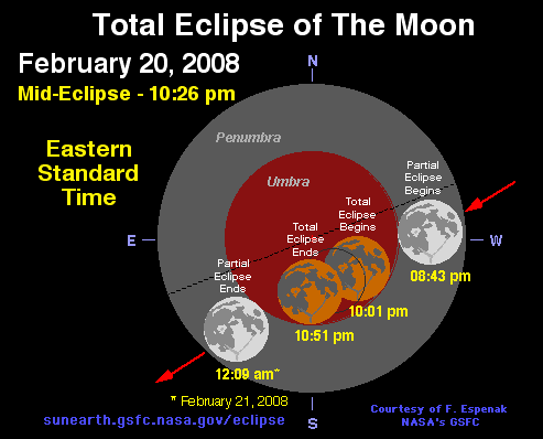
(Note: The Feb 21 date used here corresponds to the Universal Time of greatest eclipse. However, observers throughout North and South America will actually see the eclipse on the evening of Feb 20. For more information see Special 2008 Lunar Eclipse Page).
The first lunar eclipse of 2008 is perfectly placed for observers throughout most of the Americas as well as western Europe. The eclipse occurs at the Moon's descending node, midway between perigee and apogee. During the eclipse, Saturn lies about 3° northeast of the Moon and shines brightly (mv = +0.2) because it is near opposition.
The Moon's orbital trajectory takes it through the southern half of Earth’s umbral shadow. Although the eclipse is not central, the total phase still lasts nearly 51 minutes. The Moon’s path through Earth’s shadows as well as a map illustrating worldwide visibility of the event are shown in Figure 2. The timings of the major phases of the eclipse are listed below.
Penumbral Eclipse Begins:   00:36:35 UT
Partial Eclipse Begins:     01:43:19 UT
Total Eclipse Begins:       03:01:10 UT
Greatest Eclipse:           03:26:05 UT
Total Eclipse Ends:         03:50:57 UT
Partial Eclipse Ends:       05:08:47 UT
Penumbral Eclipse Ends:     06:15:39 UT
At the instant of greatest eclipse (03:26 UT) the Moon lies near the zenith for observers in French Guiana. At this time, the umbral magnitude peaks at 1.1062 as the Moon’s northern limb passes 7.2 arc-minutes south of the shadow’s central axis. In contrast, the Moon’s southern limb lies 3.3 arc-minutes from the southern edge of the umbra and 38.4 arc-minutes from the shadow centre. Thus, the northern half of the Moon will appear much darker than the southern half because it lies deeper in the shadow. Since the Moon samples a large range of umbral depths during totality, its appearance will change dramatically with time. It is not possible to predict the exact brightness distribution in the umbra, so observers are encouraged to estimate the Danjon value at different times during totality (see Danjon Scale of Lunar Eclipse Brightness). Note that it may also be necessary to assign different Danjon values to different portions of the Moon (i.e., north vs. south).
During totality, the spring constellations are well placed for viewing so a number of bright stars can be used for magnitude comparisons. Regulus (mv = +1.40) is 3° northwest of the eclipsed Moon, while Procyon (mv = -0.05) is 40° to the west, Spica (mv = +0.98) is 51° to the southeast, and Arcturus (mv = -0.05) is 58° to the northeast. Alphard or Alpha Hya (mv = +1.99) is 23° to the southwest and Saturn (mv = +0.2) is just 3° to the northeast of the Moon.
The entire event is visible from South America and most of North America. Observers along North America's west coast miss the early stages of the partial eclipse because it begins before moon rise. Alaskans in Anchorage and Fairbanks experience moonrise during totality but bright evening twilight will make it difficult for sourdoughs to view the event. Western Europe and northwest Africa also see the entire eclipse. Further to the east (east Africa and central Asia), the Moon sets before the eclipse ends. None of the eclipse is visible from eastern Asia or Australia.
Table 3
lists predicted umbral immersion and emersion times for 20 well-defined lunar craters. The timing of craters is useful in determining the atmospheric enlargement of Earth’s shadow (see Crater Timings During Lunar Eclipses).For more information see Special 2008 Lunar Eclipse Page.
Total Solar Eclipse of August 01
On Friday, August 01, a total eclipse of the Sun is visible from a narrow corridor that traverses half the Earth. The path of the Moon’s umbral shadow begins in Canada and extends across northern Greenland, the Arctic, central Russia, Mongolia, and China where it will end at sunset [Espenak and Anderson, 2006]. A partial eclipse is seen within the much broader path of the Moon’s penumbral shadow, which includes northeastern North America, and most of Europe and Asia (Figure 3).
The path of totality begins in northern Canada, where the Moon’s umbral shadow first touches down in the province of Nunavut at 09:23 UT (Figure 4). Along the sunrise terminator in Queen Maud Gulf, the duration is 1min 30s from the centre of the 206km wide path. Traveling over 0.6km/s, the umbra quickly sweeps north across southern Victoria Island, Prince of Wales Island and Northern Somerset Island. The shadow's northern limit clips the southeastern corner of Cornwallis Island and just misses the high Arctic town of Resolute. The nearly 200 residents of this isolated settlement will witness a partial eclipse of magnitude of 0.997 at 09:26 UT with the Sun 7° above the horizon.
Continuing on its northeastern trajectory, the umbra crosses Devon Island and reaches the southern coast of Ellesmere Island. The central line cuts across Nares Strait as the shadow straddles Ellesmere Island and Greenland. Canada's remote outpost Alert, the northernmost permanently inhabited place on Earth, lies near the northern limit of the eclipse track and experiences 43s totality with the Sun at 16° altitude at 09:32 UT.
After crossing northern Greenland, the track passes between Franz Josef Land and Svalbard. By the time the central line reaches the northern coast of Novaya Zemlya (10:00 UT), the duration is 2min 23s with the Sun at 31°. The track crosses both the island and the Kara Sea before reaching the Yamal Peninsula and the Russian mainland.
The instant of greatest eclipse occurs at 10:21:07 UT (latitude 65° 39'N, longitude 72° 18'E) when the axis of the Moon’s shadow passes closest to the centre of Earth (gamma = +0.8307, where gamma is the minimum distance of the Moon’s shadow axis from Earth’s centre in units of equatorial Earth radii). Totality reaches its maximum duration of 2min 27s, the Sun’s altitude is 34°, the path width is 237km and the umbra’s velocity is 0.507km/s.
During the next hour, the Moon's umbra works its way across central Asia (Figure 5). The shadow gradually picks up speed and its course changes from south-southeast to nearly east at its terminus. Novosibirsk, Russia's third most populous city, lies only 18km from the central line. The midpoint of Novosibirsk's 2min 18s total eclipse occurs at 10:45 UT with the Sun's altitude at 30°. Three and a half minutes later, Barnaul is plunged into a 2min 16s total eclipse.
The centre of the track follows the China-Mongolia border for several hundred kilometres while the central duration and the Sun's altitude both decrease. From Altay, China, the total eclipse begins at 10:59 UT and lasts 1min 25s with the Sun 25° above the horizon. Across the border, western Mongolia is very sparsely populated and the Altan Mountains bring cloudiness to the area. Ten minutes later, the umbra just misses Hami, China where a deep partial eclipse of magnitude 0.998 occurs at 11:10 UT. This region in northwest China is noteworthy because it offers some of the most promising weather prospects along the entire eclipse path. Its position between the Gobi Desert to the east and the Talikmakan Desert to the west spares it from the monsoon systems that affect much of Southeast Asia during the summer months.
During the final ten minutes of the umbra's track, it quickly sweeps across northern China as the duration of totality and the Sun's altitude decrease. The major city of Xi'an straddles the southern limit where maximum eclipse occurs with the Sun just 4° above the horizon. From the central line 106 km to the north, the duration of totality still lasts 1min 35s. Seconds later, the axis of the Moon's shadow lifts off Earth and the central eclipse ends (11:20 UT). Over the course of 2 hours, the Moon’s umbra travels along a path approximately 10,200 km long and covers 0.4% of Earth’s surface area. Path coordinates and central line circumstances are presented in Table 4.
Partial phases of the eclipse are visible from most of Asia, northern Europe and northern Canada. Local circumstances for a number of cities are listed in Table 5. All times are given in Universal Time. The Sun's altitude and azimuth, the eclipse magnitude and obscuration are all given at the instant of maximum eclipse.
This is the 47th eclipse of Saros 126. The series began with the first of eight partial eclipses on 1179 Mar 10. The first central eclipse was annular in the Southern Hemisphere on 1305 May 24. It was followed by 27 more annular eclipses before the series produce three hybrid eclipses in 1828, 1846 and 1864. The first total eclipse of the series occurred on 1882 May 17. The series will produce 10 total eclipses, the last of which is 2044 Aug 23. Thus, there are only two more central eclipses after the 2008 eclipse. The series terminates on 2459 May 03 after a long string of 23 partial eclipses. Complete details for Saros 126 may be found at:
http://eclipse.gsfc.nasa.gov/SEsaros/SEsaros126.html
Partial Lunar Eclipse of August 16
The last eclipse of 2008 is a partial lunar eclipse at the Moon's ascending node in Capricornus. It is visibile primarily from the Eastern Hemisphere as well as eastern South America (Figure 6). Greatest eclipse takes place at 21:10:06 UT when the eclipse magnitude will reach 0.8076. The timings of the major phases of the eclipse are listed below.
Penumbral Eclipse Begins:   18:24:49 UT
Partial Eclipse Begins:     19:36:07 UT
Greatest Eclipse:           21:10:09 UT
Partial Eclipse Ends:       22:44:16 UT
Penumbral Eclipse Ends:     23:55:25 UT
The Moon’s trajectory takes it through the northern umbral shadow, resulting in a partial eclipse that lasts 3 hours 8 minutes. At mid-eclipse the Moon's northern limb passes 5.9 arc-minutes outside the umbra's northern edge. The Moon's southern edge is then 16.5 arc-minutes from the shadow's centre.
Table 6 lists predicted umbral immersion and emersion times for 17 well-defined lunar craters. The timing of craters is useful in determining the atmospheric enlargement of Earth’s shadow (see Crater Timings During Lunar Eclipses).
Solar Eclipse Figures
For each solar eclipse, an orthographic projection map of Earth shows the path of penumbral (partial) and umbral (total or annular) eclipse. North is to the top in all cases and the daylight terminator is plotted for the instant of greatest eclipse. An asterisk (*) indicates the sub-solar point[3] on Earth.
The limits of the Moon's penumbral shadow delineate the region of visibility of the partial solar eclipse. This irregular or saddle shaped region often covers more than half of the daylight hemisphere of Earth and consists of several distinct zones or limits. At the northern and/or southern boundaries lie the limits of the penumbra's path. Partial eclipses have only one of these limits, as do central eclipses when the Moon's shadow axis falls no closer than about 0.45 radii from Earth's centre. Great loops at the western and eastern extremes of the penumbra's path identify the areas where the eclipse begins/ends at sunrise and sunset, respectively. If the penumbra has both a northern and southern limit, the rising and setting curves form two separate, closed loops. Otherwise, the curves are connected in a distorted figure eight. Bisecting the 'eclipse begins/ends at sunrise and sunset' loops is the curve of maximum eclipse at sunrise (western loop) and sunset (eastern loop). The points P1 and P4 mark the coordinates where the penumbral shadow first contacts (partial eclipse begins) and last contacts (partial eclipse ends) Earth's surface. If the penumbral path has both a northern and southern limit, then points P2 and P3 are also plotted. These correspond to the coordinates where the penumbral shadow cone becomes internally tangent to Earth's disk.
A curve of maximum eclipse is the locus of all points where the eclipse is at maximum at a given time. Curves of maximum eclipse are plotted at each half-hour Universal Time. They generally run between the penumbral limits in the north/south direction, or from the 'maximum eclipse at sunrise and sunset' curves to one of the limits. If the eclipse is central (i.e. total or annular), the curves of maximum eclipse run through the outlines of the umbral shadow, which are plotted at ten-minute intervals. The curves of constant eclipse magnitude delineate the locus of all points where the magnitude at maximum eclipse is constant. These curves run exclusively between the curves of maximum eclipse at sunrise and sunset. Furthermore, they are parallel to the northern/southern penumbral limits and the umbral paths of central eclipses. In fact, the northern and southern limits of the penumbra can be thought of as curves of constant magnitude of 0.0. The adjacent curves are for magnitudes of 0.2, 0.4, 0.6 and 0.8. For total eclipses, the northern and southern limits of the umbra are curves of constant magnitude of 1.0. Umbral path limits for annular eclipses are curves of maximum eclipse magnitude.
Greatest eclipse is defined as the instant when the axis of the Moon's shadow passes closest to Earth's centre. Although greatest eclipse differs slightly from the instants of greatest magnitude and greatest duration (for total eclipses), the differences are negligible. The point on Earth's surface intersected by the axis at greatest eclipse is marked by an asterisk symbol. For partial eclipses, the shadow axis misses Earth entirely, so the point of greatest eclipse lies on the day/night terminator and the Sun appears on the horizon.
Data pertinent to the eclipse appear with each map. At the top are listed the instant of ecliptic conjunction of the Sun and Moon (i.e., New Moon) and the instant of greatest eclipse, expressed in Terrestrial Dynamical Time and Universal Time. The eclipse magnitude is defined as the fraction of the Sun's diameter obscured by the Moon at greatest eclipse. For central eclipses (total or annular), the magnitude is replaced by the geocentric ratio of diameters of the Moon and the Sun. Gamma is the minimum distance of the Moon's shadow axis from Earth's centre in Earth radii at greatest eclipse. The Saros series of the eclipse is listed, followed by the member position. The first member number identifies the sequence position of the eclipse in the Saros, while the second is the total number of eclipses in the series.
In the upper left and right corners are the geocentric coordinates of the Sun and the Moon, respectively, at the instant of greatest eclipse. They are:
R.A. - Right Ascension
Dec. - Declination
S.D. - Apparent Semi-Diameter
H.P. - Horizontal Parallax
To the lower left are exterior/interior contact times of the Moon's penumbral shadow with Earth, which are defined:
P1 - Instant of first exterior tangency of Penumbra with Earth's limb. (Partial Eclipse Begins)
P2 - Instant of first interior tangency of Penumbra with Earth's limb.
P3 - Instant of last interior tangency of Penumbra with Earth's limb.
P4 - Instant of last exterior tangency of Penumbra with Earth's limb. (Partial Eclipse Ends)
Not all eclipses have P2 and P3 penumbral contacts. They are only present in cases where the penumbral shadow falls completely within Earth's disk. For central eclipses, the lower right corner lists exterior/interior contact times of the Moon's umbral shadow with Earth's limb which are defined as follows:
U1 - Instant of first exterior tangency of Umbra with Earth's limb. (Umbral [Total/Annular] Eclipse Begins)
U2 - Instant of first interior tangency of Umbra with Earth's limb.
U3 - Instant of last interior tangency of Umbra with Earth's limb.
U4 - Instant of last exterior tangency of Umbra with Earth's limb. (Umbral [Total/Annular] Eclipse Ends)
At bottom centre are the geographic coordinates of the position of greatest eclipse along with the local circumstances at that location (i.e., Sun altitude, Sun azimuth, path width and duration of totality/annularity). At bottom left are a list of parameters used in the eclipse predictions, while bottom right gives the Moon's geocentric libration (optical + physical) at greatest eclipse.
Lunar Eclipse Figures
Each lunar eclipse has two diagrams associated with it along with data pertinent to the eclipse. The top figure shows the path of the Moon through Earth’s penumbral and umbral shadows. Above this figure are listed the instant of ecliptic conjunction of the Moon with the point 180° from the Sun (i.e., Full Moon) and the instant of greatest eclipse, expressed in Terrestrial Dynamical Time and Universal Time. The penumbral and umbral magnitudes are defined as the fraction of the Moon’s diameter immersed in the two shadows at greatest eclipse. The radii of the penumbral and umbral shadows, P. Radius and U. Radius, are also listed. Gamma is the minimum distance in Earth radii of the Moon’s centre from Earth’s shadow axis at greatest eclipse, and Axis is the same parameter expressed in degrees. The Saros series of the eclipse is listed, followed by a pair of numbers. The first number identifies the sequence position of the eclipse in the Saros; the second is the total number of eclipses in the series.
In the upper left and right corners are the geocentric coordinates of the Sun and the Moon, respectively, at the instant of greatest eclipse. They are:
R.A. - Right Ascension
Dec. - Declination
S.D. - Apparent Semi-Diameter
H.P. - Horizontal Parallax
To the lower left are the semi, or half, durations of the penumbral, umbral (partial), and total eclipses. Below them are the Sun/Moon ephemerides used in the predictions, followed by the extrapolated value of ΔT (the difference between Terrestrial Dynamical Time and Universal Time). To the lower right are the contact times of the Moon with Earth’s penumbral and umbral shadows, defined as follows:
P1 - Instant of first exterior tangency of Moon with Penumbra. (Penumbral Eclipse Begins)
U1 - Instant of first exterior tangency of Moon with Umbra. (Partial Umbral Eclipse Begins)
U4 - Instant of last exterior tangency of Moon with Umbra (Partial Umbral Eclipse Ends)
P4 - Instant of last exterior tangency of Moon with Penumbra. (Penumbral Eclipse Ends)
The bottom figure is an equidistant cylindrical projection map of Earth that shows the regions of visibility for each stage of the eclipse. In particular, the moonrise/moonset terminator is plotted for each contact and is labeled accordingly. The point where the Moon is in the zenith at greatest eclipse is indicated by an asterisk. The region that is completely unshaded will observe the entire eclipse, while the darkly shaded area will witness no eclipse. The remaining lightly shaded areas will experience moonrise or moonset while the eclipse is in progress. The shaded zones east of the asterisk will witness moonset before the eclipse ends, and the shaded zones west will witness moonrise after the eclipse has begun.
Shadow Diameters and Lunar Eclipses
To compensate for Earth's atmosphere when calculating the circumstances for lunar eclipses, Chauvenet [1891] introduced an empirical enlargement of 1/50 to the diameters of the umbral and penumbral shadows . This rule has been employed by many of the national institutes in their official eclipse predictions (including the author's work at NASA). However, Danjon [1951] pointed out a flaw in this method because it applies the same relative correction to the umbra and penumbra instead of using the same absolute correction. From eclipse observations, Danjon proposed to enlarge Earth's diameter by 1/85 to compensate for the atmosphere. The umbral and penumbral shadow diameters are then calculated based on this modified geometry. The French almanac "Connaissance des Temps" has used the Danjon rule in its eclipse predictions since 1951. The resulting umbral and penumbral eclipse magnitudes are smaller by approximately 0.005 and 0.026, respectively, as compared to predictions using the traditional 1/50 rule.
Beginning with Eclipses During 2007, we use the Danjon rule in calculating lunar eclipse circumstances and magnitudes.
Danjon Scale of Lunar Eclipse Brightness
The Moon’s appearance during a total lunar eclipse can vary enormously from one eclipse to the next. Obviously, the geometry of the Moon’s path through the umbra plays an important role. Not as apparent is the effect that Earth’s atmosphere has on total eclipses. Although the physical mass of Earth blocks all direct sunlight from the umbra, the planet’s atmosphere refracts some of the Sun’s rays into the shadow. Earth’s atmosphere contains varying amounts of water (clouds, mist, precipitation) and solid particles (meteoric dust, organic debris, volcanic ash). This material significantly filters and attenuates the sunlight before it is refracted into the umbra. For instance, large or frequent volcanic eruptions dumping huge quantities of ash into the atmosphere are often followed by very dark, red eclipses for several years. Extensive cloud cover along Earth’s limb also tends to darken the eclipse by blocking sunlight.
The French astronomer André-Louis Danjon proposed a useful five-point scale for evaluating the visual appearance and brightness of the Moon during total lunar eclipses. L values for various luminosities are defined as follows:
L=0   Very dark eclipse.
      (Moon almost invisible, especially at mid-totality)

L=1   Dark eclipse, grey or brownish in coloration.
      (details distinguishable only with difficulty)

L=2   Deep red or rust-coloured eclipse.
      (very dark central shadow, while outer umbra is relatively bright)

L=3   Brick-red eclipse.
      (umbral shadow usually has a bright or yellow rim)

L=4   Very bright copper-red or orange eclipse.
      (umbral shadow has a bluish, very bright rim)
The assignment of an L value to lunar eclipses is best done with the naked eye, binoculars, or a small telescope near the time of mid-totality. It’s also useful to examine the Moon’s appearance just after the beginning and just before the end of totality. The Moon is then near the edge of the shadow, providing an opportunity to assign an L value to the outer umbra. In making any evaluations, the instrumentation used and the time should both be recorded. Also note any variations in colour and brightness in different parts of the umbra, as well as the apparent sharpness of the shadow’s edge. Pay attention to the visibility of lunar features within the umbra. Notes and sketches made during the eclipse are often invaluable in recalling important details, events, and impressions.
Crater Timings During Lunar Eclipses
In 1702, Pierre de La Hire made a curious observation about Earth’s umbra. In order to accurately predict the duration of a lunar eclipse, he found it necessary to increase the radius of the shadow about 1% more than is warranted by geometric considerations. Although the effect is clearly related to Earth’s atmosphere, it is not completely understood, since the shadow enlargement seems to vary from one eclipse to the next. The enlargement can be measured through careful timings of lunar craters as they enter and exit the umbra.
Such observations are best made using a low-power telescope and a clock or watch synchronized with radio time signals. Timings should be made to a precision of 0.1 min. Record the instant when the most abrupt gradient at the umbra’s edge crosses the apparent centre of the crater. In the case of large craters like Tycho and Copernicus, record the times when the shadow touches the two opposite edges of the crater. The average of these times is equal to the instant of crater bisection.
As a planning guide, Tables 3 and 6 list 20 well-defined craters with predicted umbral immersion and emersion times during the two lunar eclipses of 2008. You should be thoroughly familiar with these features before viewing an eclipse in order to prevent confusion and misidentification. The four umbral contacts with the Moon’s limb can also be used in determining the shadow’s enlargement. However, these events are less distinct and therefore difficult to time accurately. Observers are encouraged to make crater timings and to send their results to Sky & Telescope (Sky & Telescope, 90 Sherman Street, Cambridge MA 02140-3264, USA) for analysis.
Note that all predictions presented here use Danjon's rule of shadow enlargement (see: Shadow Diameters and Lunar Eclipses). In particular, the diameter of the umbral shadow has been calculated assuming an enlargement of Earth's radius of 1/85 to account for the opacity of the terrestrial atmosphere. The effects of Earth’s oblateness have also been included.
Eclipse Altitudes and Azimuths
The altitude a and azimuth A of the Sun or Moon during an eclipse depend on the time and the observer's geographic coordinates. They are calculated as follows:
h = 15 (GST + UT - α ) + λ
a = arcsin [sin δ sin φ + cos δ cos h cos φ]
A = arctan [-(cos δ sin h)/(sin δ cos φ - cos δ cos h sin φ)]

where

h = hour angle of Sun or Moon
a = altitude
A = azimuth
GST = Greenwich Sidereal Time at 0:00 UT
UT = Universal Time
α = right ascension of Sun or Moon
δ = declination of Sun or Moon
λ = observer's longitude (east +, west -)
φ = observer's latitude (north +, south -)
During the eclipses of 2008, the values for GST and the geocentric Right Ascension and Declination of the Sun or the Moon (at greatest eclipse) are as follows:
Eclipse             Date           GST         α         δ
Annular Solar       2008 Feb 07    9.111       21.346    -15.516
Total Lunar         2008 Feb 21    10.029      10.247    10.469
Total Solar         2008 Aug 01    20.693      8.798     17.866
Partial Lunar       2008 Aug 16    21.708      21.762    -12.925
Two web based tools that can also be used to calculate the local circumstances for all solar and lunar eclipses visible from any location. They are the Javascript Solar Eclipse Explorer and the Javascript Lunar Eclipse Explorer. The URLs for these tools are:
http://eclipse.gsfc.nasa.gov/JSEX/JSEX-index.html
http://eclipse.gsfc.nasa.gov/JLEX/JLEX-index.html
Eclipses During 2009
Next year (2009), there will be two central solar and four lunar eclipses:
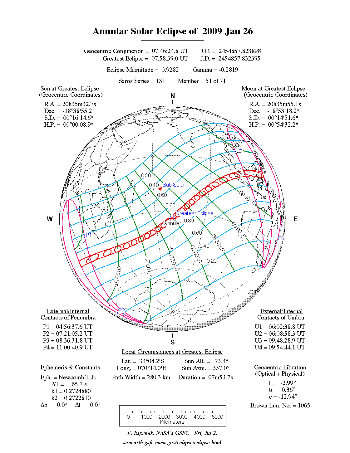
- 2009 Jan 26: Annular Solar Eclipse
- 2009 Feb 09: Penumbral Lunar Eclipse
- 2009 Jul 07: Penumbral Lunar Eclipse
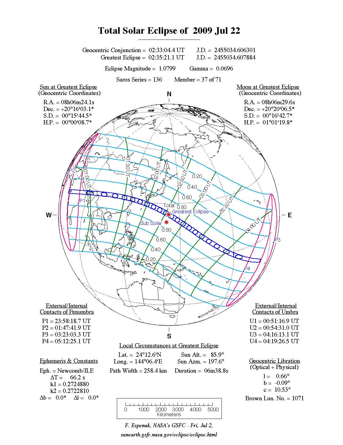
- 2009 Jul 22: Total Solar Eclipse
- 2009 Aug 06: Penumbral Lunar Eclipse
- 2009 Dec 31: Partial Lunar Eclipse
A full report on eclipses during 2009 will be published in Observer’s Handbook 2009.
NASA Solar Eclipse Bulletins
Special bulletins containing detailed predictions and meteorological data for future solar eclipses of interest are prepared by Fred Espenak and Jay Anderson and are published through NASA’s Publication series. The bulletins are provided as a public service to both the professional and lay communities, including educators and the media. A list of currently available bulletins and an order form can be found at:
http://eclipse.gsfc.nasa.gov/SEpubs/RPrequest.html
The most recent bulletin of the series covers the total solar eclipse of 2008 August 01 which is visible from northern Canada, Russia, Mongolia and China. Single copies of the eclipse bulletins are available at no cost by sending a 9 x 12-in. self-addressed envelope stamped with postage for 11 oz. (310 g). Please print the eclipse year on the envelope’s lower left corner. Use stamps only, since cash and cheques cannot be accepted. Requests from outside the United States and Canada may include 10 international postal coupons. Mail requests to: Fred Espenak, NASA's Goddard Space Flight Center, Code 693, Greenbelt MD 20771, USA.
The NASA eclipse bulletins are also available over the Internet, including out-of-print bulletins. Using a Web browser, they can be read or downloaded through the World Wide Web from the GSFC/SDAC (Solar Data Analysis Center) eclipse page:
Eclipse Web Sites
The URL of the NASA Eclipse Web Site is:
http://eclipse.gsfc.nasa.gov/eclipse.html
The site features predictions and maps for all solar and lunar eclipses well into the 21st century, with special emphasis on upcoming eclipses. Special pages are devoted to the total solar eclipses of 2008, 2009 and 2010 that feature detailed maps, tables, graphs, and meteorological data. A world atlas of solar eclipses provides maps of all central eclipse paths from 2000 BCE to 3000 CE. The entire Five Millenium Canon of Solar Eclipses [Espenak and Meeus, 2006] can be downloaded in PDF format and all maps are also available online as individual GIFs of PSFs. Additional catalogues list every solar and lunar eclipse over a 5000-year period.
Detailed information on solar and lunar eclipse photography and tips on eclipse observing and eye safety may be found at:
Acknowledgments
All eclipse predictions were generated on an Apple G4 iMac computer using algorithms developed from the Explanatory Supplement [1974] with additional algorithms from Meeus, Grosjean, and Vanderleen [1966]. The solar coordinates used in the eclipse predictions are based on VSOP87 [P. Bretagnon and G. Francou, 1988]. The lunar coordinates are based on ELP-2000/82 [M. Chapront-Touzé and J. Chapront, 1983]. For lunar eclipses, the diameter of the umbral and penumbral shadows were calculated using Danjon's rule of enlarging Earth's radius by 1/85 to compensate for the opacity of the terrestrial atmosphere; corrections for the effects of oblateness have also been included. Text and table composition was done on a Macintosh using Microsoft Word. Additional figure annotation was performed with Claris MacDraw Pro.
All calculations, diagrams, tables, and opinions presented in this paper are those of the author, and he assumes full responsibility for their accuracy.
Special thanks to National Space Club summer intern Sumit Dutta for his valuable assistance in preparing the web page (June 2007).
Footnotes
[1] The instant of greatest eclipse occurs when the distance between the Moon's shadow axis and Earth's geocentre reaches a minimum.
[2] Eclipse magnitude is defined as the fraction of the Sun's diameter occulted by the Moon
[3] The sub-solar point is the geographic location where the Sun appears directly overhead (zenith).
References
Bretagnon P., Francou G., "Planetary Theories in rectangular and spherical variables: VSOP87 solution", Astron. and Astrophys., vol. 202, no. 309 (1988).
Chapront-Touzé, M and Chapront, J., "The Lunar Ephemeris ELP 2000," Astron. and Astrophys., vol. 124, no. 1, pp 50-62 (1983).
Chauvenet, W., Manual of Spherical and Practical Astronomy, Vol.1, 1891 (Dover edition 1961).
Danjon, A., "Les éclipses de Lune par la pénombre en 1951," L'Astronomie, 65, 51-53 (Feb. 1951).
Espenak, F., Fifty Year Canon of Solar Eclipses: 1986–2035, Sky Publishing Corp., Cambridge, MA, 1988.
Espenak, F., Fifty Year Canon of Lunar Eclipses: 1986–2035, Sky Publishing Corp., Cambridge, MA, 1989.
Espenak, F., and Anderson, J., Total Solar Eclipse of 2008 August 01, NASA TP–2007-214149, Goddard Space Flight Center, Greenbelt, MD, 2007.
Espenak, F., and Meeus, J., Five Millennium Canon of Solar Eclipses: –2000 to +3000 (2000 BCE to 3000 CE), NASA TP–2006-214141, Goddard Space Flight Center, Greenbelt, MD, 2006.
Explanatory Supplement to the Astronomical Ephemeris and the American Ephemeris and Nautical Almanac, Her Majesty’s Nautical Almanac Office, London, 1974.
Littmann, M., Willcox, K., & Espenak, F., Totality—Eclipses of the Sun, Oxford University Press, New York, 1999.
Meeus, J., Grosjean, C.C., & Vanderleen, W., Canon of Solar Eclipses, Pergamon Press, New York, 1966.
Meeus, J. & Mucke, H., Canon of Lunar Eclipses: -2002 to +2526, Astronomisches Buro, Wien, 1979.
