
|
|---|
|
|
|---|

Between the Galápagos Islands and the South American continent, the shadow track moves across the ICZ and mean cloudiness increases to a maximum of 60%. Ordinarily this is one of the cloudiest areas of the globe, but the thunderstorm activity on the ICZ is very much subdued in February and dry weather is the rule rather than the exception. The influence of the ICZ extends onto the coast of Colombia, helping to create one of the world's wettest habitats, but the eclipse path fortunately skirts a little to the north of this sopping region. The mean cloud cover at the Panamanian coast is nearly the same as over the Galápagos.
Travel along the Panama-Columbia border is quite difficult. Heavy rains and a swampy landscape have conspired to foil completion of the Pan-American highway through this region, though atlases show a rudimentary road connection snaking from Panama City to the Colombian Pacific coast. Travel is likely best by boat to the vicinity of Jaqué, just north of the center line on the coast. Weather statistics for Jaqué are limited, but they show that mean rainfall is only 3 mm in February, compared to over 950 mm in October. The eclipse could not occur at a better time, as February is the driest month of the year here.
Winds in the Gulf of Panama have no preferred direction, but northeasterlies begin to dominate close to and over the Isthmus of Panama. This implies that Pacific coast sites may be drier and sunnier than those on the Caribbean side, as the air is flowing down the western side of the mountainous backbone of Panama. Air which is descending is drier than that which is flowing uphill. Wave heights are also relatively low here, as the variable winds and proximity of land limit the energy imparted to the ocean surface.
Past the Isthmus of Panama, the eclipse track crosses over the Golfo de Urabá, where Central and South America come together on the Caribbean coast, and then moves inland into Colombia. Though the Andes Mountains are greatly diminished in size at this point, the prevailing northerly upslope winds, and the nearby location of a weak ICZ combine to bring a region of slightly greater cloudiness and rainfall. Turbo, on the Golfo de Urabá, reports 6 hours of sunshine per day in February (Table 24). This region is the cloudiest land based site along the entire path.
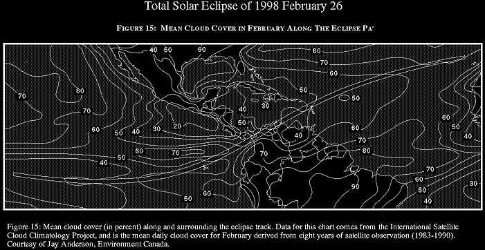
East of the Golfo de Urabá, the eclipse track crosses onto the Caribbean lowlands of Colombia. These lowlands lie between two branches of the Andes mountains which together provide some degree of protection from weather systems approaching from the northeast. Satellite measurements (Figure 15) show that cloud cover drops rapidly through this region, falling by nearly 20% from west to east across northern Colombia. Sunshine hours increase in a complementary fashion, rising from 6 hours per day at Turbo to 9 hours near Valledupar, close to the Venezuelan border. This is a very generous 80 percent of the maximum sunshine possible and eastern Colombia is an excellent location from which to observe the eclipse. Satellite measurements show less than 40% mean cloud cover here - as good as anywhere else along the path.
As the eclipse track leaves Colombia, it passes south of the 5775 m Sierra Nevada de Santa Maria. This mountain is an imposing peak, thrusting dramatically upward from sea level with a vertical rise which is comparable to the Himalayas. The eclipse track runs just south of the mountain; the north limit barely touches the summit. Just east of this solitary peak is the main branch of the Andes, the Sierra de Perijá which forms the border between Colombia and Venezuela. The valley between the Sierra Nevada and the Sierra de Perijá contains the city of Valledupar, a short distance north of the center line. The blocking effect of mountains to the east and west of the city serve to protect this segment of the track from errant weather systems which might bring cloud cover. In view of the excellent climatology, nearby track, and convenient road access, Valledupar provides a convenient base for an eclipse expedition.
Beyond Valledupar, the track climbs the Sierra de Perijá and moves into Venezuela and Lake Maracaibo. Good weather continues through the Maracaibo lowlands and out across the Gulf of Venezuela to Aruba and CuraŤao. This part of northern South America - across northern Colombia and northwest Venezuela, and continuing across the adjacent Caribbean - has an anomalously dry and sunny climate. The explanation for this semi-desert climate has eluded complete explanation, though it seems to be related to the deflection of the oceanic trade winds by the mountains along the north coast, and by the presence of a high pressure ridge extending from Bermuda. These two features cause the atmosphere to subside, drying and warming as it does, and suppressing the development of convective showers and thundershowers.
Whatever the explanation, eclipse observers will derive considerable benefit from this climatic bonus. And adding to this promising situation is the fact that in most locations along this part of the track, February is the driest or second driest month of the year, with as little as 1 mm of monthly rainfall recorded at one station (Uribia).
Still, northern South America is not completely without major winter weather systems. Rainfall statistics shows that there are uncommon instances of very heavy precipitation - more than 60 mm in 24 hours at Maracaibo for instance. These wet episodes are brought on by northern hemisphere disturbances which manage to reach low latitudes, either as cold fronts or as cold pools of air. The months of February and March are favored for such disturbances in Venezuela; in March they are known as the "invierno de las chicharras." The break in the normally dry weather is impressive, but the heaviest precipitation is reserved for the slopes of the coastal mountains where the air is forced to rise, adding to the processes which create rainfall. During such periods, cloud cover is widespread and solid, with depressing prospects for the eclipse chaser. Luckily they occur at intervals of several years - the rainfall record suggests about once every seven.
The largest city within the eclipse track is Maracaibo in Venezuela, solidly located within the best weather prospects. While the city lies south of the center line, the best spots on the track can be reached on the highway leading northward along the coast. The prevailing easterly winds off of the Gulf of Venezuela will stabilize the atmosphere and present a steadier view of the Sun, though the cooling which normally accompanies an oncoming eclipse will do this without further help.
Leaving the Maracaibo area, the track heads out across the Gulf of Venezuela, crossing onto land again on the narrow-necked Peninsula de Paraguaná. This is the last land-based location which gives access to the center line, though other island sites in the Caribbean offer excellent opportunities at a small cost in eclipse duration. For those watching from the Peninsula de Paraguaná, the refinery town of Punto Fijo would seem to be the best base, with a short trip northward required to reach the middle of the track. The eclipse duration at Punto Fijo is 3m 27s, only 20 seconds less than on the center line.

Adapted from NASA RP 1383 "Total Solar Eclipse of 1998 February 26".

WebMaster: Fred Espenak Planetary Systems Branch - Code 693 e-mail: espenak@lepvax.gsfc.nasa.gov NASA/Goddard Space Flight Center, Greenbelt, Maryland 20771 USA
|
|---|