Total Solar Eclipse of 2012 November 13
On 2012 November 13/14, a total eclipse of the Sun is visible from within a narrow corridor that traverses Earth's southern Hemisphere. The path of the Moon's umbral shadow begins in northern Australia and crosses the South Pacific Ocean with on other no landfall. The Moon's penumbral shadow produces a partial eclipse visible from a much larger region covering Australia, New Zealand, and the South Pacific.
For those traveling to Australia for the eclipse, please note that the eclipse occurs on the morning of Nov. 14 local time.
Although it was not possible to publish a NASA Eclipse Bullet for the 2012 total eclipse, this special web page contains much of the material that would have appeared in it.
Description of the 2012 Total Solar Eclipse
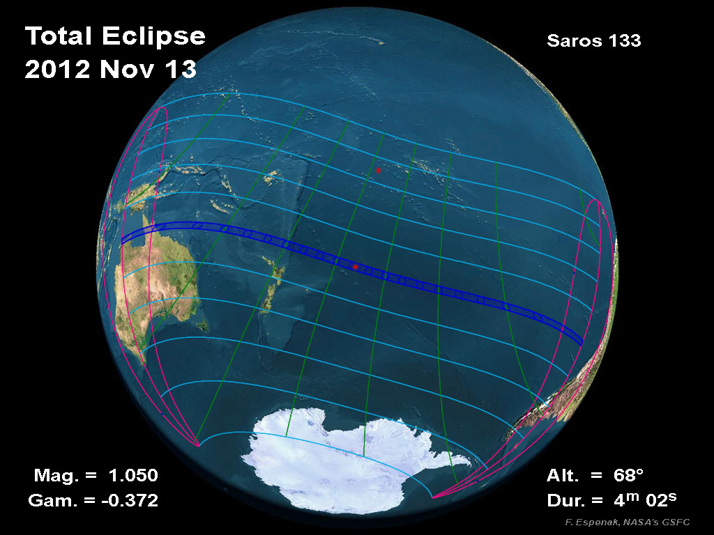
The total solar eclipse of 2012 occurs at the Moon's ascending node in central Libra. The path of the Moon's umbral shadow crosses the South Pacific Ocean where it makes no landfall except for northern Australia. The Moon's penumbral shadow produces a partial eclipse visible from a much larger region covering the South Pacific (including Australia and New Zealand), southern South America, and part of Antarctica (Figure 4).
The central eclipse path begins in Australia's Garig Ganak Barlu National Park in the Northern Territory about 250 kilometres east of Darwin at 20:35 UT (Figure 5). Traveling southeast, the umbral shadow quickly crosses the Gulf of Carpentaria and reaches the Cape York Peninsula at 20:37 UT.
The first and only populated region in the path lies along the east coast of Queensland. Gateway to Australia's Great Barrier Reef, Cairns is about 30 kilometres south of the central line. Its residents and visitors will enjoy an early morning total eclipse lasting 2 minutes with the Sun just 14° above the eastern horizon. Observers on the central line can eek out another 5 seconds of totality, but local weather conditions will play a far greater role in choosing a viewing site than a few seconds of totality.
After leaving Australia, the umbral shadow glides over the ocean, undisturbed by further landfall for the remainder of its track. The instant of greatest eclipse [1] occurs in the South Pacific at 22:11:48 UT. At this instant, the axis of the Moon's shadow passes closest to Earth's centre. The maximum duration of totality is 4 minutes 2 seconds, the Sun's altitude is 68°, and the path width is 179 kilometres. Continuing across the vast South Pacific, the umbral shadow's path ends about 800 kilometres west of Chile at 23:48 UT.
The NASA JavaScript Solar Eclipse Explorer is an interactive web page that can quickly calculate the local circumstances of the eclipse from any geographic location within the eclipse path:
eclipse.gsfc.nasa.gov/JSEX/JSEX-index.html
Over the course of 3.1 hours, the Moon's umbra travels along a path approximately 14,500 kilometres long covering 0.46% of Earth's surface area. Path coordinates and central line circumstances are presented in Table 3. All times are given in Universal Time. The Sun's altitude and azimuth, the eclipse magnitude [2] and obscuration [3] are all given at the instant of maximum eclipse.
This is the 45th eclipse of Saros 133 [4] (Espenak and Meeus, 2006). The series began on 1219 Jul 13 with the first of 13 partial eclipses. The first annular eclipse was non-central and occurred on 1435 Nov 20. Five more annular eclipses followed until a hybrid eclipse on 1544 Jan 24. Subsequent eclipses in the series have been total with a steadily increasing duration of totality until the peak duration of 6 minutes 50 seconds was reached on 1850 Aug 07. The duration of totality has been decreasing since then. The remaining 20 total eclipses will see totality drop to below 2 minutes. The series ends with a set of 7 partial eclipses the last of which occurs on 2499 Sep 05.
In all, Saros 133 produces 12 partial, 6 annular, 1 hybrid, 46 total, and 24 partial eclipses, in that order. Complete details for the series can be found at:
eclipse.gsfc.nasa.gov/SEsaros/SEsaros133.html
The above information is based on the article published in the RASC Observer's Handbook for 2012.
Footnotes
[1] The instant of greatest eclipse for solar eclipses occurs when the distance between the Moon's shadow axis and Earth's geocentre reaches a minimum.
[2] Eclipse magnitude for solar eclipses is defined as the fraction of the Sun's diameter occulted by the Moon.
[3] Eclipse obscuration is defined as the fraction of the Sun's area occulted by the Moon.
[4] The Saros is a period of 6,585.3 days (18 years 11 days 8 hours) in which eclipses (both solar and lunar) repeat. The geometry isn't exact but close enough for a Saros series to last 12 or more centuries.
Orthographic Map of the Total Solar Eclipse
The following map shows the overall regions of visibility of the partial eclipse as well as the path of the Total eclipse through Asia, the Pacific and North America. It uses high resolution coastline data from the World Data Base II (WDB).
Interactive Map of the Path of Totality
An implementation of Google Map has been created which includes the central path of the 2012 total solar eclipse. This allows the user to select any portion of the path and to zoom in using either map data or Earth satellite data.
Other interactive eclipse maps include those by Xavier Jubier and Bill Kramer.
Detailed Maps of the Path of Totality
Although a NASA eclipse bulletin was not published for this eclipse, Jay Anderson still generated a series of detailed eclipse maps.
Michael Zeiler (with the help of Bill Kramer and others) has produced an excellent set of maps for the total eclipse using the NASA Besselian elements. They are available via the following link.
Eclipse Elements, Shadow Contacts and Path of Totality
The following tables give detailed predictions including the Besselian Elements, shadow contacts with Earth, path of the umbral shadow and topocentric data (with path corrections) along the path.
- Table 1 - Elements of the Eclipse
- Table 2 - Shadow Contacts and Circumstances
- Table 3A - Path of the Umbral Shadow
- Table 3B - Path of the Umbral Shadow (Extended Version)
- Table 4A - Physical Ephemeris of the Umbral Shadow
- Table 4B - Physical Ephemeris of the Umbral Shadow (Extended Version)
- Table 5 - Local Circumstances on the Central Line
- Table 6 - Topocentric Data and Path Corrections Due to Lunar Limb Profile
Coordinate Tables for the Path of Totality
The following tables provide detailed coordinates for the path of the antumbral shadow as well as the zones of grazing eclipse. They are listed in a format convenient for plotting on maps.
- Table 7A - Mapping Coordinates for the Umbral Path
- Table 7B - Mapping Coordinates for the Umbral Path (Australia; Extended - 15´ step size)
- Table 8A - Mapping Coordinates for the Zones of Grazing Eclipse
- Table 8B - Mapping Coordinates for the Zones of Grazing Eclipse (Australia; Extended - 15´ step size)
Local Circumstances
The following table gives the local circumstances of the eclipse from various cities throughout the Southern Hemisphere. All contact times are given in the tables are in Universal Time.
- Local Circumstances for Australia, New Zealand and Pacific
- Local Circumstances for South America and Antarctica
Limb Profile
The following figure shows the lunar limb profile at 20:39 UT (i.e., as seen from the central path in Queensland, Australia). See Lunar Limb Profile for an explanation of this figure.
Sky During Totality
The following figure shows the sky during totality at 20:39 UT (i.e., as seen from the eclipse path in Queensland, Australia).
The brightest planet visible during the total eclipse is Venus (mv=-3.7) located 32° west of the Sun. Although Mercury (mv=+3.2) is only 9° east of the Sun, it will be quite faint. Saturn (mv=+1.2) will also be difficult to spot 17° west of the Sun. Bright stars, which might also be visible, include Procyon (mv=+0.38), Sirius (mv=-1.44), Arcturus (mv=-0.04), Spica (mv=+1.04) and Canopus (mv=-0.72).
Explanation of Eclipse Maps, Figures and Tables
The following links give detailed descriptions and explanations of the eclipse maps and tables.
- Map 1 - Orthographic Map of the Eclipse Path
- Table 1 - Elements of the Eclipse
- Table 2 - Shadow Contacts and Circumstances
- Table 3 - Path of the Umbral (or Antumbral) Shadow
- Table 4 - Physical Ephemeris of the Umbral (or Antumbral) Shadow
- Table 5 - Local Circumstances on the Central Line
- Table 6 - Topocentric Data and Path Corrections Due to Lunar Limb Profile
- Table 7A & 7B - Mapping Coordinates for the Central Path
- Table 8A & 8B - Coordinates for the Zones of Grazing Eclipse
- Mean Lunar Radius
- Lunar Limb Profile
- Limb Corrections to the Path Limits: Graze Zones
Weather
Eclipse Photography
Reproduction of Eclipse Data
All eclipse calculations are by Fred Espenak, and he assumes full responsibility for their accuracy. Permission is freely granted to reproduce this data when accompanied by an acknowledgment:
"Eclipse Predictions by Fred Espenak, NASA's GSFC"
For more information, see: NASA Copyright Information
More information on this eclipse can be found in the Observer's Handbook for 2012.
