The following table delineates the path of the Moon's antumbral shadow during the Annular Solar Eclipse of 2003 May 31. The geographic coordinates (WGS 84) of the northern and southern limits and the central line are listed at 120-second intervals. This provides adequate detail for making plots of the path on larger scale maps. Local circumstances on the central line include the ratio of the apparent diameters of the Moon to the Sun, the Sun's altitude and azimuth (degrees), the path width (kilometers) and the duration on the central line (minutes and seconds).
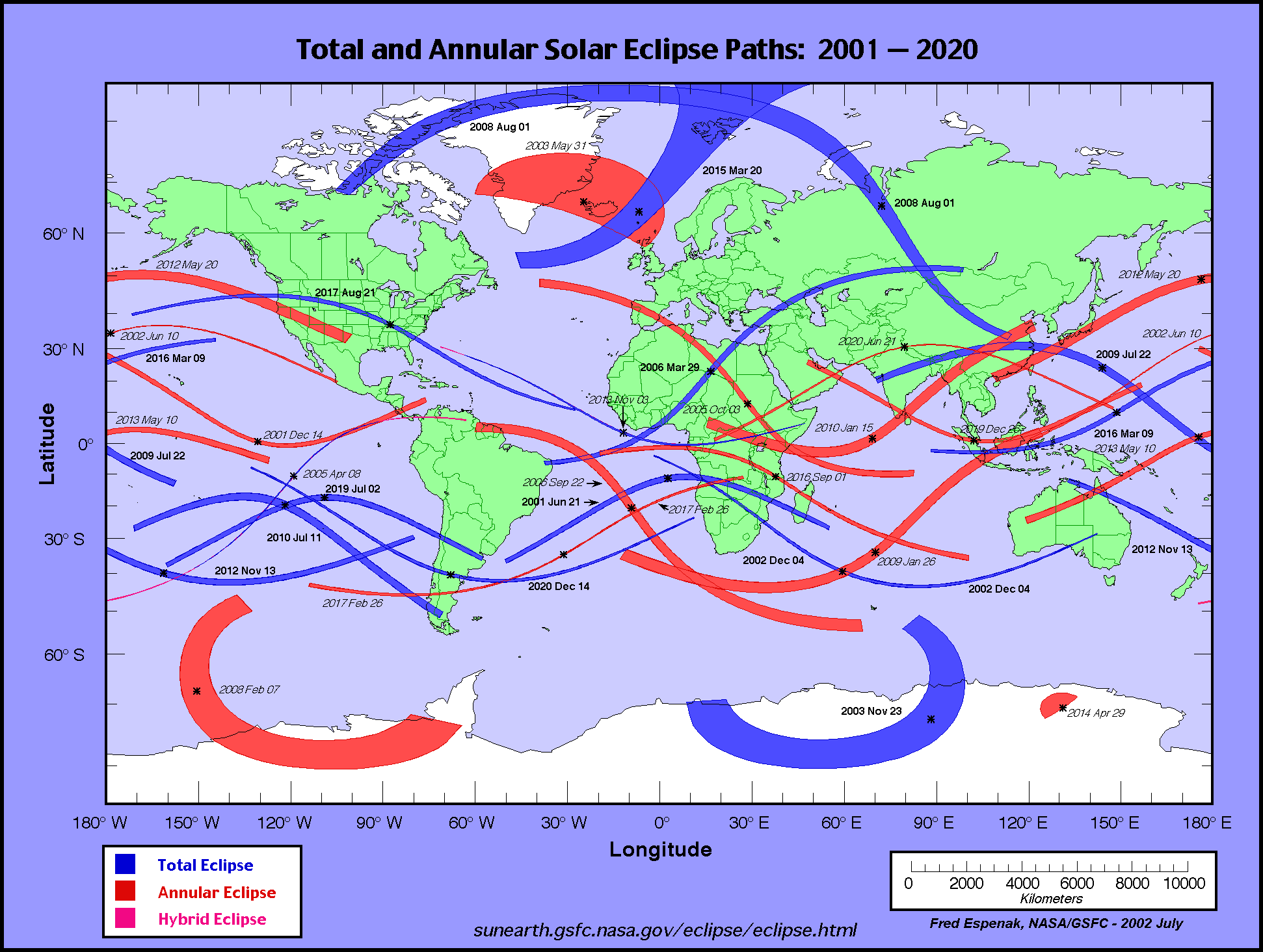
The global visibility of the eclipse is shown on an Orthographic Map . The features of this map are described in the Key to Solar Eclipse Path Tables. The path of the eclipse is displayed in greater detail on an Google Map .
                                                                      M:S                 Central
Universal  Northern Limit      Southern Limit       Central Line     Diam.  Sun Sun Path   Line
         ------------------  ------------------  ------------------  Ratio  Alt Azm Width Durat.
  Time   Latitude Longitude  Latitude Longitude  Latitude Longitude
          °   ´     °   ´      °   ´     °   ´      °   ´     °   ´            °   °   km

 Limits  56 47.3N 004 35.9W  56 47.3N 004 35.9W  62 25.2N 021 16.5W  0.000   0   -    0  00m00.0s
 03:46   57 10.4N 005 31.8W  59 15.9N 001 01.4W     -         -        -      -   -    -    -
 03:48   57 52.8N 007 17.8W  61 23.4N 000 45.3E     -         -        -      -   -    -    -
 03:50   58 34.4N 009 06.7W  63 00.9N 001 27.9E     -         -        -      -   -    -    -
 03:52   59 15.0N 010 58.5W  64 25.3N 001 38.8E     -         -        -      -   -    -    -
 03:54   59 54.7N 012 53.6W  65 41.6N 001 27.0E     -         -        -      -   -    -    -
 03:56   60 33.5N 014 52.0W  66 52.1N 000 56.3E     -         -        -      -   -    -    -
 03:58   61 11.1N 016 53.8W  67 58.0N 000 08.0E     -         -        -      -   -    -    -
 04:00   61 47.7N 018 59.2W  68 59.9N 000 57.4W     -         -        -      -   -    -    -

 04:02   62 23.1N 021 08.4W  69 58.0N 002 20.5W     -         -        -      -   -    -    -
 04:04   62 57.2N 023 21.4W  70 52.6N 004 02.0W  64 39.7N 020 30.6W  0.938   2  38 5201  03m36.4s
 04:06   63 30.1N 025 38.4W  71 43.4N 006 03.3W  65 44.1N 021 58.5W  0.938   3  37 4871  03m36.7s
 04:08   64 01.5N 027 59.4W  72 30.2N 008 25.7W  66 27.6N 024 08.2W  0.938   3  35 4678  03m36.8s
 04:10   64 31.5N 030 24.6W  73 12.6N 011 10.7W  66 53.4N 026 52.0W  0.938   3  33 4648  03m36.7s
 04:12   64 59.9N 032 54.0W  73 49.9N 014 19.8W  66 56.9N 030 11.7W  0.938   2  31 4825  03m36.4s
 04:14   65 26.7N 035 27.6W  74 21.3N 017 53.7W  66 01.6N 034 44.9W  0.938   1  27 5435  03m35.5s
 04:16   65 51.8N 038 05.4W  74 45.8N 021 52.8W     -         -        -      -   -    -    -
 04:18   66 15.1N 040 47.3W  75 02.1N 026 15.8W     -         -        -      -   -    -    -
 04:20   66 36.4N 043 33.2W  75 08.7N 031 00.0W     -         -        -      -   -    -    -

 04:22   66 55.7N 046 23.1W  75 03.7N 036 00.9W     -         -        -      -   -    -    -
 04:24   67 13.0N 049 16.6W  74 44.5N 041 12.1W     -         -        -      -   -    -    -
 04:26   67 28.1N 052 13.6W  74 07.6N 046 26.3W     -         -        -      -   -    -    -
 04:28   67 40.9N 055 13.6W  73 05.7N 051 35.9W     -         -        -      -   -    -    -
 04:30   67 51.4N 058 16.4W  71 18.3N 056 37.0W     -         -        -      -   -    -    -

 Limits  67 57.0N 060 19.3W  67 57.0N 060 19.3W  65 28.7N 035 39.4W  0.000   0   -    0  00m00.0s
   Instant of
Greatest Eclipse:       Time =  04:08:18.0 UT       Lat = 66°32.7'N      Long = 024°30.7'W
      (GE)               Sun Altitude =   2.9°          Path Width =4663.1 km
                          Sun Azimuth =  35.1°    Central Duration =   03m36.8s


   Instant of
Greatest Duration:      Time =    04:07:54 UT       Lat =   66°26'N      Long =   024°01'W
      (GD)               Sun Altitude =   2.9°          Path Width =4684.2 km
                          Sun Azimuth =  35.4°    Central Duration =   03m36.8s
Predictions for the Annular Solar Eclipse of 2003 May 31 were generated using the VSOP87/ELP2000-85 solar and lunar ephemerides and a value of ΔT = 64.5 seconds.
The eclipse predictions presented here DO NOT include the effects of mountains and valleys along the edge of the Moon. Such corrections for the lunar limb profile may shift the limits of the eclipse path north or south by ~1-3 kilometers, and change the eclipse duration by ~1-3 seconds. More detailed predictions including the effects of the lunar limb profile are normally posted 12-18 months before each eclipse,
All eclipse calculations are by Fred Espenak, and he assumes full responsibility for their accuracy. Permission is freely granted to reproduce this data when accompanied by an acknowledgment:
"Eclipse Predictions by Fred Espenak, NASA's GSFC"
For more information, see: NASA Copyright Information
