
|
|
|---|
![]()
To Be Published in Observer's Handbook 2001, Royal Astronomical Society of Canada
![]()
During the year 2001, Two solar and three lunar eclipses occur as follows:
2001 Jan 09: Total Lunar Eclipse
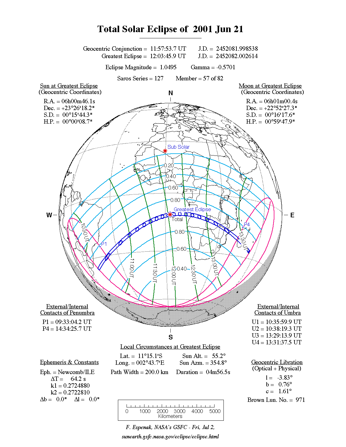
2001 Jun 21: Total Solar Eclipse
2001 Jul 05: Partial Lunar Eclipse
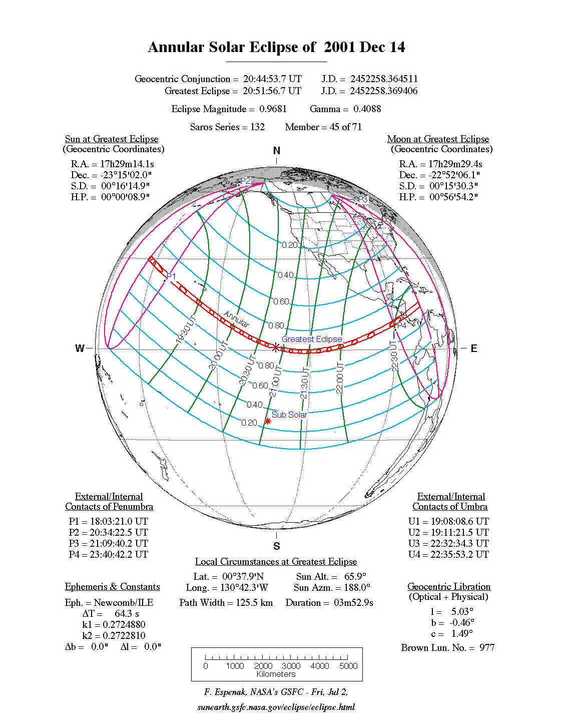
2001 Dec 14: Annular Solar Eclipse
2001 Dec 30: Penumbral Lunar Eclipse
Predictions and maps for the solar and lunar eclipses are presented in a number of figures linked to this document. World maps show the regions of visibility for each eclipse. The lunar eclipse diagrams also include the path of the Moon through Earth's shadows. Contact times for each principal phase are tabulated along with the magnitudes and geocentric coordinates of the Sun and Moon at greatest eclipse.
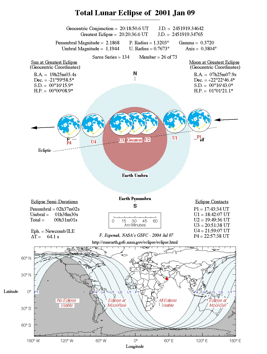
2001 Jan 09: Total Lunar Eclipse
                        Penumbral Eclipse Begins:  17:43:28 UT
                        Partial Eclipse Begins:    18:42:00 UT
                        Total Eclipse Begins:      19:49:29 UT
                        Greatest Eclipse:          20:20:30 UT
                        Total Eclipse Ends:        20:51:31 UT
                        Partial Eclipse Ends:      21:59:01 UT
                        Penumbral Eclipse Ends:    22:57:31 UT
The first lunar eclipse of the year is total and is well placed for Eastern Hemisphere observers. Nevertheless, the total phase can be seen from the northeastern most Canada. The event occurs just half a day before perigee. The Moon is in Gemini about one degree west of the bright star Delta Gem (m = +3.53).
Although the eclipse is not central (the Moon passes north of the shadow axis), the total phase still lasts 62 minutes. The eclipse begins at 17:43.6 UT with first penumbral contact. An hour later, the partial eclipse commences with first umbral contact at 18:42.1 UT. The total umbral eclipse begins at 19:49.6 UT and ends at 20:51.7 UT. The partial phase ends at 21:59.1 UT and the Moon leaves the penumbral shadow at 22:57.7 UT. The Moon's path through Earth's shadows as well as a map showing worldwide visibility of the event is shown in Figure 1.
At the instant of mid-eclipse (20:20.6 UT), the Moon will lie in the zenith for observers in Saudi Arabia. At this time, the umbral magnitude peaks at 1.1947 as the Moon's southern limb passes 6.1 arc-minutes north of the shadow's axis. In contrast, the Moon's northern limb will lie 6.5 arc-minutes from the northern edge of the umbra and 39.5 arc-minutes from the shadow centre. Thus, the northern sections of the Moon will appear much brighter than the southern part that will lie deeper in the shadow. Since the Moon samples a large range of umbral depths during totality, its appearance will likely change dramatically with time. However, it's impossible to predict the exact brightness distribution in the umbra so observers are encouraged to estimate the Danjon value at different times during totality (see: Danjon Scale of Lunar Eclipse Brightness). Note that it may also be necessary to assign different Danjon values to different portions of the Moon (i.e. - north vs. south).
During totality, the winter Milky Way and constellations will be well placed for viewing. Castor and Pollux lie 8-10 degrees north of the eclipsed Moon, while the Beehive cluster (M44) in Cancer is 17° to the east. Jupiter, Saturn and the Pleiades form an attractive trio in Taurus, about fifty degrees west of the Moon.
The event will be widely visible from Europe, Africa and Asia. The Moon sets in Australia during various stages of the eclipse. Observers in eastern Canada (Maritime Provinces) will find the totality already in progress at moonrise. Ontario, Quebec and New England (U.S.) will witness the final partial phases as the moon rises.
Table 1 lists predicted umbral immersion and emersion times for twenty well-defined lunar craters. The timing of craters is useful in determining the atmospheric enlargement of Earth's shadow (see: Crater Timings During Lunar Eclipses).
The first total solar eclipse of the Third Millennium will be visible from within a narrow corridor that traverses the Southern Hemisphere. The path of the Moon's umbral shadow begins in the South Atlantic, crosses southern Africa and Madagascar, and ends at sunset in the Indian Ocean. A partial eclipse will be seen within the much broader path of the Moon's penumbral shadow, which includes eastern South America and the southern two thirds of Africa (Figure 2).
The eclipse begins in the South Atlantic about 400 kilometres southeast of Uruguay. The Moon's umbral shadow first touches down on Earth at 10:35:55 UT. Along the sunrise terminator, the duration is 2m 6s as seen from the centre of the 127 kilometres wide path. During the next two hours, the umbra sweeps across the South Atlantic with no major landfall. The central duration, path width and Sun's altitude all steadily increase as the Moon's shadow rushes along its northeastern transoceanic course.
The instant of greatest eclipse occurs at 12:03:41 UT when the axis of the Moon's shadow passes closest to the centre of Earth (gamma = -0.570). The length of totality reaches its maximum duration of 4m 56s, the Sun's altitude is 55°, the path width is 200 kilometres and the umbra's velocity is 0.554 km/s. Unfortunately, these most favorable circumstances occur at sea some 1100 kilometres west of equatorial Africa's South Atlantic coastline (Figure 3).
Another half-hour will elapse before the umbra reaches southern Africa. During this period, the duration and path width will slowly wane as the curvature of Earth carries the projected eclipse path away from the Moon. As a result, the tapering shadow cone will present a progressively narrower cross section to Earth's surface along the path of totality. Nevertheless, the 2001 total solar eclipse is over twice as long as the last total eclipse in 1999 at all corresponding positions along the path. Landfall finally occurs along the Atlantic coast of Angola at 12:36 UT. The centreline duration is 4m 36s, the path width is 193 kilometres and the Sun's altitude is 49°. Traveling with a ground speed of 0.63 km/s, the umbra swiftly moves eastward through the civil war torn nation. Although the weather prospects are excellent, Angola's political strife makes it a dangerous place for eclipse observers. By 12:57 UT, the shadow reaches the western border of Zambia where totality lasts a maximum of 4m 06s. The umbra's path is now directed to the east-southeast as it heads towards the nation's capital city. Lying about 40 km south of the centreline, Lusaka enjoys a total eclipse lasting a respectable 3m 14s. Further to the north, the centre line duration is 3m 35s and the Sun's altitude is 31°. Quickly crossing the Zambezi River, the path continues into Zimbabwe and Mozambique. The centreline runs near the border between these two nations for several hundred kilometres. Zimbabwe's capital city of Harare lies just 100 km south of the path, so its citizens will witness a partial eclipse of magnitude 0.976. As the umbra leaves Zimbabwe, it lies wholly within Mozambique for a minute before its leading edge reaches the shore of the Indian Ocean (~13:20 UT). At nearly the same time, its northern edge just skirts the southern border of Malawi. The centreline duration is now 3m 09s as the Sun's altitude drops to 23°. The shadow's speed has increased to 1.7 km/s as it begins to leave the continent for the open waters of the Indian Ocean.
One last major landfall remains as the umbra races over southern Madagascar. The eclipse occurs quite late in the day with the Sun just 11° above the western horizon. The central duration now stands at 2m 25s (13:28 UT) as the shadow's long elliptical projection stretches across the entire east-west breadth of the island. Continuing into the Indian Ocean, the umbra leaves Earth's surface (13:31:33 UT) as the path ends. Over the course of 2 hours and 54 minutes, the Moon's umbra travels along a path approximately 12,000 kilometres long and covering 0.3% of Earth's surface area. Path coordinates and centreline circumstances are presented in Table 2.
Local circumstances for cities throughout the path are given in Table 3. All times are given in Universal Time. The Sun's altitude and azimuth, the eclipse magnitude and obscuration are all given at the instant of maximum eclipse. The appearance of the eclipse at maximum phase for a number of locations is depicted in What Will The Eclipse Look Like? An 88 page detailed report on this eclipse is available from NASA as Technical Publication 1999-209484 (see: NASA Solar Eclipse Bulletins). Additional information is also available at the 2001 total solar eclipse web site:
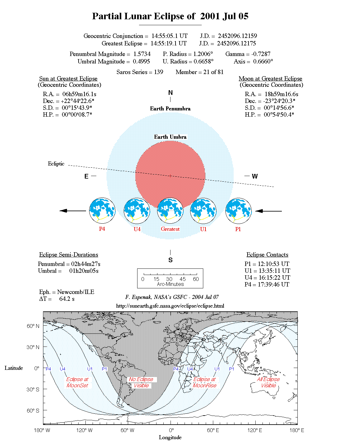
2001 Jul 05: Partial Lunar Eclipse
                        Penumbral Eclipse Begins:  12:10:46 UT
                        Partial Eclipse Begins:    13:35:04 UT
                        Greatest Eclipse:          14:55:12 UT
                        Partial Eclipse Ends:      16:15:15 UT
                        Penumbral Eclipse Ends:    17:39:40 UT
The second lunar eclipse of the year is partial and occurs in eastern Sagittarius three degrees north of Nunki (Sigma Sag). The event is a moderate partial eclipse with the Moon's northern limb dipping 15 arc-minutes into Earth's umbral shadow. The penumbral phase begins at 12:10.9 UT, but most observers will be unable to detect any shading during the first half hour or so. The partial eclipse commences with first umbral contact at 13:35.2 UT. Two hours and forty minutes later, the partial eclipse ends at 16:15.3 UT. Although it can not actually be observed, the eclipse technically ends when the Moon leaves the penumbral shadow at 17:39.8 UT.
At the instant of mid-eclipse (14:55.3 UT), the Moon will stand at the zenith for observers in central Australia. At that time, the umbral eclipse magnitude peaks at 0.4992 as the centre of the Moon passes along the southern edge of the umbra. Unfortunately, none of the partial phases will be visible from North America except from the Aleutian Islands. The eclipse is best seen from the western Pacific, Asia and Australia. The Moon's path through Earth's shadow(s) as well as a map showing worldwide visibility of the event is shown in Figure 4.
Table 4 lists predicted umbral immersion and emersion times for fifteen bright lunar craters. The timing of craters is useful in determining the atmospheric enlargement of Earth's shadow (see section: Crater Timings During Lunar Eclipses).
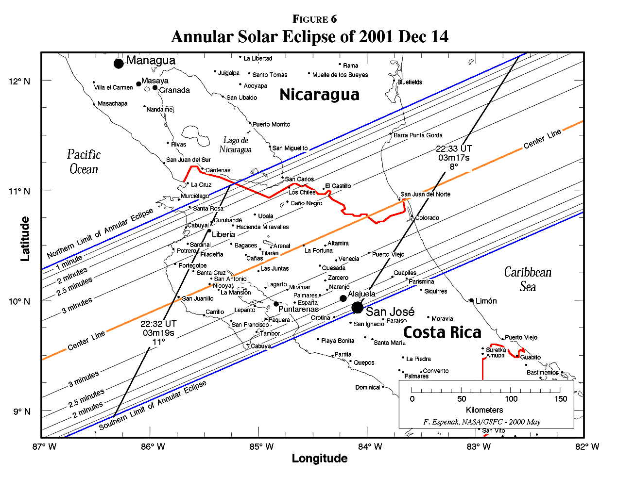
The last solar eclipse of 2001 is an annular eclipse visible primarily from the western hemisphere (Figure 5). The Moon's antumbral shadow first touches down on Earth at 19:08 UT near the International Date Line some 3000 kilometres northwest of the Hawaiian Islands. Unfortunately, the path of annularity misses the island chain and passes about 500 km to its south. Still, the islands enjoy a deep partial eclipse with a magnitude exceeding 0.8.
Traveling along a southeastern track, the path begins curving northward as it reaches the Equator. Greatest eclipse occurs at 20:51:56 UT just half a degree north of the Equator. The duration of the annular phase will last for 3m53s, but the event takes place in open ocean with no landfall in sight.
As the path swings to the northeast, it finally makes its only major landfall as it quickly crosses the Central American nations of Costa Rica and Nicaragua. Figure 6 is a detailed map showing the path limits, centreline and curves of constant duration through these countries. Mid-annularity occurs along the Pacific coast of Costa Rica at 22:32 UT during the late afternoon. The Sun will stand 11° above the southwestern horizon during an annular phase lasting 3m19s. The corresponding eclipse magnitude and obscuration (fraction of Sun's surface) will be 0.956 and 0.915, respectively. Costa Rica's capital city of San Jose actually lies just inside the southern limit where mid-annularity occurs at 23:33 UT.
Several minutes later, the antumbral shadow leaves Earth's surface at 22:35:53 UT. Over the course of 3 hours and 28 minutes, the Moon's antumbra travels along a path approximately 12,900 kilometres long and covering 0.4% of Earth's surface area. Path coordinates and centreline circumstances are presented in Table 5.
Partial phases of the eclipse are visible from much of North America as well as northwestern South America. Local circumstances for a number of cities are listed in Table 6. All times are given in Universal Time. The Sun's altitude and azimuth, the eclipse magnitude and obscuration are all given at the instant of maximum eclipse.
The appearance of the eclipse at maximum phase for a number of locations is depicted in What Will The Eclipse Look Like? Additional information is also available at the 2001 annular solar eclipse web site:
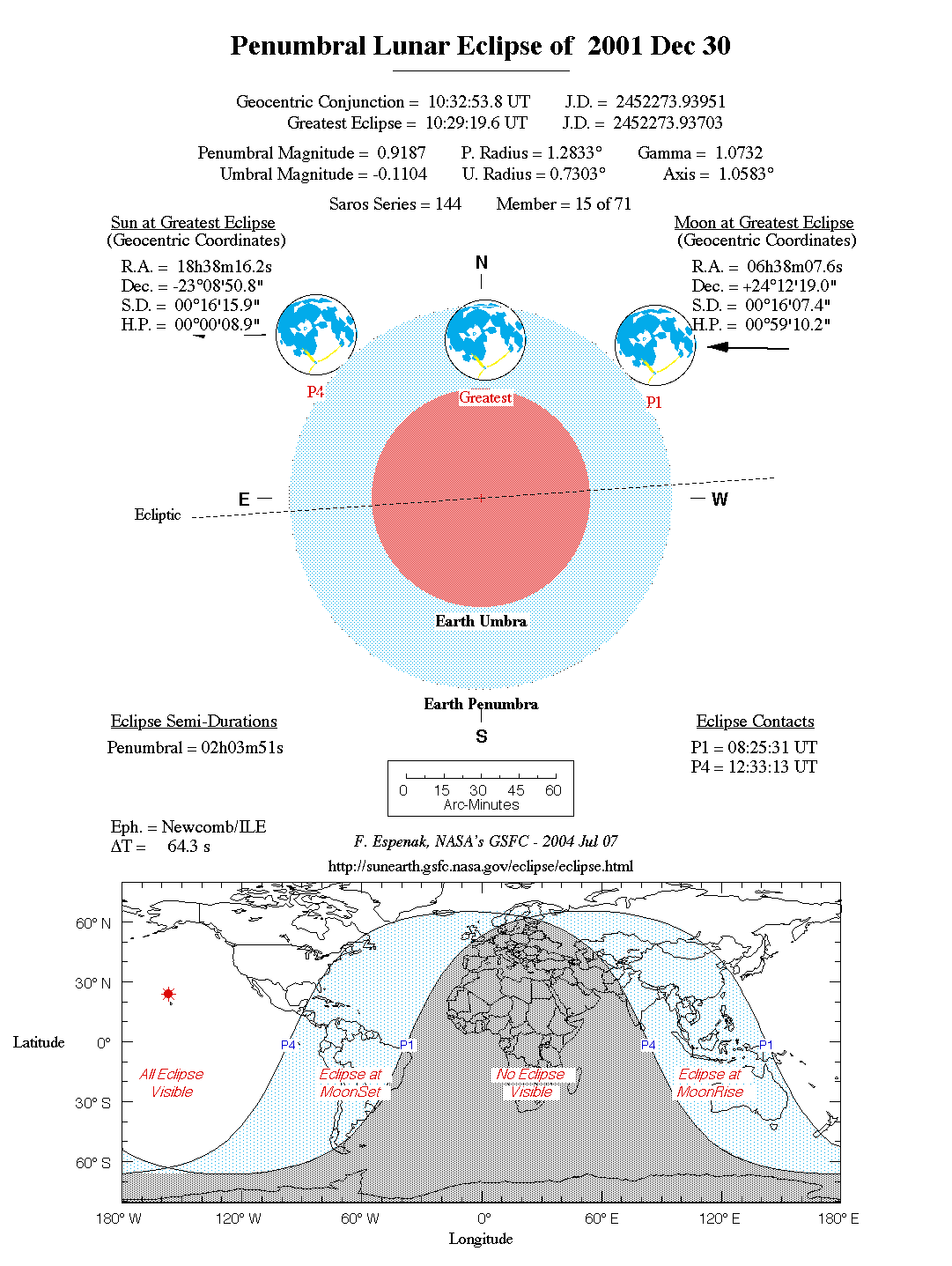
2001 Dec 30: Penumbral Lunar Eclipse
                        Penumbral Eclipse Begins:  08:25:24 UT
                        Greatest Eclipse:          10:29:12 UT
                        Penumbral Eclipse Ends:    12:33:06 UT
The final event of the year is a deep penumbral lunar eclipse visible from much of the Western Hemisphere. First and last penumbral contacts occur at 08:25.5 UT and 12:33.2 UT, respectively.
Greatest eclipse occurs at 10:29.3 UT with a maximum penumbral eclipse magnitude of 0.9190. Observers will note subtle yet distinct shading across the southern portions of the Moon. The Moon's southern limb actually lies 3.5 arc-minutes north of the umbra at its closest approach.
The Moon's path through Earth's penumbra as well as a map showing worldwide visibility of the event is shown in Figure 7.
             h  = 15 (GST + UT - ra ) + l
             a  =  ArcSin  [ Sin d Sin f + Cos d Cos h Cos f ]
             A  =  ArcTan  [ - (Cos d Sin h) / (Sin d Cos f -  Cos d Cos h Sin f) ]

     where:
             h  =  Hour Angle of Sun or Moon
             a  =  Altitude
             A  =  Azimuth
           GST  =  Greenwich Sidereal Time at 0:00 UT
            UT  =  Universal Time
            ra  =  Right Ascension of Sun or Moon
             d  =  Declination of Sun or Moon
             l  =  Observer's Longitude (East +, West -)
             f  =  Observer's Latitude (North +, South -)
During the eclipses of 2001, the values for GST and the geocentric Right Ascension and Declination of the Sun or the Moon (at greatest eclipse) are as follows:
      Eclipse               Date           GST         ra         d

     Total Lunar         2001 Jan 09       7.296      7.419     22.380
     Total Solar         2001 Jun 21      17.984      6.013     23.438
     Partial Lunar       2001 Jul 05      18.911     18.988    -23.406
     Annular Solar       2001 Dec 14       5.573     17.487    -23.251
     Penumbral Lunar     2001 Dec 30       6.596      6.635     24.205
2002 May 26: Penumbral Lunar Eclipse
2002 Jun 10: Annular Solar Eclipse
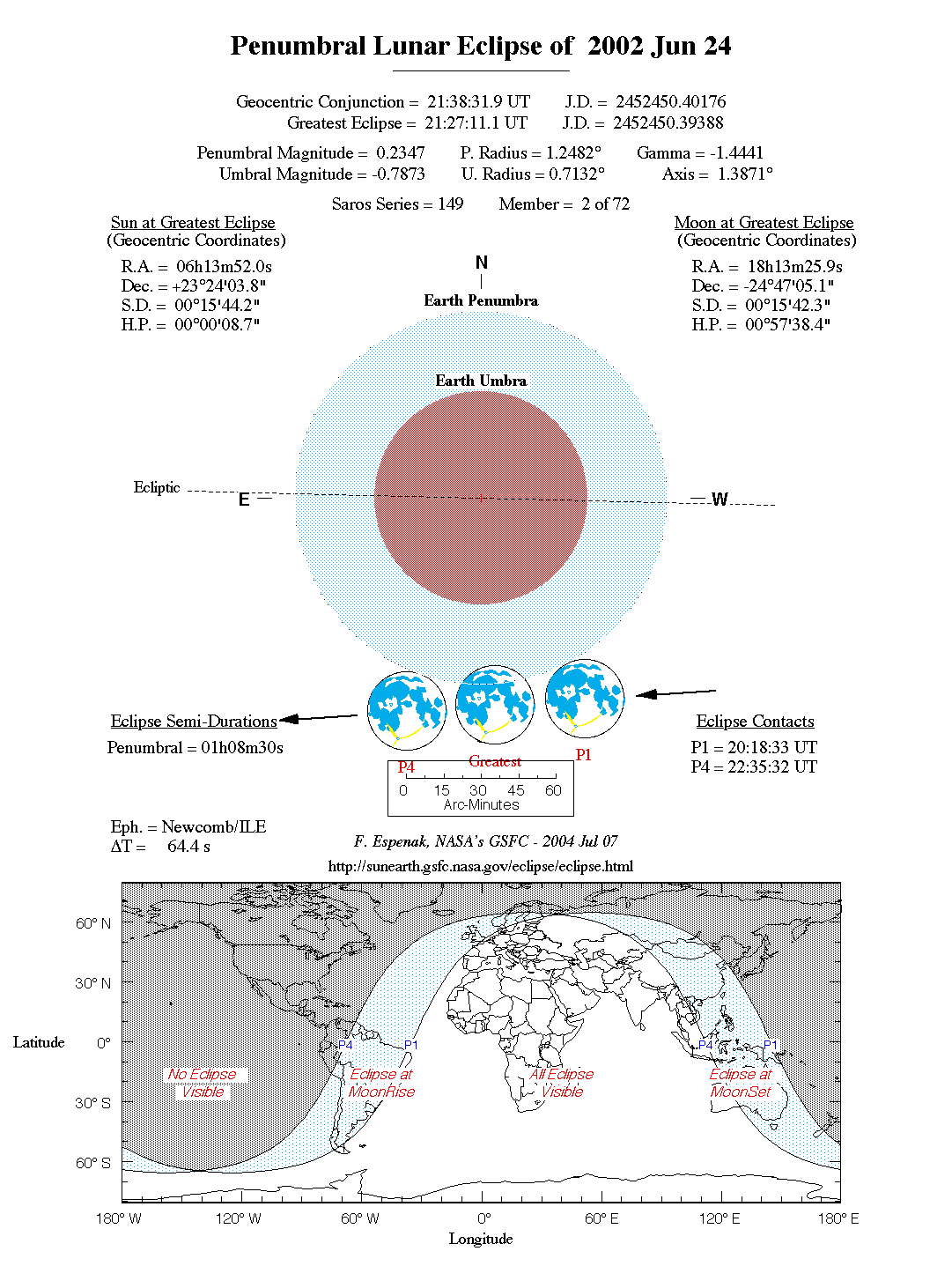
2002 Jun 24: Penumbral Lunar Eclipse
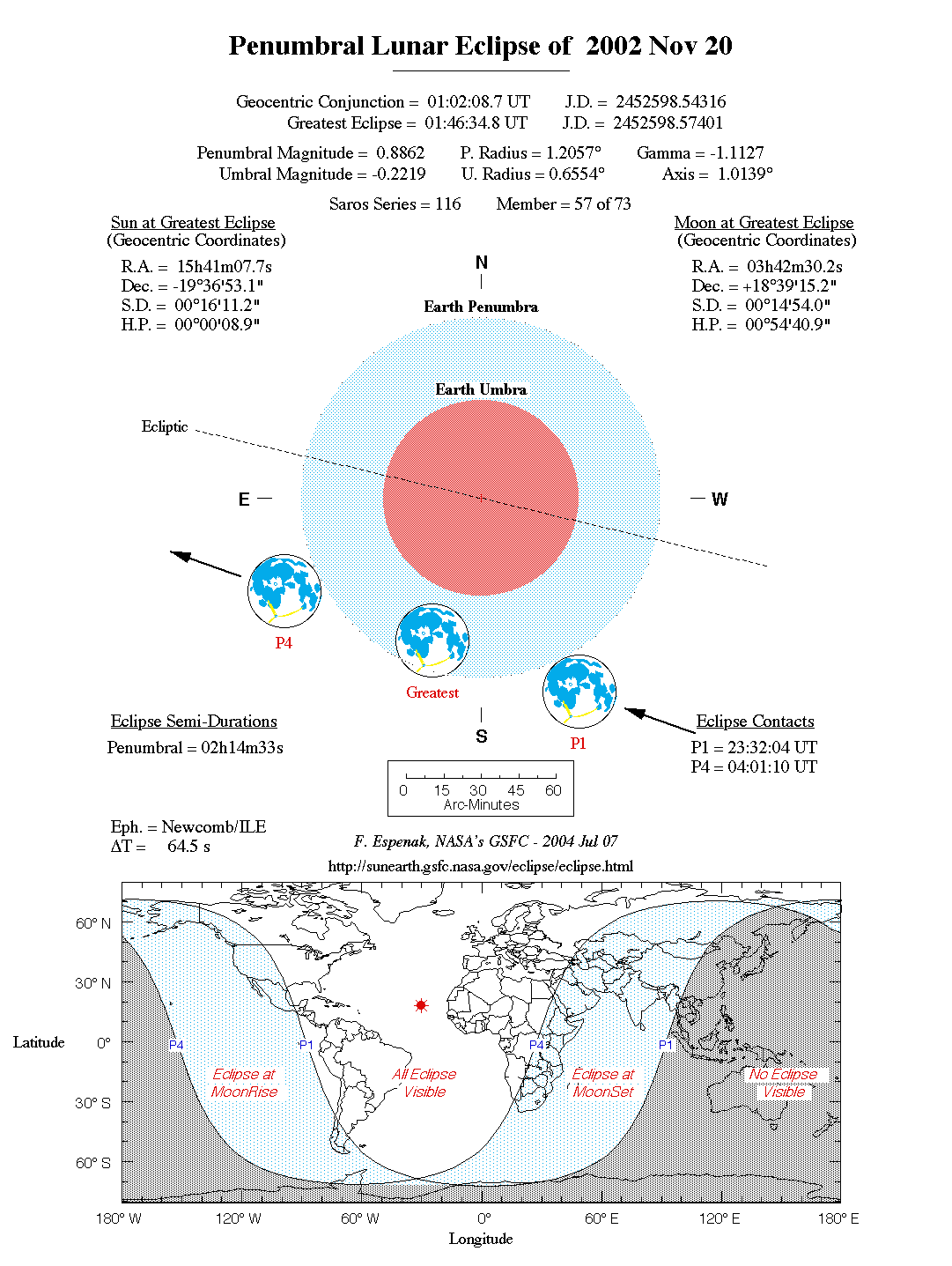
2002 Nov 20: Penumbral Lunar Eclipse
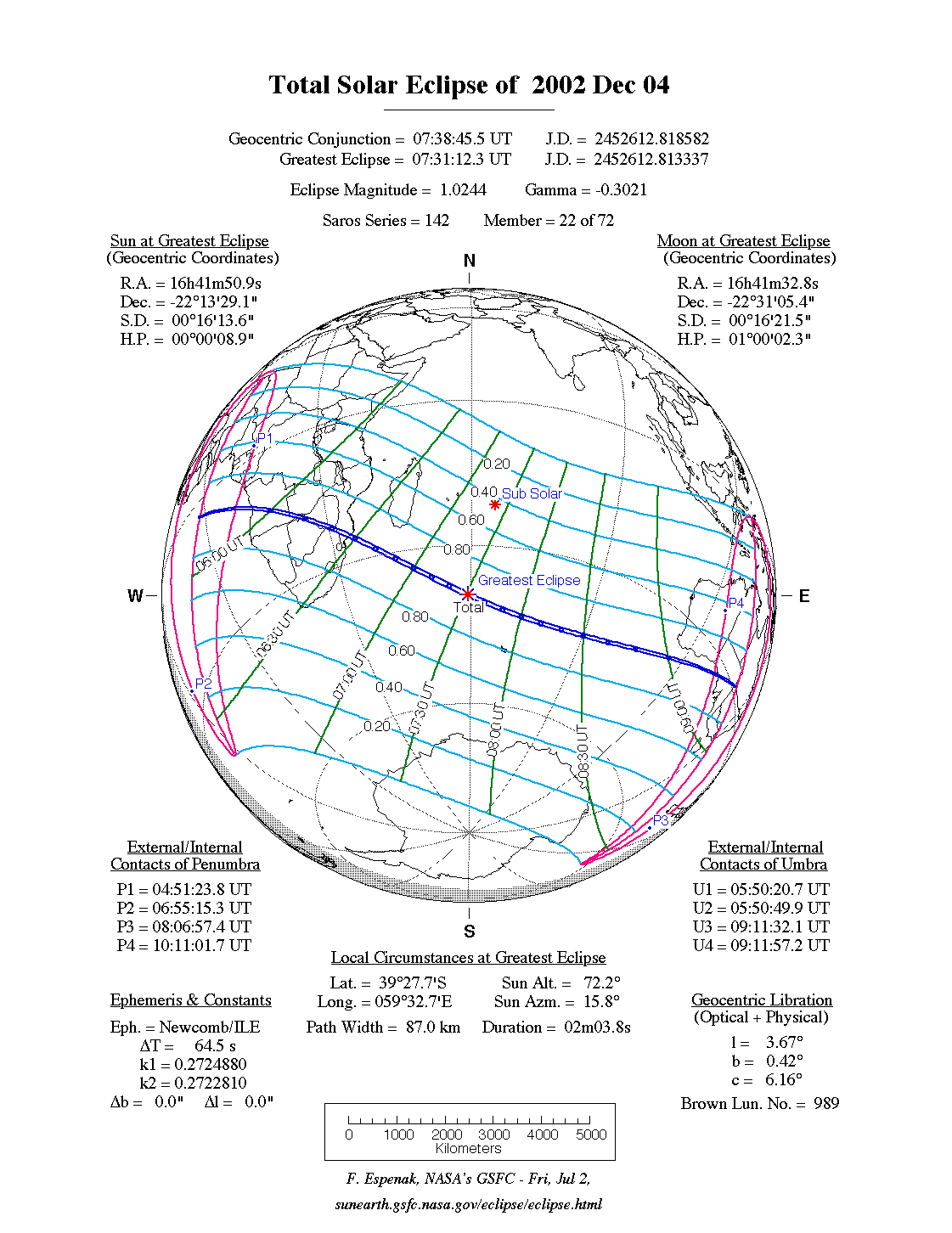
2002 Dec 04: Total Solar Eclipse A full report Eclipses During 2002 will be published next year in the Observer's Handbook 2002.
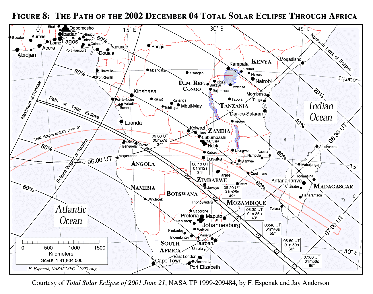
The next total eclipse of the Sun is also visible from southern Africa. The path of the Moon's umbral shadow begins in the South Atlantic, off the west coast of equatorial Africa. It crosses through Angola, Zambia, Namibia, Botswana, Zimbabwe, South Africa and Mozambique (Figure 8). Totality takes place in the morning hours with a central duration ranging from 1 to 1.5 minutes. The track continues across the Indian Ocean and ends in southern Australia north of Adelaide.
Complete details will eventually be posted on the NASA TSE2002 web site as well as in the next NASA bulletin scheduled for publication in late 2000. The TSE2002 web site address is:
Special bulletins containing detailed predictions and meteorological data for future solar eclipses of interest are prepared by F. Espenak and J. Anderson, and are published through NASA's Publication series. The bulletins are provided as a public service to both the professional and lay communities, including educators and the media. A list of currently available bulletins and an order form can be found at:
Single copies of the eclipse bulletins are available at no cost by sending a 9 by 12 inch self-addressed envelope stamped with postage for 11 ounces (310 grams. Please print the eclipse year on the envelope's lower left corner. Use stamps only, since cash or checks cannot be accepted. Requests from outside the U. S. and Canada may send ten international postal coupons. Mail requests to: Fred Espenak, NASA/Goddard Space Flight Center, Code 693, Greenbelt, Maryland 20771, USA. The NASA eclipse bulletins are also available over the Internet, including out-of-print bulletins. Using a Web browser, they can be read or downloaded via the World-Wide Web from the GSFC/SDAC (Solar Data Analysis Center) eclipse page:
The original Microsoft Word text files and PICT figures (Macintosh format) are also available via anonymous ftp. They are stored as BinHex-encoded, StuffIt-compressed Mac folders with .hqx suffixes. For PC's, the text is available in a zip-compressed format in files with the .zip suffix. There are three sub directories for figures (GIF format), maps (JPEG format), and tables.
A special solar and lunar eclipse web site is available via the Internet at:
The site features predictions and maps for all solar and lunar eclipses well into the 21st century. Special emphasis is placed on eclipses occurring during the next two years with detailed path maps, tables, graphs and meteorological data. Additional catalogs list every solar and lunar eclipse over a 5000 year period.
All eclipse predictions were generated on a Power Macintosh 8500/150 using algorithms developed from the Explanatory Supplement [1974] with additional algorithms from Meeus, Grosjean, and Vanderleen [1966]. The solar and lunar ephemerides were generated from Newcomb and the Improved Lunar Ephemeris. A correction of -0.6" was added to the Moon's ecliptic latitude to account for the difference between the Moon's centre of mass and centre of figure. For partial solar eclipses, the value used for the Moon's radius is k=0.2724880. For lunar eclipses, the diameter of the umbral shadow was enlarged by 2% to compensate for Earth's atmosphere and the effects of oblateness have been included. Text and table composition was done on a Macintosh using Microsoft Word. Additional figure annotation was performed with Claris MacDraw Pro.
Special thanks to Summer Intern Megan O'Grady for her valuable assistance in preparing this web page.
All calculations, diagrams, tables and opinions presented in this paper are those of the author and he assumes full responsibility for their accuracy.
This publication is available electronically via the Internet along with additional information and updates at:
![]()
![]()

Webmaster: Fred Espenak Planteary Systems Laboratory - Code 693 Email: fred.espenak@nasa.gov NASA/Goddard Space Flight Center, Greenbelt, MD 20771, USA |
|---|
Last revised: 2007 Jun 18 - F. Espenak