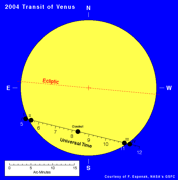
A transit of Venus across the disk of the Sun is among the rarest of planetary alignments. The last transit occurred 120 years ago in 1882, while the next one takes place on 2004 June 08. Figure 1 (Small Figure, Large Figure) shows the geocentric path of Venus across the Sun. The scale along the track gives the Universal Time[1] of Venus's position at any instant. The planet moves westward with respect to the Sun and inscribes a chord through the Sun's southern hemisphere. Moving with an angular speed of 3.2 arc-minutes per hour, Venus takes about 6.2 hours to cross the Sun's disk.
The transit begins with contact I when the limb of Venus is externally tangent with the Sun. It takes about nineteen minutes for the planet's disk to cross the solar limb where it becomes internally tangent with the Sun at contact II. The period between contacts I and II is known as ingress. At the end of ingress, the entire disk of Venus is seen silhouetted against the Sun's disk as it begins its slow six-hour passage across our star.
Contact III occurs when Venus reaches and first touches the opposite limb of the Sun. Another nineteen minutes elapse as the planet gradually exits the solar disk. Finally, the transit ends with contact IV when Venus's disk completely exits the Sun and the planet vanishes from sight. The period from contact III to IV is referred to as egress.
| Event | Universal Time | Description |
| Contact I | 05:13:29 | ingress begins |
| Contact II | 05:32:55 | ingress ends |
| Greatest | 08:19:44 | minimum angular distance |
| Contact III | 11:06:33 | egress begins |
| Contact IV | 11:25:59 | egress ends |
Table 1 gives the times of major events during the transit. Greatest transit is the instant when Venus passes closest to the Sun's center (i.e. - minimum angular separation). During the 2004 transit, Venus's minimum separation from the Sun is 627 arc-seconds. These contact times are actually for an observer at Earth's center. The contact times at other locations will differ up to plus or minus seven minutes. This effect is due to parallax since Venus's position will shift slightly[2] depending on the observer's geographic coordinates on Earth. For the times of each stage of the transit from various cities around the world, see the tables at Transit Contact Times.
[1] Universal Time or UT is the basis for the worldwide system of civil time. It is often referred to as Greenwich Mean Time although UT is actually based on atomic clock time rather than the Sun's mean motion. For more information, see All About Time Zones and Universal Time.
[2] Venus's 58 arc-second disk may be shifted up to 30 arc-seconds from its geocentric coordinates depending on the observer's geographic position on Earth.
The transit will be visible from the entire daylight hemisphere of Earth. But since the event lasts over six hours, Earth will rotate 1/4 revolution between the times of ingress and egress. Consequently, some geographic areas will see the entire transit while others witness only part of the event (including either ingress or egress). Finally, about a quarter of Earth will see none of the transit since the Sun will be below the horizon throughout the entire period.
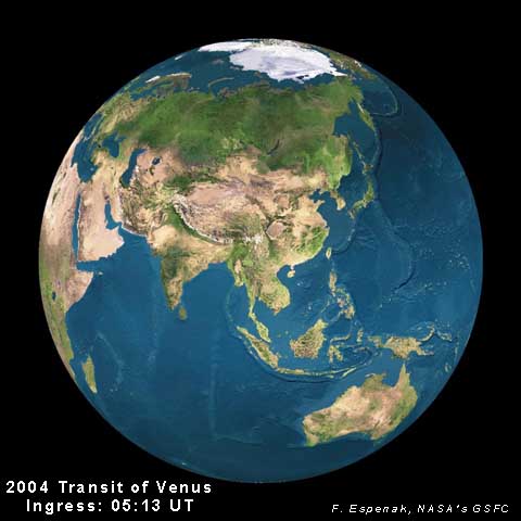
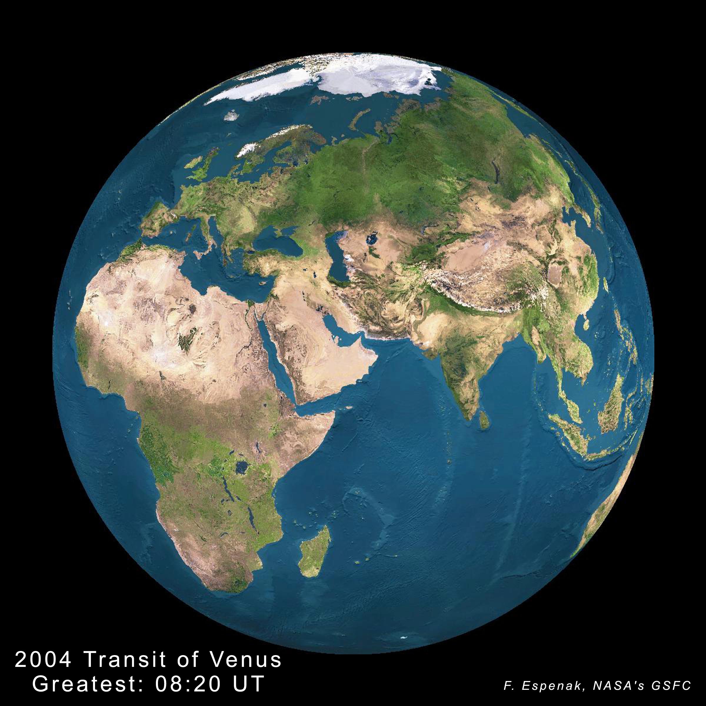
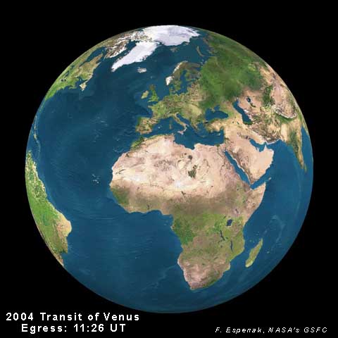
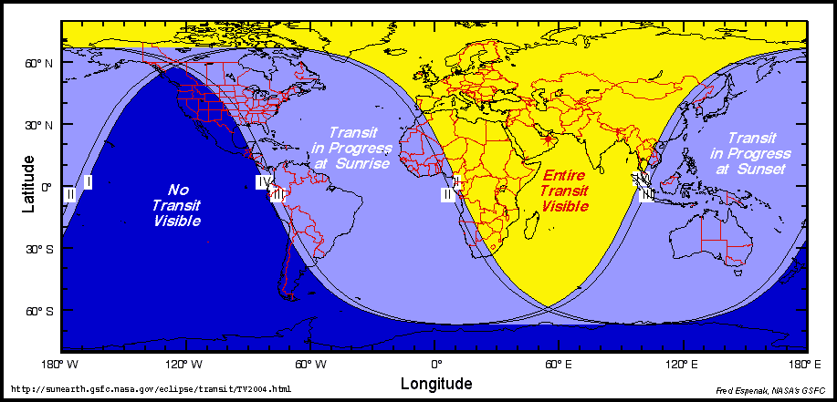
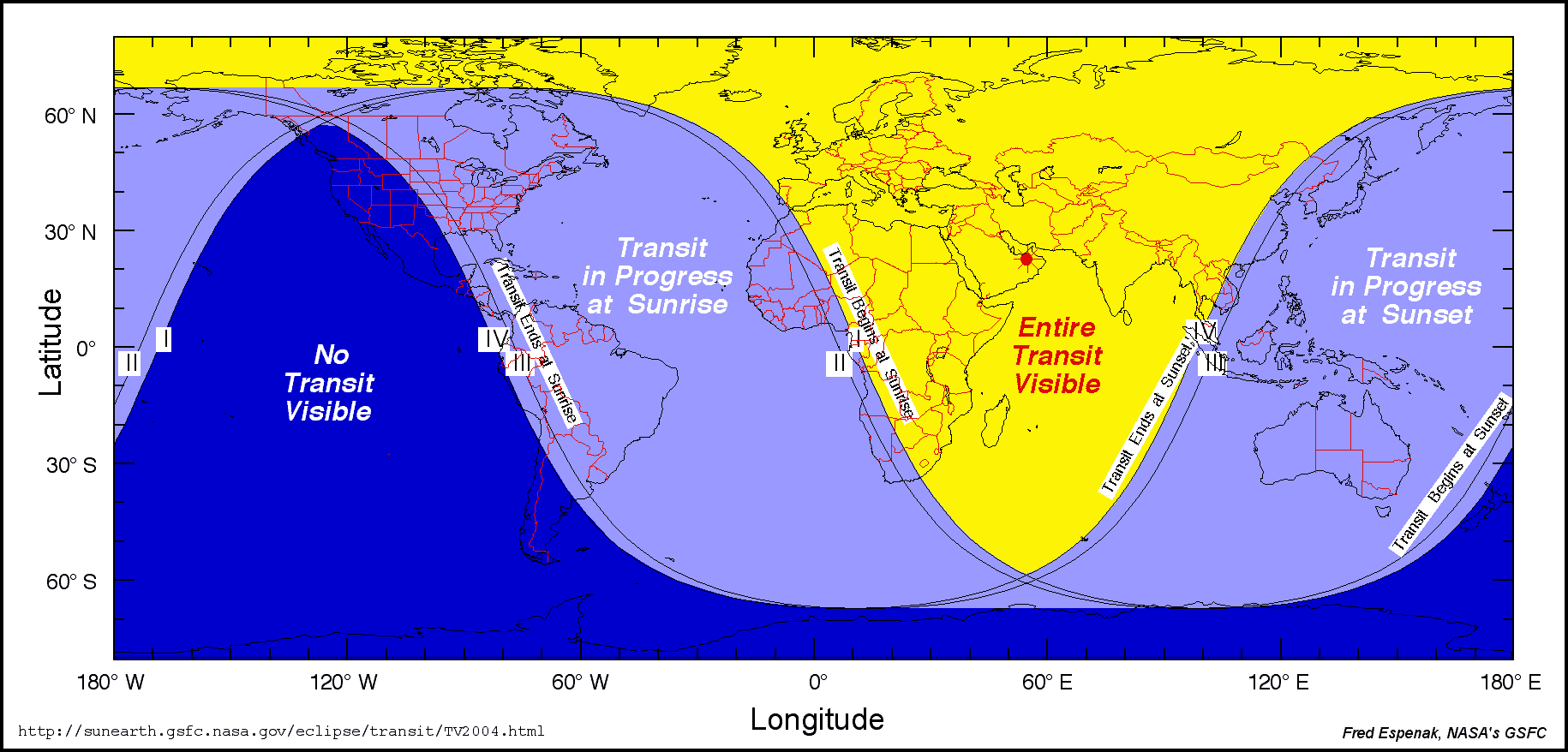
At ingress (Figure 2 - Small Size, Large Size), the transit will be observable from all of Asia, Australia, Europe, and high northern latitude including Alaska, northern Canada, Greenland and Iceland. At greatest or mid-transit (Figure 3 - Small Size, Large Size), the event will be visible from Europe, Africa, Asia, western Australia, and high northern latitudes. At egress (Figure 4 - Small Size, Large Size), the transit will be observable from all of Africa, Europe, central Asia, eastern North America, northern South America, and high northern latitudes including Greenland, Iceland and northern Canada.
As Earth rotates, the Sun will set before the transit ends from Japan, Indonesia, the Philippines, Australia and easternmost Asia, so these regions will miss egress. Similarly, locations in western Africa, eastern North America, the Caribbean and northern South America will find the transit already in progress as the Sun rises. As a result, these locales will miss ingress.
The entire transit is observable from Europe, north and east Africa, and Asia (except far east). In contrast, none of the transit will be seen from western North America, the eastern Pacific (including Hawaii), southern South America (Chile and southern Argentina) and Antarctica. Western states in the U. S. which miss the transit include: Arizona, California, Colorado, Idaho, Nevada, New Mexico, Montana, Oregon, Texas, Utah, Washington and Wyoming.
The world visibility map (Figure 5 - Small Size, Large Size) depicts the geographic locations from which each phase of the transit is visible. This map does not include refraction, which could increase the region of visibility by about half a degree.
North and South America
Europe & Atlantic Ocean
Africa & Asia
Oceania
The beginning of the transit may be visible from the very northernmost parts of New Zealand only minutes before sunset. From Auckland, external ingress (contact I) takes place at 05:06:42 UT. The Sun's altitude will be about 0.4 degrees (includes refraction). The Sun will set a few minutes later (about 05:10 UT).
Please note that from the Hawaiian Islands, the transit begins just before sunset on June 7!
From Kauai, External Ingress (contact I) takes place at 05:08:52 UT (07:08:52 pm). The Sun's altitude will be about 1.7 degrees (includes refraction). The Sun will set about ten minutes later (07:19 pm). From Oahu, External Ingress (contact I) also takes place at 05:08:52 UT (07:08:52 pm) but the Sun's altitude will only be about 0.4 degrees (includes refraction). The Sun will set about five minutes later (07:12 pm). The transit is not visible from the Big Island of Hawaii.
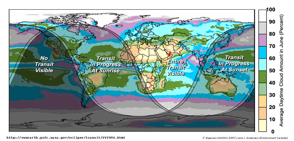
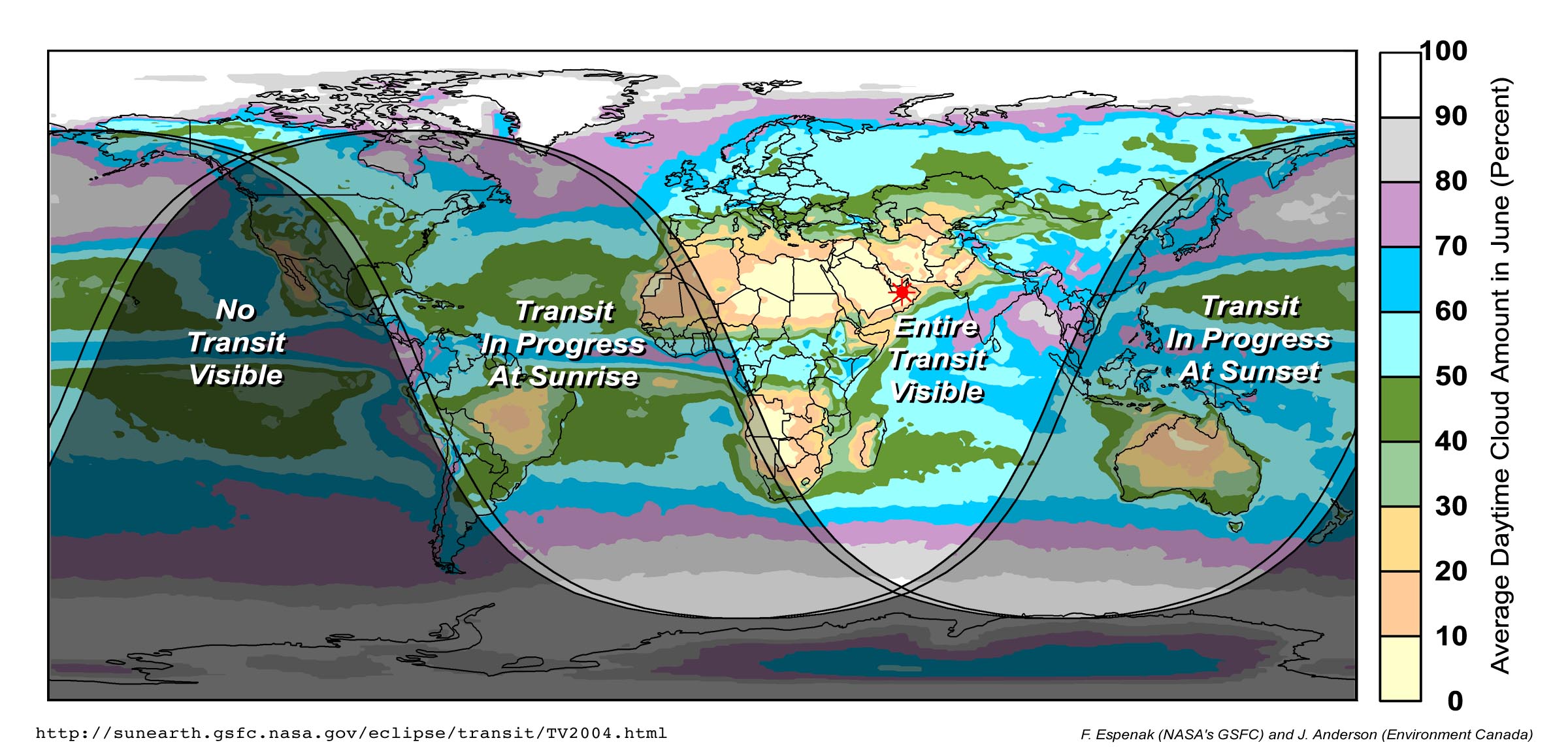
The rarity of this event demands that special attention be given to the long-range weather prospects. Cloud cover maps (Figure 6 - Small Size, Large Size) show that the most promising skies for transit observations occur in two parallel low latitude bands straddling the equator. South of the equator, this band of minimal cloudiness runs from Brazil to southern Africa and Australia. In the northern hemisphere, the band runs across the southern United States, northern Africa and the Middle East, being interrupted across India and Southeast Asia by the onset of the southeast monsoon. The two regions are separated by the high cloudiness associated with the Intertropical Convergence Zone (ICZ) that runs approximately along the equator.
The low cloud zones are associated with the semi-permanent high pressure anticyclones found in June over the oceans at 35°N and at 25°S. These sub-tropical anticyclones are formed by the large scale Hadley circulation in the atmosphere that exchanges heat and humidity in equatorial regions with colder and drier air near the poles. Descending air in the center of these anticyclones dries the atmosphere through adiabatic warming and it is no accident that the world's great deserts are also found at these latitudes - among them, the Sahara, Kalahari, Atacama, and Arabian Deserts.
Away from the tropics, cloud cover increases rapidly with latitude, though the pattern is greatly modified by the presence of mountain chains that interrupt the flow of weather systems and the transport of moisture from oceans onto land. In North America, the Rocky Mountains block the flow from the Pacific into the continent and permit a zone of low cloudiness that stretches northward from Texas to the Canadian border. In northern Europe, Atlantic moisture flows unrestricted onto the land until being blocked by the Alps and Pyrenees, keeping Germany, France and England under high levels of cloudiness, while preserving the sunnier climates of Italy and Greece. Similar effects can be seen in southern Asia around Kazakhstan and Mongolia, although the favorable cloud patterns there are due as much to the absence of nearby moisture sources as the presence of mountains.
For those who are determined to see the transit in its entirety, the most favorable climatology lies in regions surrounding the Mediterranean, the Middle East, and portions of southern Africa. The Azores High, the closest anticyclone, extends a tentacle of high pressure down the length of the Mediterranean, suppressing cloud-bearing weather systems and helping to extend the reach of the Sahara's dry influence into Italy, Greece and the coasts of Turkey and Spain. Sunshine prospects are even better on the African coast. Clear skies are virtually guaranteed, but high temperatures may make observation of the transit a test of endurance at inland sites.
North America's deserts lie outside the transit's view, but the western plains from Oklahoma northward, offer the best chance for a tantalizing glimpse of the end of the transit at sunrise. The Appalachians and Florida are best avoided unless the forecast of the day calls for sunshine. The entire transit can be seen in the far north, where the sun maintains a continuous 24-hour presence, but cloud prospects border on awful. The global cloud map shows a minimum in cloudiness through parts of Alaska and Canada's Yukon Territory where mountains block some of the flow from the Pacific, but reaching the area will require an expedition down the Alaska Highway, or a flight to one of several high Arctic communities.
Meteorological statistics for the frequency of various amounts of cloud cover for a number of cities in the U. S., Canada, Europe, the Mediterranean and the Middle East can be found in the following tables.
In 1716, Halley proposed that transits of Venus could be used to measure the Sun's distance, thereby establishing the absolute scale of the Solar System and solving one of the greatest problems in astronomy at that time. The technique required that expeditions travel to the far ends of Earth so that the differing parallax of the observations could be used to derive the distance to Venus. Today the distance to the Sun and planets can be measured extremely accurately using radar, so the 2004 transit will have no scientific value in this regard. Still, it is a remarkably rare event, which was of great importance during the early history of astronomy.
With the recent discovery of the first transit of a planet around another star [Henry, Marcy, Butler, and Vogt, 1999] interest in extra-solar transits is high. The 2004 transit of Venus may be of use in developing and testing new techniques and strategies for the detection and characterization of other extra-solar planets.
However, the greatest value of the 2004 transit lies in public outreach and educational opportunities to share this unique event with non-scientists. The public, amateur astronomers, educators, students and the media are genuinely fascinated with the transit and its rich scientific, cultural, political and intellectual history. A few of the educational Web sites focusing on the transit include:
Rarely does an astronomical event occur which can be observed directly by the public using simple equipment. With justifiable concerns about the scientific literacy of today's citizens, the transit is a golden opportunity to stimulate, educate and (dare we say) entertain. It may even serve to ignite the imaginations of a few students who may continue on to become part of the next generation of scientists.
The predictions presented at this NASA 2004 Transit of Venus web site are provided as a resource for the public, educators, media and especially students attempting to measure the scale of the solar system.
